![](/images/other/stat-length.png)
Mont Brune depuis Toudon
aris
Utilisateur
![Longueur](/images/other/stat-length.png)
Longueur
14,7 km
![Altitude max](https://static1.geolcdn.com/siteimages/upload/files/1508320355ic_sort_altitude_max_24dp.png)
Altitude max
1501 m
![Dénivelé positif](https://static1.geolcdn.com/siteimages/upload/files/1508320355ic_sort_den_pos_24dp.png)
Dénivelé positif
972 m
![Km-Effort](/images/other/stat-length.png)
Km-Effort
28 km
![Altitude min](https://static1.geolcdn.com/siteimages/upload/files/1508320355ic_sort_altitude_min_24dp.png)
Altitude min
984 m
![Dénivelé négatif](https://static1.geolcdn.com/siteimages/upload/files/1508320355ic_sort_den_neg_24dp.png)
Dénivelé négatif
968 m
![Boucle](https://static1.geolcdn.com/siteimages/upload/files/16400158638029165_repeat_loop_refresh_sync_direction_icon.png)
Boucle
Oui
Date de création :
2020-10-25 07:22:30.684
Dernière modification :
2020-10-25 15:26:34.673
![Marche](https://static1.geolcdn.com/sitytour/trail-icons/101.png)
5h53
Difficulté : Moyen
![Scannez ce code QR pour ouvrir la randonnée dans l'application SityTrail](https://capi.geolives.com/qq0zvz2zws4bq2lad0pu/sitytour/trails/2587570/qr.png?size=200)
Application GPS de randonnée GRATUITE
À propos
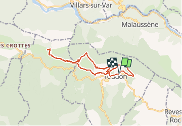
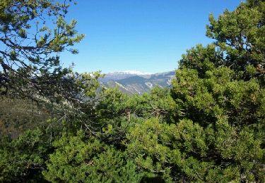
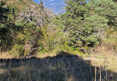
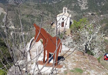
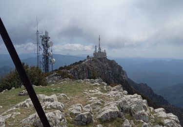
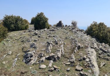
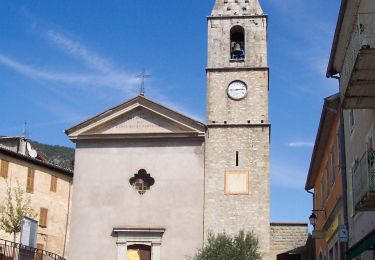
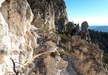
Randonnée Marche de 14,7 km à découvrir à Provence-Alpes-Côte d'Azur, Alpes-Maritimes, Toudon. Cette randonnée est proposée par aris.
Description
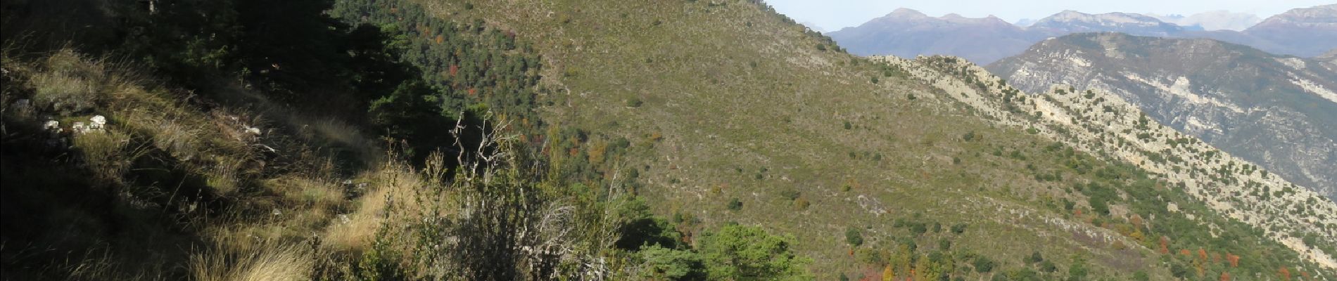
Randonnée facile qui offre de beaux panoramas sur la vallée du Var et le bord de Mer, l'Esteron et le Mercantour. En automne, les couleurs sont superbes.
Localisation
Pays :
France
Région :
Provence-Alpes-Côte d'Azur
Département/Province :
Alpes-Maritimes
Commune :
Toudon
Localité :
Unknown
Départ:(Dec)
Départ:(UTM)
348785 ; 4862808 (32T) N.
Commentaires
Randonnées à proximité
![Randonnée Marche Toudon - FFR - la Cime des Colettes - Photo](https://media.geolcdn.com/t/375/260/5c77e34d-ba93-4b2e-bc78-7f26fc9a91ff.jpg&format=jpg&maxdim=2)
![Marche Marche](https://static1.geolcdn.com/sitytour/trail-icons/101.png)
FFR - la Cime des Colettes
Marche
Difficile
(1)
Toudon,
Provence-Alpes-Côte d'Azur,
Alpes-Maritimes,
France
![](/images/other/stat-length.png)
7,9 km | 15 km-effort
3h 23min
![](https://static1.geolcdn.com/siteimages/upload/files/16400158638029165_repeat_loop_refresh_sync_direction_icon.png)
Oui
![Randonnée A pied Toudon - Cime des Collettes - Photo](https://media.geolcdn.com/t/375/260/fd183395-f287-4a75-ab4d-8f82bd86c556.jpeg&format=jpg&maxdim=2)
![A pied A pied](https://static1.geolcdn.com/sitytour/trail-icons/100.png)
Cime des Collettes
A pied
Facile
Toudon,
Provence-Alpes-Côte d'Azur,
Alpes-Maritimes,
France
![](/images/other/stat-length.png)
7 km | 13,4 km-effort
3h 3min
![](https://static1.geolcdn.com/siteimages/upload/files/16400158638029165_repeat_loop_refresh_sync_direction_icon.png)
Oui
![Randonnée Marche Toudon - cime des Colettes - Photo](https://media.geolcdn.com/t/375/260/ext.jpg?maxdim=2&url=https%3A%2F%2Fservices.sitytrail.com%2FGeolivesWS%2FDownloadMedia.ashx%3FTrailID%3D234784%26Media%3Dfix__20131128111641.jpg)
![Marche Marche](https://static1.geolcdn.com/sitytour/trail-icons/101.png)
cime des Colettes
Marche
Moyen
(1)
Toudon,
Provence-Alpes-Côte d'Azur,
Alpes-Maritimes,
France
![](/images/other/stat-length.png)
7,7 km | 14,6 km-effort
3h 40min
![](https://static1.geolcdn.com/siteimages/upload/files/16400158638029165_repeat_loop_refresh_sync_direction_icon.png)
Non
![Randonnée Marche Revest-les-Roches - Balme de Vial - Photo](https://media.geolcdn.com/t/375/260/73ac1471-1060-4737-8ded-c7a6c570aa13.jpg&format=jpg&maxdim=2)
![Marche Marche](https://static1.geolcdn.com/sitytour/trail-icons/101.png)
Balme de Vial
Marche
Moyen
Revest-les-Roches,
Provence-Alpes-Côte d'Azur,
Alpes-Maritimes,
France
![](/images/other/stat-length.png)
7,4 km | 14,6 km-effort
5h 1min
![](https://static1.geolcdn.com/siteimages/upload/files/16400158638029165_repeat_loop_refresh_sync_direction_icon.png)
Non
![Randonnée Marche La Tour - Pic charvet, son Fort, Chapelle St Antoine, Tournefort - Photo](https://media.geolcdn.com/t/375/260/f393b76f-0e11-49af-9bd1-d986a17cd1fb.jpg&format=jpg&maxdim=2)
![Marche Marche](https://static1.geolcdn.com/sitytour/trail-icons/101.png)
Pic charvet, son Fort, Chapelle St Antoine, Tournefort
Marche
Facile
La Tour,
Provence-Alpes-Côte d'Azur,
Alpes-Maritimes,
France
![](/images/other/stat-length.png)
12,8 km | 23 km-effort
5h 10min
![](https://static1.geolcdn.com/siteimages/upload/files/16400158638029165_repeat_loop_refresh_sync_direction_icon.png)
Oui
![Randonnée Marche Revest-les-Roches - Mont Vial 1550m 18-04-22 - Photo](https://media.geolcdn.com/t/375/260/d6f644e7-05d3-4637-b742-d9794d83f920.jpg&format=jpg&maxdim=2)
![Marche Marche](https://static1.geolcdn.com/sitytour/trail-icons/101.png)
Mont Vial 1550m 18-04-22
Marche
Moyen
Revest-les-Roches,
Provence-Alpes-Côte d'Azur,
Alpes-Maritimes,
France
![](/images/other/stat-length.png)
9,7 km | 19,1 km-effort
3h 30min
![](https://static1.geolcdn.com/siteimages/upload/files/16400158638029165_repeat_loop_refresh_sync_direction_icon.png)
Oui
![Randonnée Marche Pierrefeu - mont brune - Photo](https://media.geolcdn.com/t/375/260/aaa7df74-5173-4c01-a387-0027aa66640a.jpg&format=jpg&maxdim=2)
![Marche Marche](https://static1.geolcdn.com/sitytour/trail-icons/101.png)
mont brune
Marche
Difficile
Pierrefeu,
Provence-Alpes-Côte d'Azur,
Alpes-Maritimes,
France
![](/images/other/stat-length.png)
8 km | 13,7 km-effort
3h 13min
![](https://static1.geolcdn.com/siteimages/upload/files/16400158638029165_repeat_loop_refresh_sync_direction_icon.png)
Oui
![Randonnée A pied Villars-sur-Var - Chapelle Saint-Jean - Photo](https://media.geolcdn.com/t/375/260/d00b81a8-2e28-44d5-b86a-fc3ec125a764.jpeg&format=jpg&maxdim=2)
![A pied A pied](https://static1.geolcdn.com/sitytour/trail-icons/100.png)
Chapelle Saint-Jean
A pied
Facile
Villars-sur-Var,
Provence-Alpes-Côte d'Azur,
Alpes-Maritimes,
France
![](/images/other/stat-length.png)
5 km | 9,7 km-effort
2h 12min
![](https://static1.geolcdn.com/siteimages/upload/files/16400158638029165_repeat_loop_refresh_sync_direction_icon.png)
Oui
![Randonnée Marche Toudon - Baisse des Colettes et Mt Brune de Toudon - Photo](https://media.geolcdn.com/t/375/260/20f8a02d-71d1-45f3-9a82-b8f740ad91d7.jpg&format=jpg&maxdim=2)
![Marche Marche](https://static1.geolcdn.com/sitytour/trail-icons/101.png)
Baisse des Colettes et Mt Brune de Toudon
Marche
Moyen
(1)
Toudon,
Provence-Alpes-Côte d'Azur,
Alpes-Maritimes,
France
![](/images/other/stat-length.png)
13,3 km | 24 km-effort
4h 39min
![](https://static1.geolcdn.com/siteimages/upload/files/16400158638029165_repeat_loop_refresh_sync_direction_icon.png)
Oui