![](/images/other/stat-length.png)
![Randonnée Marche Le Tampon - La Réunion - Boucle du parcours sportif de Bel Air, par la ravine de la rivière d'abord. - Photo](https://media.geolcdn.com/t/1900/400/ext.pjpeg?maxdim=2&url=https%3A%2F%2Fservices.sitytrail.com%2FGeolivesWS%2FDownloadMedia.ashx%3FTrailID%3D258585%26Media%3Dfix__20140319154522.jpg)
La Réunion - Boucle du parcours sportif de Bel Air, par la ravine de la rivière d'abord.
olive2b
Utilisateur
![Longueur](/images/other/stat-length.png)
Longueur
4 km
![Altitude max](https://static1.geolcdn.com/siteimages/upload/files/1508320355ic_sort_altitude_max_24dp.png)
Altitude max
500 m
![Dénivelé positif](https://static1.geolcdn.com/siteimages/upload/files/1508320355ic_sort_den_pos_24dp.png)
Dénivelé positif
116 m
![Km-Effort](/images/other/stat-length.png)
Km-Effort
5,5 km
![Altitude min](https://static1.geolcdn.com/siteimages/upload/files/1508320355ic_sort_altitude_min_24dp.png)
Altitude min
406 m
![Dénivelé négatif](https://static1.geolcdn.com/siteimages/upload/files/1508320355ic_sort_den_neg_24dp.png)
Dénivelé négatif
109 m
![Boucle](https://static1.geolcdn.com/siteimages/upload/files/16400158638029165_repeat_loop_refresh_sync_direction_icon.png)
Boucle
Oui
Date de création :
2016-03-09 00:00:00.0
Dernière modification :
2016-03-09 00:00:00.0
![Marche](https://static1.geolcdn.com/sitytour/trail-icons/101.png)
1h22
Difficulté : Facile
![Scannez ce code QR pour ouvrir la randonnée dans l'application SityTrail](https://capi.geolives.com/qq0zvz2zws4bq2lad0pu/sitytour/trails/258585/qr.png?size=200)
Application GPS de randonnée GRATUITE
À propos
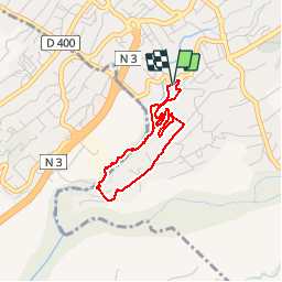
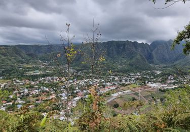
Randonnée Marche de 4 km à découvrir à La Réunion, Inconnu, Le Tampon. Cette randonnée est proposée par olive2b.
Description
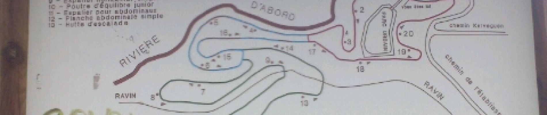
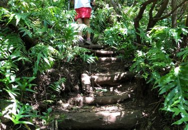
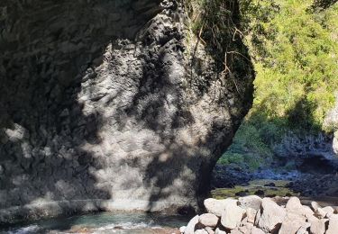
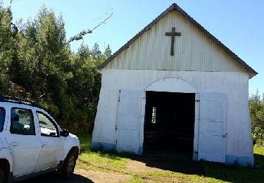
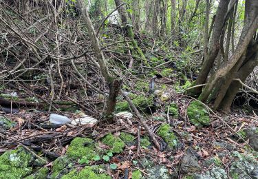
Balade agréable sur la première partie du chemin quand on descend dans la ravine de la rivière d'abord. La seconde partie est juste une liaison jusqu'à la troisième partie qui est le parcours sportif.
Localisation
Pays :
France
Région :
La Réunion
Département/Province :
Inconnu
Commune :
Le Tampon
Localité :
Unknown
Départ:(Dec)
Départ:(UTM)
346330 ; 7645037 (40K) S.
Commentaires
Randonnées à proximité
![Randonnée Marche Saint-Pierre - Piton Mont Vert 20190217 SH - Photo](https://media.geolcdn.com/t/375/260/6915dbe3-caff-46a5-a466-fa66dec5f931.jpg&format=jpg&maxdim=2)
![Marche Marche](https://static1.geolcdn.com/sitytour/trail-icons/101.png)
Piton Mont Vert 20190217 SH
Marche
Moyen
(1)
Saint-Pierre,
La Réunion,
Inconnu,
France
![](/images/other/stat-length.png)
2,3 km | 3,7 km-effort
1h 42min
![](https://static1.geolcdn.com/siteimages/upload/files/16400158638029165_repeat_loop_refresh_sync_direction_icon.png)
Oui
![Randonnée Marche Le Tampon - Sentier Dassy ( Tampon) - Photo](https://media.geolcdn.com/t/375/260/ext.jpg?maxdim=2&url=https%3A%2F%2Fstatic1.geolcdn.com%2Fsiteimages%2Fupload%2Ffiles%2F1553511878bg_sport_marche.png)
![Marche Marche](https://static1.geolcdn.com/sitytour/trail-icons/101.png)
Sentier Dassy ( Tampon)
Marche
Moyen
(1)
Le Tampon,
La Réunion,
Inconnu,
France
![](/images/other/stat-length.png)
5,6 km | 12,3 km-effort
1h 25min
![](https://static1.geolcdn.com/siteimages/upload/files/16400158638029165_repeat_loop_refresh_sync_direction_icon.png)
Oui
![Randonnée Marche Entre-Deux - Tour d'Entre Deux - Photo](https://media.geolcdn.com/t/375/260/ext.jpg?maxdim=2&url=https%3A%2F%2Fstatic1.geolcdn.com%2Fsiteimages%2Fupload%2Ffiles%2F1553511878bg_sport_marche.png)
![Marche Marche](https://static1.geolcdn.com/sitytour/trail-icons/101.png)
Tour d'Entre Deux
Marche
Moyen
(1)
Entre-Deux,
La Réunion,
Inconnu,
France
![](/images/other/stat-length.png)
10,6 km | 17,9 km-effort
4h 0min
![](https://static1.geolcdn.com/siteimages/upload/files/16400158638029165_repeat_loop_refresh_sync_direction_icon.png)
Oui
![Randonnée Marche Entre-Deux - Le tour de l'entre-deux - Photo](https://media.geolcdn.com/t/375/260/43411191-273a-4292-a289-21264fab8423.jpg&format=jpg&maxdim=2)
![Marche Marche](https://static1.geolcdn.com/sitytour/trail-icons/101.png)
Le tour de l'entre-deux
Marche
Moyen
Entre-Deux,
La Réunion,
Inconnu,
France
![](/images/other/stat-length.png)
9,4 km | 15,3 km-effort
3h 8min
![](https://static1.geolcdn.com/siteimages/upload/files/16400158638029165_repeat_loop_refresh_sync_direction_icon.png)
Oui
![Marche Marche](https://static1.geolcdn.com/sitytour/trail-icons/101.png)
RandoPitons.re #1416 - De Sentier Dassy au barage par le Bras de la Plaine
Marche
Difficile
Le Tampon,
La Réunion,
Inconnu,
France
![](/images/other/stat-length.png)
8,7 km | 16,9 km-effort
3h 18min
![](https://static1.geolcdn.com/siteimages/upload/files/16400158638029165_repeat_loop_refresh_sync_direction_icon.png)
Non
![Randonnée Marche Entre-Deux - Dimitile en 4x4 et à pied - Photo](https://media.geolcdn.com/t/375/260/ext.jpg?maxdim=2&url=https%3A%2F%2Fservices.sitytrail.com%2FGeolivesWS%2FDownloadMedia.ashx%3FTrailID%3D452672%26Media%3Dfix__20150710123136.jpg)
![Marche Marche](https://static1.geolcdn.com/sitytour/trail-icons/101.png)
Dimitile en 4x4 et à pied
Marche
Moyen
Entre-Deux,
La Réunion,
Inconnu,
France
![](/images/other/stat-length.png)
41 km | 69 km-effort
5h 47min
![](https://static1.geolcdn.com/siteimages/upload/files/16400158638029165_repeat_loop_refresh_sync_direction_icon.png)
Non
![Randonnée Marche Le Tampon - 2023 11-12-reconnaissance de la ravine cascade - Photo](https://media.geolcdn.com/t/375/260/ca3aad43-4450-4f7b-96ba-cf859159a906.jpg&format=jpg&maxdim=2)
![Marche Marche](https://static1.geolcdn.com/sitytour/trail-icons/101.png)
2023 11-12-reconnaissance de la ravine cascade
Marche
Facile
Le Tampon,
La Réunion,
Inconnu,
France
![](/images/other/stat-length.png)
1,7 km | 2,6 km-effort
21min
![](https://static1.geolcdn.com/siteimages/upload/files/16400158638029165_repeat_loop_refresh_sync_direction_icon.png)
Non
![Randonnée Marche Entre-Deux - Fond de la Rivière - Photo](https://media.geolcdn.com/t/375/260/ext.jpg?maxdim=2&url=https%3A%2F%2Fstatic1.geolcdn.com%2Fsiteimages%2Fupload%2Ffiles%2F1553511878bg_sport_marche.png)
![Marche Marche](https://static1.geolcdn.com/sitytour/trail-icons/101.png)
Fond de la Rivière
Marche
Facile
Entre-Deux,
La Réunion,
Inconnu,
France
![](/images/other/stat-length.png)
3,1 km | 6 km-effort
1h 22min
![](https://static1.geolcdn.com/siteimages/upload/files/16400158638029165_repeat_loop_refresh_sync_direction_icon.png)
Oui
![Randonnée Marche Entre-Deux - Fond de la rivière - Photo](https://media.geolcdn.com/t/375/260/ext.jpg?maxdim=2&url=https%3A%2F%2Fstatic1.geolcdn.com%2Fsiteimages%2Fupload%2Ffiles%2F1553511878bg_sport_marche.png)
![Marche Marche](https://static1.geolcdn.com/sitytour/trail-icons/101.png)
Fond de la rivière
Marche
Difficile
Entre-Deux,
La Réunion,
Inconnu,
France
![](/images/other/stat-length.png)
4,4 km | 9,2 km-effort
1h 50min
![](https://static1.geolcdn.com/siteimages/upload/files/16400158638029165_repeat_loop_refresh_sync_direction_icon.png)
Oui