![](/images/other/stat-length.png)
![Randonnée Randonnée équestre Fernelmont - GAL boucle](https://media.geolcdn.com/t/1900/400/ext.pjpeg?maxdim=2&url=https%3A%2F%2Fstatic1.geolcdn.com%2Fsiteimages%2Fupload%2Ffiles%2F1524743154cheval.jpg)
GAL boucle "rouge" Meeffe Seron Hanret Fernelmont
Les cavaliers et meneurs de l'ARTE Liège
Balades et randonnées à cheval en province de Liège
![Longueur](/images/other/stat-length.png)
Longueur
21 km
![Altitude max](https://static1.geolcdn.com/siteimages/upload/files/1508320355ic_sort_altitude_max_24dp.png)
Altitude max
187 m
![Dénivelé positif](https://static1.geolcdn.com/siteimages/upload/files/1508320355ic_sort_den_pos_24dp.png)
Dénivelé positif
160 m
![Km-Effort](/images/other/stat-length.png)
Km-Effort
23 km
![Altitude min](https://static1.geolcdn.com/siteimages/upload/files/1508320355ic_sort_altitude_min_24dp.png)
Altitude min
135 m
![Dénivelé négatif](https://static1.geolcdn.com/siteimages/upload/files/1508320355ic_sort_den_neg_24dp.png)
Dénivelé négatif
160 m
![Boucle](https://static1.geolcdn.com/siteimages/upload/files/16400158638029165_repeat_loop_refresh_sync_direction_icon.png)
Boucle
Oui
Date de création :
2020-10-16 14:44:40.288
Dernière modification :
2020-10-19 09:27:33.501
![Randonnée équestre](https://static1.geolcdn.com/sitytour/trail-icons/301.png)
3h50
Difficulté : Moyen
![Scannez ce code QR pour ouvrir la randonnée dans l'application SityTrail](https://capi.geolives.com/qq0zvz2zws4bq2lad0pu/sitytour/trails/2578951/qr.png?size=200)
Application GPS de randonnée GRATUITE
À propos
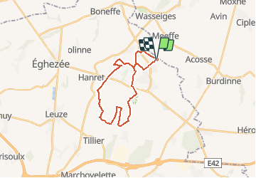
Randonnée Randonnée équestre de 21 km à découvrir à Wallonie, Namur, Fernelmont. Cette randonnée est proposée par Les cavaliers et meneurs de l'ARTE Liège.
Description
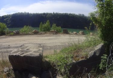
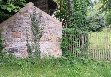
Avec un maximum de chemins naturels.
Pour chevaux, vtt, marcheurs, ...
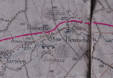
Départ aux tombes de Seron, mais autres parkings possibles sur la boucle.
Localisation
Pays :
Belgique
Région :
Wallonie
Département/Province :
Namur
Commune :
Fernelmont
Localité :
Forville
Départ:(Dec)
Départ:(UTM)
642091 ; 5606535 (31U) N.
Commentaires
Randonnées à proximité
![Randonnée Marche Wasseiges - 20240307 - TOTEMUS Meeffe - 5.8 Km - Photo](https://media.geolcdn.com/t/375/260/7d0d7efb-8092-424b-91ec-d478748d7f53.jpeg&format=jpg&maxdim=2)
![Marche Marche](https://static1.geolcdn.com/sitytour/trail-icons/101.png)
20240307 - TOTEMUS Meeffe - 5.8 Km
Marche
Facile
Wasseiges,
Wallonie,
Liège,
Belgique
![](/images/other/stat-length.png)
5,8 km | 6,3 km-effort
1h 56min
![](https://static1.geolcdn.com/siteimages/upload/files/16400158638029165_repeat_loop_refresh_sync_direction_icon.png)
Oui
![Randonnée Marche Wasseiges - 20240307 - TOTEMUS Wasseiges- 3.2 Km - Photo](https://media.geolcdn.com/t/375/260/c42a9b7b-cd65-45b2-bbb9-49294bcad449.jpeg&format=jpg&maxdim=2)
![Marche Marche](https://static1.geolcdn.com/sitytour/trail-icons/101.png)
20240307 - TOTEMUS Wasseiges- 3.2 Km
Marche
Facile
Wasseiges,
Wallonie,
Liège,
Belgique
![](/images/other/stat-length.png)
3,2 km | 3,5 km-effort
48min
![](https://static1.geolcdn.com/siteimages/upload/files/16400158638029165_repeat_loop_refresh_sync_direction_icon.png)
Oui
![V.T.T. V.T.T.](https://static1.geolcdn.com/sitytour/trail-icons/202.png)
VTT autour de Burdinne
V.T.T.
Très difficile
Burdinne,
Wallonie,
Liège,
Belgique
![](/images/other/stat-length.png)
55 km | 68 km-effort
4h 41min
![](https://static1.geolcdn.com/siteimages/upload/files/16400158638029165_repeat_loop_refresh_sync_direction_icon.png)
Oui
![Randonnée Vélo Fernelmont - LA HESBAYE A VELO N? 4 - Photo](https://media.geolcdn.com/t/375/260/ext.jpg?maxdim=2&url=https%3A%2F%2Fstatic1.geolcdn.com%2Fsiteimages%2Fupload%2Ffiles%2F1524743154velo.jpg)
![Vélo Vélo](https://static1.geolcdn.com/sitytour/trail-icons/200.png)
LA HESBAYE A VELO N? 4
Vélo
Très facile
(1)
Fernelmont,
Wallonie,
Namur,
Belgique
![](/images/other/stat-length.png)
24 km | 26 km-effort
1h 30min
![](https://static1.geolcdn.com/siteimages/upload/files/16400158638029165_repeat_loop_refresh_sync_direction_icon.png)
Oui
![Randonnée Marche Burdinne - marche adeps Burdinne - Photo](https://media.geolcdn.com/t/375/260/5342bef7-2c97-4df4-b8b0-8cd5ca7152b6.jpg&format=jpg&maxdim=2)
![Marche Marche](https://static1.geolcdn.com/sitytour/trail-icons/101.png)
marche adeps Burdinne
Marche
Facile
Burdinne,
Wallonie,
Liège,
Belgique
![](/images/other/stat-length.png)
11,6 km | 13,4 km-effort
2h 45min
![](https://static1.geolcdn.com/siteimages/upload/files/16400158638029165_repeat_loop_refresh_sync_direction_icon.png)
Oui
![Randonnée A pied Héron - Promenade de la Dîme - Photo](https://media.geolcdn.com/t/375/260/ext.jpg?maxdim=2&url=https%3A%2F%2Fpivotmedia.tourismewallonie.be%2FANX-0N-004G-00BM%2FANX-0N-004G-00BM.jpg)
![A pied A pied](https://static1.geolcdn.com/sitytour/trail-icons/100.png)
Promenade de la Dîme
A pied
Facile
Héron,
Wallonie,
Liège,
Belgique
![](/images/other/stat-length.png)
11 km | 12,6 km-effort
2h 51min
![](https://static1.geolcdn.com/siteimages/upload/files/16400158638029165_repeat_loop_refresh_sync_direction_icon.png)
Oui
![Randonnée Marche Fernelmont - Fonds Jacques Goor Points Verts 10 km - Photo](https://media.geolcdn.com/t/375/260/ext.jpg?maxdim=2&url=https%3A%2F%2Fstatic1.geolcdn.com%2Fsiteimages%2Fupload%2Ffiles%2F1553511878bg_sport_marche.png)
![Marche Marche](https://static1.geolcdn.com/sitytour/trail-icons/101.png)
Fonds Jacques Goor Points Verts 10 km
Marche
Moyen
(1)
Fernelmont,
Wallonie,
Namur,
Belgique
![](/images/other/stat-length.png)
10,8 km | 11,9 km-effort
2h 38min
![](https://static1.geolcdn.com/siteimages/upload/files/16400158638029165_repeat_loop_refresh_sync_direction_icon.png)
Oui
![Randonnée Marche Fernelmont - bois de Bierwart 4,20 km - Photo](https://media.geolcdn.com/t/375/260/ext.jpg?maxdim=2&url=https%3A%2F%2Fstatic1.geolcdn.com%2Fsiteimages%2Fupload%2Ffiles%2F1553511878bg_sport_marche.png)
![Marche Marche](https://static1.geolcdn.com/sitytour/trail-icons/101.png)
bois de Bierwart 4,20 km
Marche
Facile
(2)
Fernelmont,
Wallonie,
Namur,
Belgique
![](/images/other/stat-length.png)
4,2 km | 4,8 km-effort
1h 3min
![](https://static1.geolcdn.com/siteimages/upload/files/16400158638029165_repeat_loop_refresh_sync_direction_icon.png)
Oui
![Randonnée Marche Éghezée - Balade sur les traces du train Zaman - Photo](https://media.geolcdn.com/t/375/260/aa779541-57bf-4787-a340-ddeffd6c194f.jpg&format=jpg&maxdim=2)
![Marche Marche](https://static1.geolcdn.com/sitytour/trail-icons/101.png)
Balade sur les traces du train Zaman
Marche
Difficile
Éghezée,
Wallonie,
Namur,
Belgique
![](/images/other/stat-length.png)
16,2 km | 17,6 km-effort
3h 54min
![](https://static1.geolcdn.com/siteimages/upload/files/16400158638029165_repeat_loop_refresh_sync_direction_icon.png)
Oui