Randonnée Marche Wattwiller - 68  Wattwiller - Cimetière Uhlans - Photo

68 Wattwiller - Cimetière Uhlans

 E.BURCK
E.BURCK

Utilisateur

© OpenStreetMap contributors
Longueur
Longueur
7,2 km
Altitude max
Altitude max
617 m
Dénivelé positif
Dénivelé positif
298 m
Km-Effort
Km-Effort  
11,2 km
Altitude min
Altitude min
334 m
Dénivelé négatif
Dénivelé négatif
298 m
Boucle
Boucle
Oui
Date de création :
2020-10-15 06:29:25.215
Dernière modification :
2021-02-28 10:36:59.46

(0 Avis)

Marche
Marche
3h26
Difficulté : Moyen

Scannez ce code QR pour ouvrir la randonnée dans l'application SityTrail

Application GPS de randonnée GRATUITE

Logo SityTrail SityTrail

IGN / Instituts géographiques

Télécharger SityTrail sur l'App Store Télécharger SityTrail sur Google Play

Logo SityTrail SityTrail World

Le monde est à vous

Télécharger SityTrail sur l'App Store Télécharger SityTrail sur Google Play Télécharger SityTrail sur Huawei AppGallery

À propos

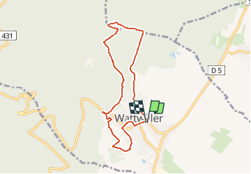
Randonnée Marche de 7,2 km à découvrir à Grand Est, Haut-Rhin, Wattwiller. Cette randonnée est proposée par E.BURCK.

Description

en partant de Wattwiller : 6,7 km et 270 m de dénivelé. S

ACCÈS :  
   -  WATTWILLER: aller dans la rue du Général de Gaulle.
PARKING:
    - au croisement de la rue du Général de Gaulle avec la rue de la Cantine  : le parking de la Salle Krafft.
47.836526 ,   7.182469   ou        
N 47°50'11.5"      E  07°10'56.9"  
                                       

Profil altimétrique

Localisation

Pays :
France
Région :
Grand Est
Département/Province :
Haut-Rhin
Commune :
Wattwiller
Localité :
Unknown
Départ:(Dec)
Départ:(UTM)
364003 ; 5299715 (32T) N.

Randonnées à proximité

Randonnée Marche Soultz-Haut-Rhin - Hartmannswillerkopf - Circuit découverte - Photo
Marche
VacheKiri67

Marche

Facile
(1)
Soultz-Haut-Rhin, Grand Est, Haut-Rhin, France
3,6 km | 5,2 km-effort
1h 46min
Oui
Randonnée Marche Soultz-Haut-Rhin - Hartmannswillerkopf - Circuit anneau bleu - Photo
Marche
VacheKiri67

Marche

Moyen
(1)
Soultz-Haut-Rhin, Grand Est, Haut-Rhin, France
3,7 km | 5,9 km-effort
1h 37min
Oui
Randonnée Autre activité Steinbach - lac du ballon - Photo
Autre activité
rodabruna

Autre activité

Très facile
(1)
Steinbach, Grand Est, Haut-Rhin, France
33 km | 64 km-effort
5h 1min
Non
Randonnée Trail Wattwiller - The History Ultra - Stage 1 - Photo
Trail
Olivier Houette

Trail

Très facile
(1)
Wattwiller, Grand Est, Haut-Rhin, France
28 km | 48 km-effort
Inconnu
Non
Randonnée Marche Uffholtz - Molkenrain 1 - Photo
Marche
regisbodilis

Marche

Difficile
(1)
Uffholtz, Grand Est, Haut-Rhin, France
15,4 km | 26 km-effort
4h 0min
Oui
Randonnée Marche Steinbach - Rando CLAS du 02/11/2023 - Photo
Marche
boubou68

Marche

Très difficile
Steinbach, Grand Est, Haut-Rhin, France
17,7 km | 27 km-effort
4h 35min
Oui
Randonnée Marche Steinbach - Rando Marcheurs du 03/07/2023 par ALAIN - Photo
Marche
boubou68

Marche

Très difficile
Steinbach, Grand Est, Haut-Rhin, France
20 km | 34 km-effort
5h 1min
Oui
Randonnée Marche Wattwiller - Wattwiller - Domaine du Hirtz (30/03/2023) - Photo
Marche
Richard68500

Marche

Facile
Wattwiller, Grand Est, Haut-Rhin, France
6,1 km | 9,9 km-effort
2h 7min
Oui
Randonnée Marche Soultz-Haut-Rhin - Rando avec 0mar et Mouloud..18/02/2023 - Photo
Marche
boubou68

Marche

Très difficile
Soultz-Haut-Rhin, Grand Est, Haut-Rhin, France
12 km | 20 km-effort
3h 9min
Oui


Fermer
Mes abonnements