![](/images/other/stat-length.png)
![Randonnée Marche Manteyer - Pic de Céüze - Photo](https://media.geolcdn.com/t/1900/400/d5d2a7aa-e169-4533-bb0a-a9909c91e710.jpg&format=pjpeg&maxdim=2)
Pic de Céüze
nadd73
Utilisateur GUIDE
![Longueur](/images/other/stat-length.png)
![Altitude max](https://static1.geolcdn.com/siteimages/upload/files/1508320355ic_sort_altitude_max_24dp.png)
![Dénivelé positif](https://static1.geolcdn.com/siteimages/upload/files/1508320355ic_sort_den_pos_24dp.png)
![Km-Effort](/images/other/stat-length.png)
![Altitude min](https://static1.geolcdn.com/siteimages/upload/files/1508320355ic_sort_altitude_min_24dp.png)
![Dénivelé négatif](https://static1.geolcdn.com/siteimages/upload/files/1508320355ic_sort_den_neg_24dp.png)
![Boucle](https://static1.geolcdn.com/siteimages/upload/files/16400158638029165_repeat_loop_refresh_sync_direction_icon.png)
![Marche](https://static1.geolcdn.com/sitytour/trail-icons/101.png)
5h05
Difficulté : Moyen
![Scannez ce code QR pour ouvrir la randonnée dans l'application SityTrail](https://capi.geolives.com/qq0zvz2zws4bq2lad0pu/sitytour/trails/2575933/qr.png?size=200)
Application GPS de randonnée GRATUITE
À propos
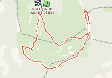
Randonnée Marche de 13,7 km à découvrir à Provence-Alpes-Côte d'Azur, Hautes-Alpes, Manteyer. Cette randonnée est proposée par nadd73.
Description
Départ de Céüze 2000.
Quelques petits pas d'escalade mais très faciles. un passage du ruisseau vers les cascades est peu marqué.
Au pas du Loup : câbles
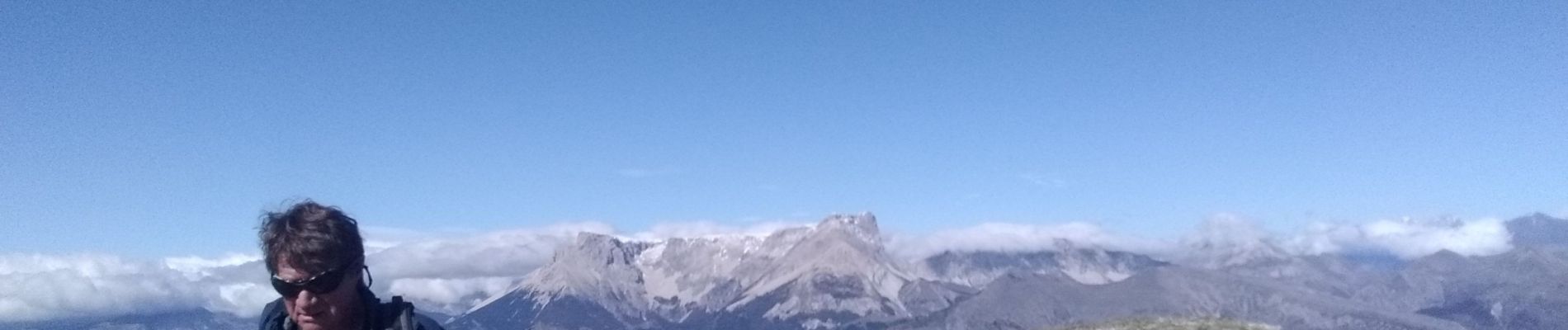
vue magnifique sur le pic de Bure et sur la falaise orangée que l'on longe.
Randonnée où il faut avoir le pied sûr et ne pas avoir peur du vide.
mais je la trouve longue.
Localisation
Commentaires
Randonnées à proximité
![Randonnée Marche Manteyer - R14 Pic de Ceuze - Photo](https://media.geolcdn.com/t/375/260/ext.jpg?maxdim=2&url=https%3A%2F%2Fservices.sitytrail.com%2FGeolivesWS%2FDownloadMedia.ashx%3FTrailID%3D890870%26Media%3D0ba1b82b-7041-4a22-9f15-1bc2a79485cb.jpg)
![Marche Marche](https://static1.geolcdn.com/sitytour/trail-icons/101.png)
Marche
![](/images/other/stat-length.png)
![](https://static1.geolcdn.com/siteimages/upload/files/16400158638029165_repeat_loop_refresh_sync_direction_icon.png)
![Randonnée V.T.T. Manteyer - VTT17 - DE Ceuze à Furmeyer - Photo](https://media.geolcdn.com/t/375/260/ext.jpg?maxdim=2&url=https%3A%2F%2Fservices.sitytrail.com%2FGeolivesWS%2FDownloadMedia.ashx%3FTrailID%3D894053%26Media%3Dff964c78-0895-4177-a23a-bbf5c1f8ef2b.jpg)
![V.T.T. V.T.T.](https://static1.geolcdn.com/sitytour/trail-icons/202.png)
V.T.T.
![](/images/other/stat-length.png)
![](https://static1.geolcdn.com/siteimages/upload/files/16400158638029165_repeat_loop_refresh_sync_direction_icon.png)
![Randonnée V.T.T. Châteauneuf-d'Oze - ceuse9 avril 2012 - Photo](https://media.geolcdn.com/t/375/260/ext.jpg?maxdim=2&url=https%3A%2F%2Fstatic1.geolcdn.com%2Fsiteimages%2Fupload%2Ffiles%2F1524743154velo.jpg)
![V.T.T. V.T.T.](https://static1.geolcdn.com/sitytour/trail-icons/202.png)
V.T.T.
![](/images/other/stat-length.png)
![](https://static1.geolcdn.com/siteimages/upload/files/16400158638029165_repeat_loop_refresh_sync_direction_icon.png)
![Randonnée Trail Châteauneuf-d'Oze - Tour et sommet petite Céüse - Photo](https://media.geolcdn.com/t/375/260/35ba00a4-91ec-4796-9ff5-ca90e4bc8831.jpg&format=jpg&maxdim=2)
![Trail Trail](https://static1.geolcdn.com/sitytour/trail-icons/104.png)
Trail
![](/images/other/stat-length.png)
![](https://static1.geolcdn.com/siteimages/upload/files/16400158638029165_repeat_loop_refresh_sync_direction_icon.png)
![Randonnée Marche Sigoyer - corniche de Ceüze tour - Photo](https://media.geolcdn.com/t/375/260/606b8b0a-ef0b-4016-a35b-711cbf3016a8.jpg&format=jpg&maxdim=2)
![Marche Marche](https://static1.geolcdn.com/sitytour/trail-icons/101.png)
Marche
![](/images/other/stat-length.png)
![](https://static1.geolcdn.com/siteimages/upload/files/16400158638029165_repeat_loop_refresh_sync_direction_icon.png)
![Randonnée Marche Manteyer - Tour de Ceüze - Photo](https://media.geolcdn.com/t/375/260/111429d2-6166-4501-9497-b5a5a3a83e3c.jpg&format=jpg&maxdim=2)
![Marche Marche](https://static1.geolcdn.com/sitytour/trail-icons/101.png)
Marche
![](/images/other/stat-length.png)
![](https://static1.geolcdn.com/siteimages/upload/files/16400158638029165_repeat_loop_refresh_sync_direction_icon.png)
![Randonnée Marche Sigoyer - Petite Ceüze - Photo](https://media.geolcdn.com/t/375/260/a4aca269-bd26-4bc0-bc52-b9c9a64b1557.jpg&format=jpg&maxdim=2)
![Marche Marche](https://static1.geolcdn.com/sitytour/trail-icons/101.png)
Marche
![](/images/other/stat-length.png)
![](https://static1.geolcdn.com/siteimages/upload/files/16400158638029165_repeat_loop_refresh_sync_direction_icon.png)
![Randonnée V.T.T. La Roche-des-Arnauds - VTT23 Tour de Charance par Col de Gleize - Photo](https://media.geolcdn.com/t/375/260/0a9ee634-fce3-4af5-9c6a-1f11e946fd54.jpg&format=jpg&maxdim=2)
![V.T.T. V.T.T.](https://static1.geolcdn.com/sitytour/trail-icons/202.png)
V.T.T.
![](/images/other/stat-length.png)
![](https://static1.geolcdn.com/siteimages/upload/files/16400158638029165_repeat_loop_refresh_sync_direction_icon.png)
![Randonnée Course à pied Manteyer - Trail 09 - Céüze par le Pas du Loup - Photo](https://media.geolcdn.com/t/375/260/1ece446d-3329-4f69-b498-9f27aef494d2.jpg&format=jpg&maxdim=2)
![Course à pied Course à pied](https://static1.geolcdn.com/sitytour/trail-icons/103.png)
Course à pied
![](/images/other/stat-length.png)
![](https://static1.geolcdn.com/siteimages/upload/files/16400158638029165_repeat_loop_refresh_sync_direction_icon.png)