![](/images/other/stat-length.png)
![Randonnée Marche Hèches - Les Landes de Rebouc - G3 - 2020-10-12 - Photo](https://media.geolcdn.com/t/1900/400/ext.pjpeg?maxdim=2&url=https%3A%2F%2Fstatic1.geolcdn.com%2Fsiteimages%2Fupload%2Ffiles%2F1553511878bg_sport_marche.png)
Les Landes de Rebouc - G3 - 2020-10-12
mitch1952
Utilisateur
![Longueur](/images/other/stat-length.png)
Longueur
8,5 km
![Altitude max](https://static1.geolcdn.com/siteimages/upload/files/1508320355ic_sort_altitude_max_24dp.png)
Altitude max
980 m
![Dénivelé positif](https://static1.geolcdn.com/siteimages/upload/files/1508320355ic_sort_den_pos_24dp.png)
Dénivelé positif
418 m
![Km-Effort](/images/other/stat-length.png)
Km-Effort
14,1 km
![Altitude min](https://static1.geolcdn.com/siteimages/upload/files/1508320355ic_sort_altitude_min_24dp.png)
Altitude min
589 m
![Dénivelé négatif](https://static1.geolcdn.com/siteimages/upload/files/1508320355ic_sort_den_neg_24dp.png)
Dénivelé négatif
418 m
![Boucle](https://static1.geolcdn.com/siteimages/upload/files/16400158638029165_repeat_loop_refresh_sync_direction_icon.png)
Boucle
Oui
Date de création :
2020-10-12 16:14:27.784
Dernière modification :
2022-06-12 07:36:48.303
![Marche](https://static1.geolcdn.com/sitytour/trail-icons/101.png)
2h53
Difficulté : Difficile
![Scannez ce code QR pour ouvrir la randonnée dans l'application SityTrail](https://capi.geolives.com/qq0zvz2zws4bq2lad0pu/sitytour/trails/2575915/qr.png?size=200)
Application GPS de randonnée GRATUITE
À propos
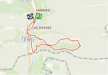
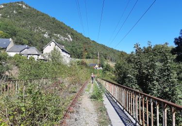
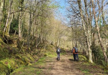
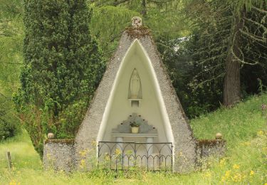
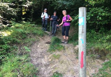
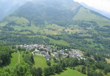
Randonnée Marche de 8,5 km à découvrir à Occitanie, Hautes-Pyrénées, Hèches. Cette randonnée est proposée par mitch1952.
Description
Randonnée effectuée en sens anti horaire , sens contraire du balisage local. Retour le long du canal de la Neste
Sortie commune du 17 juin 2022
Points d'intérêt
Localisation
Pays :
France
Région :
Occitanie
Département/Province :
Hautes-Pyrénées
Commune :
Hèches
Localité :
Unknown
Départ:(Dec)
Départ:(UTM)
286311 ; 4764239 (31T) N.
Commentaires
Randonnées à proximité
![Randonnée Marche Hèches - Rebouc G4 - Photo](https://media.geolcdn.com/t/375/260/6afd6a38-38b1-4921-be66-02c17ac9ac6f.jpg&format=jpg&maxdim=2)
![Marche Marche](https://static1.geolcdn.com/sitytour/trail-icons/101.png)
Rebouc G4
Marche
Très facile
Hèches,
Occitanie,
Hautes-Pyrénées,
France
![](/images/other/stat-length.png)
4,4 km | 5,9 km-effort
1h 10min
![](https://static1.geolcdn.com/siteimages/upload/files/16400158638029165_repeat_loop_refresh_sync_direction_icon.png)
Oui
![Randonnée Marche Esparros - FEU 2015 - Etape 3 - Photo](https://media.geolcdn.com/t/375/260/ext.jpg?maxdim=2&url=https%3A%2F%2Fstatic1.geolcdn.com%2Fsiteimages%2Fupload%2Ffiles%2F1553511878bg_sport_marche.png)
![Marche Marche](https://static1.geolcdn.com/sitytour/trail-icons/101.png)
FEU 2015 - Etape 3
Marche
Facile
(3)
Esparros,
Occitanie,
Hautes-Pyrénées,
France
![](/images/other/stat-length.png)
23 km | 32 km-effort
6h 45min
![](https://static1.geolcdn.com/siteimages/upload/files/16400158638029165_repeat_loop_refresh_sync_direction_icon.png)
Non
![Randonnée Marche Lortet - FEU 2015 - Etape 2 - Photo](https://media.geolcdn.com/t/375/260/ext.jpg?maxdim=2&url=https%3A%2F%2Fstatic1.geolcdn.com%2Fsiteimages%2Fupload%2Ffiles%2F1553511878bg_sport_marche.png)
![Marche Marche](https://static1.geolcdn.com/sitytour/trail-icons/101.png)
FEU 2015 - Etape 2
Marche
Facile
(1)
Lortet,
Occitanie,
Hautes-Pyrénées,
France
![](/images/other/stat-length.png)
7,8 km | 12,5 km-effort
2h 34min
![](https://static1.geolcdn.com/siteimages/upload/files/16400158638029165_repeat_loop_refresh_sync_direction_icon.png)
Non
![Randonnée Marche Esparros - Pacte des loups - Photo](https://media.geolcdn.com/t/375/260/ext.jpg?maxdim=2&url=https%3A%2F%2Fstatic1.geolcdn.com%2Fsiteimages%2Fupload%2Ffiles%2F1553511878bg_sport_marche.png)
![Marche Marche](https://static1.geolcdn.com/sitytour/trail-icons/101.png)
Pacte des loups
Marche
Moyen
(2)
Esparros,
Occitanie,
Hautes-Pyrénées,
France
![](/images/other/stat-length.png)
10,9 km | 18 km-effort
Inconnu
![](https://static1.geolcdn.com/siteimages/upload/files/16400158638029165_repeat_loop_refresh_sync_direction_icon.png)
Oui
![Randonnée Marche Hèches - REBOUC sortie commune LPC trace revue et corrigée](https://media.geolcdn.com/t/375/260/8e9dfb66-dcd3-4aee-b1eb-ee2219a413be.jpg&format=jpg&maxdim=2)
![Marche Marche](https://static1.geolcdn.com/sitytour/trail-icons/101.png)
REBOUC sortie commune LPC trace revue et corrigée "3822705"
Marche
Moyen
Hèches,
Occitanie,
Hautes-Pyrénées,
France
![](/images/other/stat-length.png)
6,1 km | 8,5 km-effort
1h 55min
![](https://static1.geolcdn.com/siteimages/upload/files/16400158638029165_repeat_loop_refresh_sync_direction_icon.png)
Oui
![Randonnée Marche Sarrancolin - plo de Berdaoulou - Photo](https://media.geolcdn.com/t/375/260/2313cc1f-dd1d-4b74-9e32-b9528b3e7a68.jpg&format=jpg&maxdim=2)
![Marche Marche](https://static1.geolcdn.com/sitytour/trail-icons/101.png)
plo de Berdaoulou
Marche
Moyen
Sarrancolin,
Occitanie,
Hautes-Pyrénées,
France
![](/images/other/stat-length.png)
12,9 km | 26 km-effort
7h 12min
![](https://static1.geolcdn.com/siteimages/upload/files/16400158638029165_repeat_loop_refresh_sync_direction_icon.png)
Oui
![Randonnée A pied Lortet - Voie d'Aure - Photo](https://media.geolcdn.com/t/375/260/34e6b7ee-1da4-4e0c-9a42-89afb2436ef7.jpeg&format=jpg&maxdim=2)
![A pied A pied](https://static1.geolcdn.com/sitytour/trail-icons/100.png)
Voie d'Aure
A pied
Très difficile
Lortet,
Occitanie,
Hautes-Pyrénées,
France
![](/images/other/stat-length.png)
56 km | 87 km-effort
19h 50min
![](https://static1.geolcdn.com/siteimages/upload/files/16400158638029165_repeat_loop_refresh_sync_direction_icon.png)
Non
![Randonnée Marche Esparros - Pacte des loups - Photo](https://media.geolcdn.com/t/375/260/c60a69e3-27b6-4618-8750-9159e2522e05.jpg&format=jpg&maxdim=2)
![Marche Marche](https://static1.geolcdn.com/sitytour/trail-icons/101.png)
Pacte des loups
Marche
Moyen
Esparros,
Occitanie,
Hautes-Pyrénées,
France
![](/images/other/stat-length.png)
7,8 km | 13,3 km-effort
5h 27min
![](https://static1.geolcdn.com/siteimages/upload/files/16400158638029165_repeat_loop_refresh_sync_direction_icon.png)
Oui
![Randonnée V.T.T. Sarrancolin - Le col d'Azet en VTT - Photo](https://media.geolcdn.com/t/375/260/ext.jpg?maxdim=2&url=https%3A%2F%2Fservices.sitytrail.com%2FGeolivesWS%2FDownloadMedia.ashx%3FTrailID%3D101155%26Media%3D645_4.jpg)
![V.T.T. V.T.T.](https://static1.geolcdn.com/sitytour/trail-icons/202.png)
Le col d'Azet en VTT
V.T.T.
Très difficile
Sarrancolin,
Occitanie,
Hautes-Pyrénées,
France
![](/images/other/stat-length.png)
28 km | 43 km-effort
2h 30min
![](https://static1.geolcdn.com/siteimages/upload/files/16400158638029165_repeat_loop_refresh_sync_direction_icon.png)
Non