![](/images/other/stat-length.png)
![Randonnée Marche Villaz - Découverte de Villaz - Photo](https://media.geolcdn.com/t/1900/400/ext.pjpeg?maxdim=2&url=https%3A%2F%2Fstatic1.geolcdn.com%2Fsiteimages%2Fupload%2Ffiles%2F1553511878bg_sport_marche.png)
Découverte de Villaz
COMAN
Utilisateur
![Longueur](/images/other/stat-length.png)
Longueur
5,7 km
![Altitude max](https://static1.geolcdn.com/siteimages/upload/files/1508320355ic_sort_altitude_max_24dp.png)
Altitude max
698 m
![Dénivelé positif](https://static1.geolcdn.com/siteimages/upload/files/1508320355ic_sort_den_pos_24dp.png)
Dénivelé positif
108 m
![Km-Effort](/images/other/stat-length.png)
Km-Effort
7,1 km
![Altitude min](https://static1.geolcdn.com/siteimages/upload/files/1508320355ic_sort_altitude_min_24dp.png)
Altitude min
599 m
![Dénivelé négatif](https://static1.geolcdn.com/siteimages/upload/files/1508320355ic_sort_den_neg_24dp.png)
Dénivelé négatif
108 m
![Boucle](https://static1.geolcdn.com/siteimages/upload/files/16400158638029165_repeat_loop_refresh_sync_direction_icon.png)
Boucle
Oui
Date de création :
2020-10-08 11:30:35.696
Dernière modification :
2020-10-08 11:41:23.981
![Marche](https://static1.geolcdn.com/sitytour/trail-icons/101.png)
1h48
Difficulté : Moyen
![Scannez ce code QR pour ouvrir la randonnée dans l'application SityTrail](https://capi.geolives.com/qq0zvz2zws4bq2lad0pu/sitytour/trails/2571485/qr.png?size=200)
Application GPS de randonnée GRATUITE
À propos
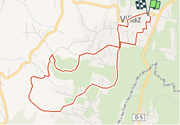
Randonnée Marche de 5,7 km à découvrir à Auvergne-Rhône-Alpes, Haute-Savoie, Villaz. Cette randonnée est proposée par COMAN.
Description
Depuis la salle polyvalente jusqu'aux vignes
Beaucoup de route
Découverte des nouveaux aménagements au tour du terrain de sport et des vignes
Localisation
Pays :
France
Région :
Auvergne-Rhône-Alpes
Département/Province :
Haute-Savoie
Commune :
Villaz
Localité :
Unknown
Départ:(Dec)
Départ:(UTM)
282580 ; 5092494 (32T) N.
Commentaires
Randonnées à proximité
![Randonnée Marche Fillière - LE PARMELAN: ANGLETTAZ - GRANDE GLACIERE - GROTTE DE L'ENFER - LAPIAZ - REFUGE... RETOUR PAR GRAND & PETIT MONTOIR - Photo](https://media.geolcdn.com/t/375/260/ext.jpg?maxdim=2&url=https%3A%2F%2Fmedia.geolcdn.com%2Ff%2F722005e2-5797-472c-b09d-da3e50a0e57d.jpg)
![Marche Marche](https://static1.geolcdn.com/sitytour/trail-icons/101.png)
LE PARMELAN: ANGLETTAZ - GRANDE GLACIERE - GROTTE DE L'ENFER - LAPIAZ - REFUG...
Marche
Difficile
(2)
Fillière,
Auvergne-Rhône-Alpes,
Haute-Savoie,
France
![](/images/other/stat-length.png)
9 km | 15,6 km-effort
4h 30min
![](https://static1.geolcdn.com/siteimages/upload/files/16400158638029165_repeat_loop_refresh_sync_direction_icon.png)
Oui
![Randonnée Marche Fillière - tour parmelan - Photo](https://media.geolcdn.com/t/375/260/ext.jpg?maxdim=2&url=https%3A%2F%2Fstatic1.geolcdn.com%2Fsiteimages%2Fupload%2Ffiles%2F1553511878bg_sport_marche.png)
![Marche Marche](https://static1.geolcdn.com/sitytour/trail-icons/101.png)
tour parmelan
Marche
Facile
(2)
Fillière,
Auvergne-Rhône-Alpes,
Haute-Savoie,
France
![](/images/other/stat-length.png)
12,9 km | 22 km-effort
4h 0min
![](https://static1.geolcdn.com/siteimages/upload/files/16400158638029165_repeat_loop_refresh_sync_direction_icon.png)
Oui
![Randonnée Marche Fillière - chalet de l'angletaz pour Umi - Photo](https://media.geolcdn.com/t/375/260/ext.jpg?maxdim=2&url=https%3A%2F%2Fmedia.geolcdn.com%2Ff%2F31a59abd-fd5f-44b3-890d-ba2d03dc72c1.jpg)
![Marche Marche](https://static1.geolcdn.com/sitytour/trail-icons/101.png)
chalet de l'angletaz pour Umi
Marche
Facile
Fillière,
Auvergne-Rhône-Alpes,
Haute-Savoie,
France
![](/images/other/stat-length.png)
3,8 km | 5,7 km-effort
1h 11min
![](https://static1.geolcdn.com/siteimages/upload/files/16400158638029165_repeat_loop_refresh_sync_direction_icon.png)
Oui
![Randonnée Marche Fillière - refuge Patmelan via anglettaz . gd glacière . fontaine du tour . grotte de l enfer / retour via gd montoir et pt montoir - Photo](https://media.geolcdn.com/t/375/260/ext.jpg?maxdim=2&url=https%3A%2F%2Fmedia.geolcdn.com%2Ff%2Fd9aff979-a700-421f-a6a0-6747275eea2c.jpg)
![Marche Marche](https://static1.geolcdn.com/sitytour/trail-icons/101.png)
refuge Patmelan via anglettaz . gd glacière . fontaine du tour . grotte de l ...
Marche
Moyen
Fillière,
Auvergne-Rhône-Alpes,
Haute-Savoie,
France
![](/images/other/stat-length.png)
10,2 km | 16,1 km-effort
6h 1min
![](https://static1.geolcdn.com/siteimages/upload/files/16400158638029165_repeat_loop_refresh_sync_direction_icon.png)
Oui
![Randonnée Marche Fillière - LE PARMELAN: ANGLETTAZ - GRANDE GLACIERE -](https://media.geolcdn.com/t/375/260/ext.jpg?maxdim=2&url=https%3A%2F%2Fmedia.geolcdn.com%2Ff%2F1a67916c-32da-4c49-ba0d-07b010a4e013.jpg)
![Marche Marche](https://static1.geolcdn.com/sitytour/trail-icons/101.png)
LE PARMELAN: ANGLETTAZ - GRANDE GLACIERE - "LES LAPIAZ" - REFUGE DU PARMELAN ...
Marche
Moyen
Fillière,
Auvergne-Rhône-Alpes,
Haute-Savoie,
France
![](/images/other/stat-length.png)
9,4 km | 14,5 km-effort
4h 35min
![](https://static1.geolcdn.com/siteimages/upload/files/16400158638029165_repeat_loop_refresh_sync_direction_icon.png)
Oui
![Randonnée Marche Annecy - course avec tobias - Photo](https://media.geolcdn.com/t/375/260/ext.jpg?maxdim=2&url=https%3A%2F%2Fmedia.geolcdn.com%2Ff%2F5511a080-8bbf-4e35-a1e7-eb6c019b0144.jpg)
![Marche Marche](https://static1.geolcdn.com/sitytour/trail-icons/101.png)
course avec tobias
Marche
Moyen
Annecy,
Auvergne-Rhône-Alpes,
Haute-Savoie,
France
![](/images/other/stat-length.png)
9,9 km | 13,7 km-effort
1h 40min
![](https://static1.geolcdn.com/siteimages/upload/files/16400158638029165_repeat_loop_refresh_sync_direction_icon.png)
Oui
![Randonnée A pied Dingy-Saint-Clair - PR Boucle du Parmelan - Photo](https://media.geolcdn.com/t/375/260/ext.jpg?maxdim=2&url=https%3A%2F%2Fmedia.geolcdn.com%2Ff%2F6f92a529-84d8-4dac-bcdf-47427f9f0956.jpeg)
![A pied A pied](https://static1.geolcdn.com/sitytour/trail-icons/100.png)
PR Boucle du Parmelan
A pied
Moyen
Dingy-Saint-Clair,
Auvergne-Rhône-Alpes,
Haute-Savoie,
France
![](/images/other/stat-length.png)
11,3 km | 25 km-effort
5h 38min
![](https://static1.geolcdn.com/siteimages/upload/files/16400158638029165_repeat_loop_refresh_sync_direction_icon.png)
Non
![Randonnée Marche Fillière - Tete du Parmelan - Photo](https://media.geolcdn.com/t/375/260/ext.jpg?maxdim=2&url=https%3A%2F%2Fmedia.geolcdn.com%2Ff%2Fe502a722-32d6-4592-b868-3c83d0cfe463.jpg)
![Marche Marche](https://static1.geolcdn.com/sitytour/trail-icons/101.png)
Tete du Parmelan
Marche
Difficile
Fillière,
Auvergne-Rhône-Alpes,
Haute-Savoie,
France
![](/images/other/stat-length.png)
14,9 km | 26 km-effort
7h 15min
![](https://static1.geolcdn.com/siteimages/upload/files/16400158638029165_repeat_loop_refresh_sync_direction_icon.png)
Oui
![Randonnée Autre activité Annecy - Petit guide - Photo](https://media.geolcdn.com/t/375/260/ext.jpg?maxdim=2&url=https%3A%2F%2Fstatic1.geolcdn.com%2Fsiteimages%2Fupload%2Ffiles%2F1545311037marcheuse_200dpi.jpg)
![Autre activité Autre activité](https://static1.geolcdn.com/sitytour/trail-icons/900.png)
Petit guide
Autre activité
Très facile
(1)
Annecy,
Auvergne-Rhône-Alpes,
Haute-Savoie,
France
![](/images/other/stat-length.png)
9,1 km | 14 km-effort
1h 40min
![](https://static1.geolcdn.com/siteimages/upload/files/16400158638029165_repeat_loop_refresh_sync_direction_icon.png)
Oui