![](/images/other/stat-length.png)
![Randonnée Marche Diepenbeek - Diepenbeek - Photo](https://media.geolcdn.com/t/1900/400/01eb599c-386f-4b0d-b162-ae9d112c9ebf.jpg&format=pjpeg&maxdim=2)
Diepenbeek
mumu.larandonneuse
Utilisateur GUIDE
![Longueur](/images/other/stat-length.png)
Longueur
18,9 km
![Altitude max](https://static1.geolcdn.com/siteimages/upload/files/1508320355ic_sort_altitude_max_24dp.png)
Altitude max
47 m
![Dénivelé positif](https://static1.geolcdn.com/siteimages/upload/files/1508320355ic_sort_den_pos_24dp.png)
Dénivelé positif
114 m
![Km-Effort](/images/other/stat-length.png)
Km-Effort
20 km
![Altitude min](https://static1.geolcdn.com/siteimages/upload/files/1508320355ic_sort_altitude_min_24dp.png)
Altitude min
30 m
![Dénivelé négatif](https://static1.geolcdn.com/siteimages/upload/files/1508320355ic_sort_den_neg_24dp.png)
Dénivelé négatif
114 m
![Boucle](https://static1.geolcdn.com/siteimages/upload/files/16400158638029165_repeat_loop_refresh_sync_direction_icon.png)
Boucle
Oui
Date de création :
2020-10-07 08:19:50.295
Dernière modification :
2020-10-16 15:04:54.115
![Marche](https://static1.geolcdn.com/sitytour/trail-icons/101.png)
3h49
Difficulté : Très facile
![Scannez ce code QR pour ouvrir la randonnée dans l'application SityTrail](https://capi.geolives.com/qq0zvz2zws4bq2lad0pu/sitytour/trails/2570727/qr.png?size=200)
Application GPS de randonnée GRATUITE
À propos
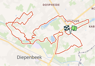
Randonnée Marche de 18,9 km à découvrir à Flandre, Limbourg, Diepenbeek. Cette randonnée est proposée par mumu.larandonneuse.
Description
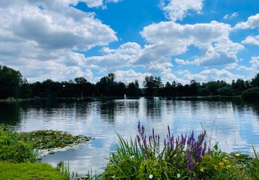
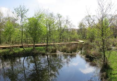
Belle randonnée sans difficulté et chemins diversifiés.
D/A : Parking Onze Lieve Vrouwstraat 22 à Diepenbeek.
Parcours de 12 km possible sans faire la boucle après le complexe sportif. Après le petit pont, tourner directement à droite le long de l'eau.
Localisation
Pays :
Belgique
Région :
Flandre
Département/Province :
Limbourg
Commune :
Diepenbeek
Localité :
Diepenbeek
Départ:(Dec)
Départ:(UTM)
671992 ; 5643488 (31U) N.
Commentaires
Randonnées à proximité
![Randonnée Marche Genk - Promenade vers la piste dans l'eau, dans le magnifique domaine de Bokrijk - Photo](https://media.geolcdn.com/t/375/260/45cc0ed2-db94-4d5d-a7c6-1096a930a2ab.jpg&format=jpg&maxdim=2)
![Marche Marche](https://static1.geolcdn.com/sitytour/trail-icons/101.png)
Promenade vers la piste dans l'eau, dans le magnifique domaine de Bokrijk
Marche
Facile
(3)
Genk,
Flandre,
Limbourg,
Belgique
![](/images/other/stat-length.png)
4,1 km | 4,6 km-effort
1h 2min
![](https://static1.geolcdn.com/siteimages/upload/files/16400158638029165_repeat_loop_refresh_sync_direction_icon.png)
Oui
![Randonnée Marche Diepenbeek - La vallée du Démer - La réserve naturelle Dorpsbemden à Diepenbeek - Photo](https://media.geolcdn.com/t/375/260/831c90b3-6b69-4442-bd2d-357552ece2e5.jpeg&format=jpg&maxdim=2)
![Marche Marche](https://static1.geolcdn.com/sitytour/trail-icons/101.png)
La vallée du Démer - La réserve naturelle Dorpsbemden à Diepenbeek
Marche
Facile
Diepenbeek,
Flandre,
Limbourg,
Belgique
![](/images/other/stat-length.png)
3,1 km | 3,3 km-effort
45min
![](https://static1.geolcdn.com/siteimages/upload/files/16400158638029165_repeat_loop_refresh_sync_direction_icon.png)
Oui
![Randonnée Marche Diepenbeek - La vallée du Démer - Le ruisseau Dauten et les Dautewijers à Diepenbeek - Photo](https://media.geolcdn.com/t/375/260/ff431e14-a2e4-4401-9193-e96799f79a9a.jpeg&format=jpg&maxdim=2)
![Marche Marche](https://static1.geolcdn.com/sitytour/trail-icons/101.png)
La vallée du Démer - Le ruisseau Dauten et les Dautewijers à Diepenbeek
Marche
Facile
Diepenbeek,
Flandre,
Limbourg,
Belgique
![](/images/other/stat-length.png)
5,4 km | 5,8 km-effort
1h 19min
![](https://static1.geolcdn.com/siteimages/upload/files/16400158638029165_repeat_loop_refresh_sync_direction_icon.png)
Oui
![Randonnée A pied Diepenbeek - Lange afstandstocht - Photo](https://media.geolcdn.com/t/375/260/c0f28296-bcff-4fe2-9db4-902c2464ce24.jpeg&format=jpg&maxdim=2)
![A pied A pied](https://static1.geolcdn.com/sitytour/trail-icons/100.png)
Lange afstandstocht
A pied
Facile
Diepenbeek,
Flandre,
Limbourg,
Belgique
![](/images/other/stat-length.png)
16,5 km | 17,8 km-effort
4h 2min
![](https://static1.geolcdn.com/siteimages/upload/files/16400158638029165_repeat_loop_refresh_sync_direction_icon.png)
Oui
![Randonnée A pied Genk - Zillebos blauwe ruit - Photo](https://media.geolcdn.com/t/375/260/6925453e-2323-4e41-8380-50ced4fee93a.jpeg&format=jpg&maxdim=2)
![A pied A pied](https://static1.geolcdn.com/sitytour/trail-icons/100.png)
Zillebos blauwe ruit
A pied
Facile
Genk,
Flandre,
Limbourg,
Belgique
![](/images/other/stat-length.png)
4,2 km | 4,9 km-effort
1h 7min
![](https://static1.geolcdn.com/siteimages/upload/files/16400158638029165_repeat_loop_refresh_sync_direction_icon.png)
Oui
![Randonnée A pied Genk - Zillebos rode driehoek - Photo](https://media.geolcdn.com/t/375/260/6925453e-2323-4e41-8380-50ced4fee93a.jpeg&format=jpg&maxdim=2)
![A pied A pied](https://static1.geolcdn.com/sitytour/trail-icons/100.png)
Zillebos rode driehoek
A pied
Facile
Genk,
Flandre,
Limbourg,
Belgique
![](/images/other/stat-length.png)
5,5 km | 6,4 km-effort
1h 27min
![](https://static1.geolcdn.com/siteimages/upload/files/16400158638029165_repeat_loop_refresh_sync_direction_icon.png)
Oui
![Randonnée A pied Genk - De Maten oranje - Photo](https://media.geolcdn.com/t/375/260/5daa36df-5a45-46f0-9e87-234b3c303469.jpeg&format=jpg&maxdim=2)
![A pied A pied](https://static1.geolcdn.com/sitytour/trail-icons/100.png)
![Randonnée A pied Hasselt - Kiewit Wildernis route - Photo](https://media.geolcdn.com/t/375/260/3dbc744d-9453-4105-ac17-d803e722e0e9.jpeg&format=jpg&maxdim=2)
![A pied A pied](https://static1.geolcdn.com/sitytour/trail-icons/100.png)
Kiewit Wildernis route
A pied
Facile
Hasselt,
Flandre,
Limbourg,
Belgique
![](/images/other/stat-length.png)
3,3 km | 3,7 km-effort
49min
![](https://static1.geolcdn.com/siteimages/upload/files/16400158638029165_repeat_loop_refresh_sync_direction_icon.png)
Oui
![Randonnée A pied Hasselt - Kiewit Wijer route - Photo](https://media.geolcdn.com/t/375/260/3dbc744d-9453-4105-ac17-d803e722e0e9.jpeg&format=jpg&maxdim=2)
![A pied A pied](https://static1.geolcdn.com/sitytour/trail-icons/100.png)
Kiewit Wijer route
A pied
Facile
Hasselt,
Flandre,
Limbourg,
Belgique
![](/images/other/stat-length.png)
4,1 km | 4,6 km-effort
1h 3min
![](https://static1.geolcdn.com/siteimages/upload/files/16400158638029165_repeat_loop_refresh_sync_direction_icon.png)
Oui