![](/images/other/stat-length.png)
![Randonnée Marche Saint-Tropez - PRESQU'ÎLE DE SAINT TROPEZ - Photo](https://media.geolcdn.com/t/1900/400/8e598ed1-ea67-4611-be57-9e4f5043f112.jpg&format=pjpeg&maxdim=2)
PRESQU'ÎLE DE SAINT TROPEZ
jean-marie.parachini
Utilisateur
![Longueur](/images/other/stat-length.png)
Longueur
12,2 km
![Altitude max](https://static1.geolcdn.com/siteimages/upload/files/1508320355ic_sort_altitude_max_24dp.png)
Altitude max
90 m
![Dénivelé positif](https://static1.geolcdn.com/siteimages/upload/files/1508320355ic_sort_den_pos_24dp.png)
Dénivelé positif
192 m
![Km-Effort](/images/other/stat-length.png)
Km-Effort
14,7 km
![Altitude min](https://static1.geolcdn.com/siteimages/upload/files/1508320355ic_sort_altitude_min_24dp.png)
Altitude min
0 m
![Dénivelé négatif](https://static1.geolcdn.com/siteimages/upload/files/1508320355ic_sort_den_neg_24dp.png)
Dénivelé négatif
191 m
![Boucle](https://static1.geolcdn.com/siteimages/upload/files/16400158638029165_repeat_loop_refresh_sync_direction_icon.png)
Boucle
Oui
Date de création :
2020-10-06 07:39:52.442
Dernière modification :
2020-10-06 18:08:34.135
![Marche](https://static1.geolcdn.com/sitytour/trail-icons/101.png)
5h19
Difficulté : Moyen
![Scannez ce code QR pour ouvrir la randonnée dans l'application SityTrail](https://capi.geolives.com/qq0zvz2zws4bq2lad0pu/sitytour/trails/2570225/qr.png?size=200)
Application GPS de randonnée GRATUITE
À propos
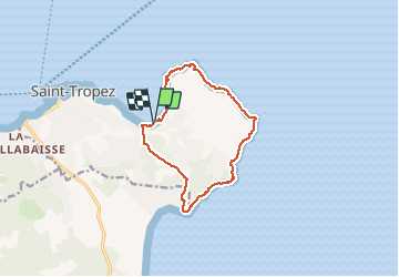
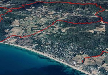
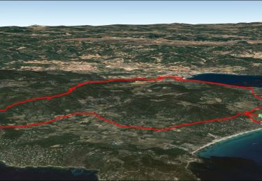
Randonnée Marche de 12,2 km à découvrir à Provence-Alpes-Côte d'Azur, Var, Saint-Tropez. Cette randonnée est proposée par jean-marie.parachini.
Description
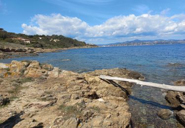
circuit de la baie des Canebiers vers pointe de la Rabiou cap de Saint-Tropez cap des Salins pointe de Capon cap du Pinet et retour à baie des Canebiers par Capon.
Localisation
Pays :
France
Région :
Provence-Alpes-Côte d'Azur
Département/Province :
Var
Commune :
Saint-Tropez
Localité :
Unknown
Départ:(Dec)
Départ:(UTM)
310570 ; 4792912 (32T) N.
Commentaires
Randonnées à proximité
![Randonnée Marche Saint-Tropez - Saint Tropez - Photo](https://media.geolcdn.com/t/375/260/ext.jpg?maxdim=2&url=https%3A%2F%2Fservices.sitytrail.com%2FGeolivesWS%2FDownloadMedia.ashx%3FTrailID%3D636110%26Media%3Dfix__20160925112927.jpg)
![Marche Marche](https://static1.geolcdn.com/sitytour/trail-icons/101.png)
Saint Tropez
Marche
Facile
(1)
Saint-Tropez,
Provence-Alpes-Côte d'Azur,
Var,
France
![](/images/other/stat-length.png)
11,7 km | 13,7 km-effort
4h 19min
![](https://static1.geolcdn.com/siteimages/upload/files/16400158638029165_repeat_loop_refresh_sync_direction_icon.png)
Non
![Randonnée Marche Ramatuelle - chemin du littoral : Pampelone St Tropez - Photo](https://media.geolcdn.com/t/375/260/ext.jpg?maxdim=2&url=https%3A%2F%2Fservices.sitytrail.com%2FGeolivesWS%2FDownloadMedia.ashx%3FTrailID%3D200480%26Media%3D20130625091922.jpeg)
![Marche Marche](https://static1.geolcdn.com/sitytour/trail-icons/101.png)
chemin du littoral : Pampelone St Tropez
Marche
Facile
(3)
Ramatuelle,
Provence-Alpes-Côte d'Azur,
Var,
France
![](/images/other/stat-length.png)
13,2 km | 15,6 km-effort
3h 20min
![](https://static1.geolcdn.com/siteimages/upload/files/16400158638029165_repeat_loop_refresh_sync_direction_icon.png)
Non
![Randonnée Marche Saint-Tropez - Golfe de St Tropez - Photo](https://media.geolcdn.com/t/375/260/ext.jpg?maxdim=2&url=https%3A%2F%2Fservices.sitytrail.com%2FGeolivesWS%2FDownloadMedia.ashx%3FTrailID%3D107154%26Media%3D11997_5.jpg)
![Marche Marche](https://static1.geolcdn.com/sitytour/trail-icons/101.png)
Golfe de St Tropez
Marche
Difficile
(2)
Saint-Tropez,
Provence-Alpes-Côte d'Azur,
Var,
France
![](/images/other/stat-length.png)
15,1 km | 17,6 km-effort
4h 30min
![](https://static1.geolcdn.com/siteimages/upload/files/16400158638029165_repeat_loop_refresh_sync_direction_icon.png)
Oui
![Randonnée Marche Saint-Tropez - St tropez calanque - Photo](https://media.geolcdn.com/t/375/260/3af67e6c-107d-484e-b13a-cf0edd584740.jpg&format=jpg&maxdim=2)
![Marche Marche](https://static1.geolcdn.com/sitytour/trail-icons/101.png)
St tropez calanque
Marche
Moyen
(1)
Saint-Tropez,
Provence-Alpes-Côte d'Azur,
Var,
France
![](/images/other/stat-length.png)
9,9 km | 11,4 km-effort
3h 52min
![](https://static1.geolcdn.com/siteimages/upload/files/16400158638029165_repeat_loop_refresh_sync_direction_icon.png)
Oui
![Randonnée V.T.T. Ramatuelle - VTT - Ramatuelle - Ballade dans et autour de Ramatuelle - Moulin de Paillas - La roulliere - Photo](https://media.geolcdn.com/t/375/260/ext.jpg?maxdim=2&url=https%3A%2F%2Fstatic1.geolcdn.com%2Fsiteimages%2Fupload%2Ffiles%2F1524743154velo.jpg)
![V.T.T. V.T.T.](https://static1.geolcdn.com/sitytour/trail-icons/202.png)
VTT - Ramatuelle - Ballade dans et autour de Ramatuelle - Moulin de Paillas -...
V.T.T.
Moyen
(1)
Ramatuelle,
Provence-Alpes-Côte d'Azur,
Var,
France
![](/images/other/stat-length.png)
23 km | 30 km-effort
2h 3min
![](https://static1.geolcdn.com/siteimages/upload/files/16400158638029165_repeat_loop_refresh_sync_direction_icon.png)
Oui
![Vélo électrique Vélo électrique](https://static1.geolcdn.com/sitytour/trail-icons/205.png)
VTT-AE - Mataranne - Bonne Terrasse - Camarat - Collebasse - paillas.
Vélo électrique
Moyen
Ramatuelle,
Provence-Alpes-Côte d'Azur,
Var,
France
![](/images/other/stat-length.png)
33 km | 43 km-effort
3h 0min
![](https://static1.geolcdn.com/siteimages/upload/files/16400158638029165_repeat_loop_refresh_sync_direction_icon.png)
Oui
![V.T.T. V.T.T.](https://static1.geolcdn.com/sitytour/trail-icons/202.png)
VTT Mataranne - Paillas - Gassin - St Tropez
V.T.T.
Moyen
Ramatuelle,
Provence-Alpes-Côte d'Azur,
Var,
France
![](/images/other/stat-length.png)
30 km | 37 km-effort
3h 0min
![](https://static1.geolcdn.com/siteimages/upload/files/16400158638029165_repeat_loop_refresh_sync_direction_icon.png)
Oui
![Randonnée Marche Saint-Tropez - St Tropez littoral - Photo](https://media.geolcdn.com/t/375/260/072b31b2-52f6-4dca-a49f-5baffe5c7dc9.jpg&format=jpg&maxdim=2)
![Marche Marche](https://static1.geolcdn.com/sitytour/trail-icons/101.png)
St Tropez littoral
Marche
Moyen
Saint-Tropez,
Provence-Alpes-Côte d'Azur,
Var,
France
![](/images/other/stat-length.png)
18,3 km | 22 km-effort
6h 3min
![](https://static1.geolcdn.com/siteimages/upload/files/16400158638029165_repeat_loop_refresh_sync_direction_icon.png)
Oui
![Randonnée Bateau à moteur Saint-Tropez - Nalade St Tropez bateau - Photo](https://media.geolcdn.com/t/375/260/254f135f-2379-4ae8-9362-6a2064aa074d.jpg&format=jpg&maxdim=2)
![Bateau à moteur Bateau à moteur](https://static1.geolcdn.com/sitytour/trail-icons/701.png)
Nalade St Tropez bateau
Bateau à moteur
Très facile
Saint-Tropez,
Provence-Alpes-Côte d'Azur,
Var,
France
![](/images/other/stat-length.png)
18,2 km | 18,3 km-effort
1h 7min
![](https://static1.geolcdn.com/siteimages/upload/files/16400158638029165_repeat_loop_refresh_sync_direction_icon.png)
Oui