![](/images/other/stat-length.png)
![Randonnée Marche Belvédère - Le Grand Capelet - Photo](https://media.geolcdn.com/t/1900/400/ext.pjpeg?maxdim=2&url=https%3A%2F%2Fstatic1.geolcdn.com%2Fsiteimages%2Fupload%2Ffiles%2F1553511878bg_sport_marche.png)
Le Grand Capelet
bozo1970
Utilisateur
![Longueur](/images/other/stat-length.png)
Longueur
16,2 km
![Altitude max](https://static1.geolcdn.com/siteimages/upload/files/1508320355ic_sort_altitude_max_24dp.png)
Altitude max
2909 m
![Dénivelé positif](https://static1.geolcdn.com/siteimages/upload/files/1508320355ic_sort_den_pos_24dp.png)
Dénivelé positif
1804 m
![Km-Effort](/images/other/stat-length.png)
Km-Effort
40 km
![Altitude min](https://static1.geolcdn.com/siteimages/upload/files/1508320355ic_sort_altitude_min_24dp.png)
Altitude min
1684 m
![Dénivelé négatif](https://static1.geolcdn.com/siteimages/upload/files/1508320355ic_sort_den_neg_24dp.png)
Dénivelé négatif
1805 m
![Boucle](https://static1.geolcdn.com/siteimages/upload/files/16400158638029165_repeat_loop_refresh_sync_direction_icon.png)
Boucle
Oui
Date de création :
2020-10-01 07:19:28.0
Dernière modification :
2020-10-02 06:39:47.911
![Marche](https://static1.geolcdn.com/sitytour/trail-icons/101.png)
8h37
Difficulté : Très difficile
![Scannez ce code QR pour ouvrir la randonnée dans l'application SityTrail](https://capi.geolives.com/qq0zvz2zws4bq2lad0pu/sitytour/trails/2566330/qr.png?size=200)
Application GPS de randonnée GRATUITE
À propos
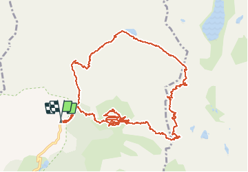
Randonnée Marche de 16,2 km à découvrir à Provence-Alpes-Côte d'Azur, Alpes-Maritimes, Belvédère. Cette randonnée est proposée par bozo1970.
Description
En boucle
Montée par le pas des Conques
Descente par la baisse de l'Autier
passage impossible dans les barres sous le pas
Aucune visibilité au sommet
Descente sur la baisse de l'Autier simplement féérique
16 km, 8h30 et D 1800m
Localisation
Pays :
France
Région :
Provence-Alpes-Côte d'Azur
Département/Province :
Alpes-Maritimes
Commune :
Belvédère
Localité :
Unknown
Départ:(Dec)
Départ:(UTM)
371873 ; 4881318 (32T) N.
Commentaires
Randonnées à proximité
![Randonnée A pied Saint-Martin-Vésubie - Lacs de Prals - Photo](https://media.geolcdn.com/t/375/260/ext.jpg?maxdim=2&url=https%3A%2F%2Fstatic1.geolcdn.com%2Fsiteimages%2Fupload%2Ffiles%2F1545311037marcheuse_200dpi.jpg)
![A pied A pied](https://static1.geolcdn.com/sitytour/trail-icons/100.png)
Lacs de Prals
A pied
Facile
(1)
Saint-Martin-Vésubie,
Provence-Alpes-Côte d'Azur,
Alpes-Maritimes,
France
![](/images/other/stat-length.png)
6,7 km | 13,6 km-effort
3h 5min
![](https://static1.geolcdn.com/siteimages/upload/files/16400158638029165_repeat_loop_refresh_sync_direction_icon.png)
Oui
![Randonnée Marche Saint-Martin-Vésubie - Boucle Les lacs de Prals par la cime de la Vallette - Photo](https://media.geolcdn.com/t/375/260/2c298eac-1e8e-4f8d-83e4-c08337da9759.jpg&format=jpg&maxdim=2)
![Marche Marche](https://static1.geolcdn.com/sitytour/trail-icons/101.png)
Boucle Les lacs de Prals par la cime de la Vallette
Marche
Très difficile
Saint-Martin-Vésubie,
Provence-Alpes-Côte d'Azur,
Alpes-Maritimes,
France
![](/images/other/stat-length.png)
13,2 km | 24 km-effort
4h 50min
![](https://static1.geolcdn.com/siteimages/upload/files/16400158638029165_repeat_loop_refresh_sync_direction_icon.png)
Oui
![Randonnée A pied Tende - Tour du Grand Capelet - Etape 3 - Photo](https://media.geolcdn.com/t/375/260/67c778a0-1b6d-4c3c-80c3-0c64750da270.jpeg&format=jpg&maxdim=2)
![A pied A pied](https://static1.geolcdn.com/sitytour/trail-icons/100.png)
Tour du Grand Capelet - Etape 3
A pied
Facile
Tende,
Provence-Alpes-Côte d'Azur,
Alpes-Maritimes,
France
![](/images/other/stat-length.png)
6,4 km | 12,9 km-effort
2h 56min
![](https://static1.geolcdn.com/siteimages/upload/files/16400158638029165_repeat_loop_refresh_sync_direction_icon.png)
Non
![Randonnée A pied Belvédère - Les Merveilles par la Gordolasque - Photo](https://media.geolcdn.com/t/375/260/530d04a7-b615-4962-acf5-9f79fcad8eda.jpeg&format=jpg&maxdim=2)
![A pied A pied](https://static1.geolcdn.com/sitytour/trail-icons/100.png)
Les Merveilles par la Gordolasque
A pied
Moyen
Belvédère,
Provence-Alpes-Côte d'Azur,
Alpes-Maritimes,
France
![](/images/other/stat-length.png)
13 km | 29 km-effort
6h 35min
![](https://static1.geolcdn.com/siteimages/upload/files/16400158638029165_repeat_loop_refresh_sync_direction_icon.png)
Oui
![Randonnée A pied Saint-Martin-Vésubie - Circuit de Fenestre - Photo](https://media.geolcdn.com/t/375/260/2f55aaab-545e-409a-9c6e-8c2e9c42d8aa.jpeg&format=jpg&maxdim=2)
![A pied A pied](https://static1.geolcdn.com/sitytour/trail-icons/100.png)
Circuit de Fenestre
A pied
Facile
Saint-Martin-Vésubie,
Provence-Alpes-Côte d'Azur,
Alpes-Maritimes,
France
![](/images/other/stat-length.png)
8,1 km | 16,4 km-effort
3h 44min
![](https://static1.geolcdn.com/siteimages/upload/files/16400158638029165_repeat_loop_refresh_sync_direction_icon.png)
Oui
![Marche Marche](https://static1.geolcdn.com/sitytour/trail-icons/101.png)
Lac Autier par le refuge de Nice
Marche
Très difficile
Belvédère,
Provence-Alpes-Côte d'Azur,
Alpes-Maritimes,
France
![](/images/other/stat-length.png)
13 km | 25 km-effort
5h 4min
![](https://static1.geolcdn.com/siteimages/upload/files/16400158638029165_repeat_loop_refresh_sync_direction_icon.png)
Oui
![Randonnée Marche Belvédère - Refuge de Nice le Lac Autier - Photo](https://media.geolcdn.com/t/375/260/90f5472c-c83a-4f85-b43b-3f70801c497f.jpg&format=jpg&maxdim=2)
![Marche Marche](https://static1.geolcdn.com/sitytour/trail-icons/101.png)
Refuge de Nice le Lac Autier
Marche
Très difficile
Belvédère,
Provence-Alpes-Côte d'Azur,
Alpes-Maritimes,
France
![](/images/other/stat-length.png)
8,4 km | 16,4 km-effort
5h 1min
![](https://static1.geolcdn.com/siteimages/upload/files/16400158638029165_repeat_loop_refresh_sync_direction_icon.png)
Non
![Randonnée Marche Belvédère - Pont du Countet refuge de Nice et Lacs du Mont Clapier - Photo](https://media.geolcdn.com/t/375/260/e630815b-37c0-4f3c-a885-04147e40707a.jpg&format=jpg&maxdim=2)
![Marche Marche](https://static1.geolcdn.com/sitytour/trail-icons/101.png)
Pont du Countet refuge de Nice et Lacs du Mont Clapier
Marche
Difficile
Belvédère,
Provence-Alpes-Côte d'Azur,
Alpes-Maritimes,
France
![](/images/other/stat-length.png)
8,1 km | 18,1 km-effort
4h 1min
![](https://static1.geolcdn.com/siteimages/upload/files/16400158638029165_repeat_loop_refresh_sync_direction_icon.png)
Non
![Randonnée Marche Saint-Martin-Vésubie - Lacs de Prals - Photo](https://media.geolcdn.com/t/375/260/ext.jpg?maxdim=2&url=https%3A%2F%2Fservices.sitytrail.com%2FGeolivesWS%2FDownloadMedia.ashx%3FTrailID%3D452352%26Media%3D84506a50-74df-4ea2-b935-71761b13f9a6.jpg)
![Marche Marche](https://static1.geolcdn.com/sitytour/trail-icons/101.png)
Lacs de Prals
Marche
Facile
(1)
Saint-Martin-Vésubie,
Provence-Alpes-Côte d'Azur,
Alpes-Maritimes,
France
![](/images/other/stat-length.png)
6,7 km | 13,5 km-effort
2h 48min
![](https://static1.geolcdn.com/siteimages/upload/files/16400158638029165_repeat_loop_refresh_sync_direction_icon.png)
Oui