![](/images/other/stat-length.png)
![Randonnée Marche Sospel - De Sospel à Piène Haute - Photo](https://media.geolcdn.com/t/1900/400/ext.pjpeg?maxdim=2&url=https%3A%2F%2Fstatic1.geolcdn.com%2Fsiteimages%2Fupload%2Ffiles%2F1553511878bg_sport_marche.png)
De Sospel à Piène Haute
jlrayon
Utilisateur
![Longueur](/images/other/stat-length.png)
Longueur
15,9 km
![Altitude max](https://static1.geolcdn.com/siteimages/upload/files/1508320355ic_sort_altitude_max_24dp.png)
Altitude max
755 m
![Dénivelé positif](https://static1.geolcdn.com/siteimages/upload/files/1508320355ic_sort_den_pos_24dp.png)
Dénivelé positif
828 m
![Km-Effort](/images/other/stat-length.png)
Km-Effort
27 km
![Altitude min](https://static1.geolcdn.com/siteimages/upload/files/1508320355ic_sort_altitude_min_24dp.png)
Altitude min
283 m
![Dénivelé négatif](https://static1.geolcdn.com/siteimages/upload/files/1508320355ic_sort_den_neg_24dp.png)
Dénivelé négatif
833 m
![Boucle](https://static1.geolcdn.com/siteimages/upload/files/16400158638029165_repeat_loop_refresh_sync_direction_icon.png)
Boucle
Oui
Date de création :
2014-12-10 00:00:00.0
Dernière modification :
2014-12-10 00:00:00.0
![Marche](https://static1.geolcdn.com/sitytour/trail-icons/101.png)
5h24
Difficulté : Moyen
![Scannez ce code QR pour ouvrir la randonnée dans l'application SityTrail](https://capi.geolives.com/qq0zvz2zws4bq2lad0pu/sitytour/trails/256342/qr.png?size=200)
Application GPS de randonnée GRATUITE
À propos
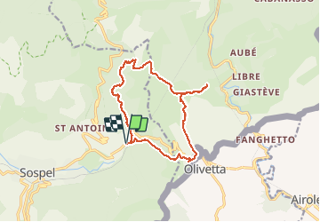
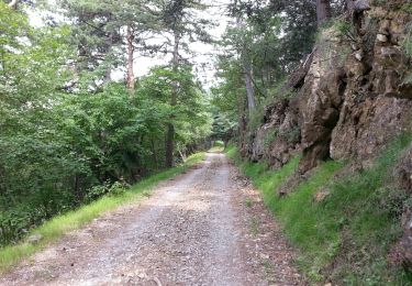
Randonnée Marche de 15,9 km à découvrir à Provence-Alpes-Côte d'Azur, Alpes-Maritimes, Sospel. Cette randonnée est proposée par jlrayon.
Description
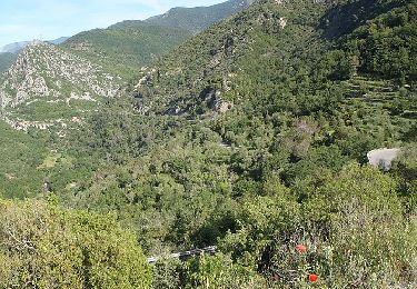
Belle balade autour du mont Grazian par la vallée du Caï, la vallée de Basséra, le Col de Paula, escale à Piène Haute. Retour par Olivetta et le Sentier Botanique.
Localisation
Pays :
France
Région :
Provence-Alpes-Côte d'Azur
Département/Province :
Alpes-Maritimes
Commune :
Sospel
Localité :
Unknown
Départ:(Dec)
Départ:(UTM)
378244 ; 4860405 (32T) N.
Commentaires
Randonnées à proximité
![Randonnée A pied Breil-sur-Roya - Circuit de Libre - Photo](https://media.geolcdn.com/t/375/260/dcdab34e-1af6-4915-900a-fc3842fda859.jpeg&format=jpg&maxdim=2)
![A pied A pied](https://static1.geolcdn.com/sitytour/trail-icons/100.png)
Circuit de Libre
A pied
Facile
Breil-sur-Roya,
Provence-Alpes-Côte d'Azur,
Alpes-Maritimes,
France
![](/images/other/stat-length.png)
7 km | 14 km-effort
3h 10min
![](https://static1.geolcdn.com/siteimages/upload/files/16400158638029165_repeat_loop_refresh_sync_direction_icon.png)
Oui
![Randonnée A pied Breil-sur-Roya - Hameau de Piène Haute - Photo](https://media.geolcdn.com/t/375/260/ba7ed6ca-7792-48a5-80e1-bdc0636dfb80.jpeg&format=jpg&maxdim=2)
![A pied A pied](https://static1.geolcdn.com/sitytour/trail-icons/100.png)
Hameau de Piène Haute
A pied
Facile
Breil-sur-Roya,
Provence-Alpes-Côte d'Azur,
Alpes-Maritimes,
France
![](/images/other/stat-length.png)
6,1 km | 12 km-effort
2h 42min
![](https://static1.geolcdn.com/siteimages/upload/files/16400158638029165_repeat_loop_refresh_sync_direction_icon.png)
Oui
![Randonnée A pied Sospel - Circuit du Cuore - Photo](https://media.geolcdn.com/t/375/260/874c44c6-9655-4f1b-91f3-823e79b13bac.jpeg&format=jpg&maxdim=2)
![A pied A pied](https://static1.geolcdn.com/sitytour/trail-icons/100.png)
Circuit du Cuore
A pied
Moyen
Sospel,
Provence-Alpes-Côte d'Azur,
Alpes-Maritimes,
France
![](/images/other/stat-length.png)
13,7 km | 26 km-effort
5h 54min
![](https://static1.geolcdn.com/siteimages/upload/files/16400158638029165_repeat_loop_refresh_sync_direction_icon.png)
Oui
![Randonnée A pied Sospel - Tour du mont Grazian - Photo](https://media.geolcdn.com/t/375/260/1da10739-2e7a-4ef9-ac53-576dd44be28a.jpeg&format=jpg&maxdim=2)
![A pied A pied](https://static1.geolcdn.com/sitytour/trail-icons/100.png)
Tour du mont Grazian
A pied
Facile
Sospel,
Provence-Alpes-Côte d'Azur,
Alpes-Maritimes,
France
![](/images/other/stat-length.png)
12,1 km | 19,3 km-effort
4h 23min
![](https://static1.geolcdn.com/siteimages/upload/files/16400158638029165_repeat_loop_refresh_sync_direction_icon.png)
Oui
![Randonnée A pied Sospel - Boucle du mont Agaisen - Photo](https://media.geolcdn.com/t/375/260/8adecf07-fe22-4434-84e5-fdafc3720390.jpeg&format=jpg&maxdim=2)
![A pied A pied](https://static1.geolcdn.com/sitytour/trail-icons/100.png)
Boucle du mont Agaisen
A pied
Facile
Sospel,
Provence-Alpes-Côte d'Azur,
Alpes-Maritimes,
France
![](/images/other/stat-length.png)
8,7 km | 14,1 km-effort
3h 12min
![](https://static1.geolcdn.com/siteimages/upload/files/16400158638029165_repeat_loop_refresh_sync_direction_icon.png)
Oui
![Randonnée A pied Vintimille - AM0 - ALPI MARE 0 - Photo](https://media.geolcdn.com/t/375/260/6cc1eb13-113d-4d04-9dbb-12c9f2aaa749.jpeg&format=jpg&maxdim=2)
![A pied A pied](https://static1.geolcdn.com/sitytour/trail-icons/100.png)
AM0 - ALPI MARE 0
A pied
Facile
Vintimille,
Ligurie,
Imperia,
Italie
![](/images/other/stat-length.png)
9,7 km | 13,8 km-effort
3h 8min
![](https://static1.geolcdn.com/siteimages/upload/files/16400158638029165_repeat_loop_refresh_sync_direction_icon.png)
Non
![Randonnée Marche Breil-sur-Roya - Breil-sur-Roya - du col de Brouis à la cime du Bosc AR - 6.2km 245m 1h40 - 2016 06 29 - Photo](https://media.geolcdn.com/t/375/260/ext.jpg?maxdim=2&url=https%3A%2F%2Fservices.sitytrail.com%2FGeolivesWS%2FDownloadMedia.ashx%3FTrailID%3D597960%26Media%3Dfix__20160629161233.jpg)
![Marche Marche](https://static1.geolcdn.com/sitytour/trail-icons/101.png)
Breil-sur-Roya - du col de Brouis à la cime du Bosc AR - 6.2km 245m 1h40 - 20...
Marche
Facile
Breil-sur-Roya,
Provence-Alpes-Côte d'Azur,
Alpes-Maritimes,
France
![](/images/other/stat-length.png)
6,2 km | 9,5 km-effort
1h 40min
![](https://static1.geolcdn.com/siteimages/upload/files/16400158638029165_repeat_loop_refresh_sync_direction_icon.png)
Oui
![Randonnée Marche Sospel - Sospel - le Mont Agaisen - 9.8km 445m 3h05 (0h40) - 2015 06 16 - Photo](https://media.geolcdn.com/t/375/260/ext.jpg?maxdim=2&url=https%3A%2F%2Fservices.sitytrail.com%2FGeolivesWS%2FDownloadMedia.ashx%3FTrailID%3D435408%26Media%3Dfix__20150616122103.jpg)
![Marche Marche](https://static1.geolcdn.com/sitytour/trail-icons/101.png)
Sospel - le Mont Agaisen - 9.8km 445m 3h05 (0h40) - 2015 06 16
Marche
Moyen
Sospel,
Provence-Alpes-Côte d'Azur,
Alpes-Maritimes,
France
![](/images/other/stat-length.png)
9,8 km | 15,7 km-effort
3h 5min
![](https://static1.geolcdn.com/siteimages/upload/files/16400158638029165_repeat_loop_refresh_sync_direction_icon.png)
Oui
![Randonnée Marche Sospel - 06 - Moyen Pays - 46. Tour du Mont Grazian - Photo](https://media.geolcdn.com/t/375/260/ext.jpg?maxdim=2&url=https%3A%2F%2Fstatic1.geolcdn.com%2Fsiteimages%2Fupload%2Ffiles%2F1553511878bg_sport_marche.png)
![Marche Marche](https://static1.geolcdn.com/sitytour/trail-icons/101.png)
06 - Moyen Pays - 46. Tour du Mont Grazian
Marche
Moyen
(1)
Sospel,
Provence-Alpes-Côte d'Azur,
Alpes-Maritimes,
France
![](/images/other/stat-length.png)
11,9 km | 19 km-effort
Inconnu
![](https://static1.geolcdn.com/siteimages/upload/files/16400158638029165_repeat_loop_refresh_sync_direction_icon.png)
Oui