![](/images/other/stat-length.png)
![Randonnée Marche Chanteloup-en-Brie - J 14 11 kms bois de chigny , golf de bussy-guermantes - Photo](https://media.geolcdn.com/t/1900/400/ext.pjpeg?maxdim=2&url=https%3A%2F%2Fstatic1.geolcdn.com%2Fsiteimages%2Fupload%2Ffiles%2F1553511878bg_sport_marche.png)
J 14 11 kms bois de chigny , golf de bussy-guermantes
Les 1000 pattes
Club randonnées SERVON
![Longueur](/images/other/stat-length.png)
![Altitude max](https://static1.geolcdn.com/siteimages/upload/files/1508320355ic_sort_altitude_max_24dp.png)
![Dénivelé positif](https://static1.geolcdn.com/siteimages/upload/files/1508320355ic_sort_den_pos_24dp.png)
![Km-Effort](/images/other/stat-length.png)
![Altitude min](https://static1.geolcdn.com/siteimages/upload/files/1508320355ic_sort_altitude_min_24dp.png)
![Dénivelé négatif](https://static1.geolcdn.com/siteimages/upload/files/1508320355ic_sort_den_neg_24dp.png)
![Boucle](https://static1.geolcdn.com/siteimages/upload/files/16400158638029165_repeat_loop_refresh_sync_direction_icon.png)
![Marche](https://static1.geolcdn.com/sitytour/trail-icons/101.png)
2h43
Difficulté : Moyen
![Scannez ce code QR pour ouvrir la randonnée dans l'application SityTrail](https://capi.geolives.com/qq0zvz2zws4bq2lad0pu/sitytour/trails/2559702/qr.png?size=200)
Application GPS de randonnée GRATUITE
À propos
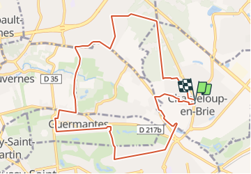
Randonnée Marche de 10,7 km à découvrir à Île-de-France, Seine-et-Marne, Chanteloup-en-Brie. Cette randonnée est proposée par Les 1000 pattes.
Description
Parking Rue de la Gare à Chanteloup en Brie
Trajet Servon-->Chanteloup (27km:25mn)
Du bois de Chigny au golf de Bussy-Guermantes en passant par le parc des Cèdres et le centre aquatique de Marne et Gondoire.
départ parking de la halle de Chanteloup
Localisation
Commentaires
Randonnées à proximité
![Randonnée Marche Coupvray - Boucle > 30 km Coupvray -Meaux - Photo](https://media.geolcdn.com/t/375/260/1a6eabe0-97f0-4d36-8738-577eed6cd854.jpg&format=jpg&maxdim=2)
![Marche Marche](https://static1.geolcdn.com/sitytour/trail-icons/101.png)
Marche
![](/images/other/stat-length.png)
![](https://static1.geolcdn.com/siteimages/upload/files/16400158638029165_repeat_loop_refresh_sync_direction_icon.png)
![Randonnée Marche Dampmart - SM_DAMPMART-EST_8.1Km - Photo](https://media.geolcdn.com/t/375/260/6a085e8e-078f-48e9-8394-a9f3cb910770.jpg&format=jpg&maxdim=2)
![Marche Marche](https://static1.geolcdn.com/sitytour/trail-icons/101.png)
Marche
![](/images/other/stat-length.png)
![](https://static1.geolcdn.com/siteimages/upload/files/16400158638029165_repeat_loop_refresh_sync_direction_icon.png)
![Randonnée Marche Coupvray - SM_COUPVRAY_7.8Km - Photo](https://media.geolcdn.com/t/375/260/75105a38-25f4-4fb7-9ca5-8fbd77a01d44.jpg&format=jpg&maxdim=2)
![Marche Marche](https://static1.geolcdn.com/sitytour/trail-icons/101.png)
Marche
![](/images/other/stat-length.png)
![](https://static1.geolcdn.com/siteimages/upload/files/16400158638029165_repeat_loop_refresh_sync_direction_icon.png)
![Randonnée Marche Coupvray - Boucle Coupvray - Meaux - Photo](https://media.geolcdn.com/t/375/260/99914e9a-87b8-42e9-a845-46cbd1aef9bb.jpg&format=jpg&maxdim=2)
![Marche Marche](https://static1.geolcdn.com/sitytour/trail-icons/101.png)
Marche
![](/images/other/stat-length.png)
![](https://static1.geolcdn.com/siteimages/upload/files/16400158638029165_repeat_loop_refresh_sync_direction_icon.png)
![Randonnée Marche Bussy-Saint-Georges - Boucle Rentilly - Noisiel - Etang de la Brosse - Etang de la Loy - Photo](https://media.geolcdn.com/t/375/260/2ae0fdb4-e8bd-41dd-b6e1-a0c5cc184bfe.jpg&format=jpg&maxdim=2)
![Marche Marche](https://static1.geolcdn.com/sitytour/trail-icons/101.png)
Marche
![](/images/other/stat-length.png)
![](https://static1.geolcdn.com/siteimages/upload/files/16400158638029165_repeat_loop_refresh_sync_direction_icon.png)
![Randonnée Marche Dampmart - ASAM Dampmart La Dhuys - Photo](https://media.geolcdn.com/t/375/260/ext.jpg?maxdim=2&url=https%3A%2F%2Fstatic1.geolcdn.com%2Fsiteimages%2Fupload%2Ffiles%2F1553511878bg_sport_marche.png)
![Marche Marche](https://static1.geolcdn.com/sitytour/trail-icons/101.png)
Marche
![](/images/other/stat-length.png)
![](https://static1.geolcdn.com/siteimages/upload/files/16400158638029165_repeat_loop_refresh_sync_direction_icon.png)
![Randonnée Marche Dampmart - Boucle 23 km Dampmart Annet sur Marne Base de Jabeline - Photo](https://media.geolcdn.com/t/375/260/b5b3d0bd-39cc-46d3-b0d4-bbe25a7dde4e.jpg&format=jpg&maxdim=2)
![Marche Marche](https://static1.geolcdn.com/sitytour/trail-icons/101.png)
Marche
![](/images/other/stat-length.png)
![](https://static1.geolcdn.com/siteimages/upload/files/16400158638029165_repeat_loop_refresh_sync_direction_icon.png)
![Randonnée Marche Dampmart - Boucle autour de Dampmart - Photo](https://media.geolcdn.com/t/375/260/5feb6ded-9010-40ac-8591-20a068c0f9dc.jpg&format=jpg&maxdim=2)
![Marche Marche](https://static1.geolcdn.com/sitytour/trail-icons/101.png)
Marche
![](/images/other/stat-length.png)
![](https://static1.geolcdn.com/siteimages/upload/files/16400158638029165_repeat_loop_refresh_sync_direction_icon.png)
![Randonnée Marche Saint-Thibault-des-Vignes - J 68 Du Parc de Rentilly au Vallon de la Brosse - Photo](https://media.geolcdn.com/t/375/260/ext.jpg?maxdim=2&url=https%3A%2F%2Fstatic1.geolcdn.com%2Fsiteimages%2Fupload%2Ffiles%2F1553511878bg_sport_marche.png)
![Marche Marche](https://static1.geolcdn.com/sitytour/trail-icons/101.png)
Marche
![](/images/other/stat-length.png)
![](https://static1.geolcdn.com/siteimages/upload/files/16400158638029165_repeat_loop_refresh_sync_direction_icon.png)