![](/images/other/stat-length.png)
![Randonnée Marche Meyzieu - Pt de Meyzieu- ouest 22 09 20- 6.5a 36 g 0.3 d 15 - Photo](https://media.geolcdn.com/t/1900/400/ext.pjpeg?maxdim=2&url=https%3A%2F%2Fstatic1.geolcdn.com%2Fsiteimages%2Fupload%2Ffiles%2F1553511878bg_sport_marche.png)
Pt de Meyzieu- ouest 22 09 20- 6.5a 36 g 0.3 d 15
jtraverse
Utilisateur
![Longueur](/images/other/stat-length.png)
![Altitude max](https://static1.geolcdn.com/siteimages/upload/files/1508320355ic_sort_altitude_max_24dp.png)
![Dénivelé positif](https://static1.geolcdn.com/siteimages/upload/files/1508320355ic_sort_den_pos_24dp.png)
![Km-Effort](/images/other/stat-length.png)
![Altitude min](https://static1.geolcdn.com/siteimages/upload/files/1508320355ic_sort_altitude_min_24dp.png)
![Dénivelé négatif](https://static1.geolcdn.com/siteimages/upload/files/1508320355ic_sort_den_neg_24dp.png)
![Boucle](https://static1.geolcdn.com/siteimages/upload/files/16400158638029165_repeat_loop_refresh_sync_direction_icon.png)
![Marche](https://static1.geolcdn.com/sitytour/trail-icons/101.png)
2h10
Difficulté : Très facile
![Scannez ce code QR pour ouvrir la randonnée dans l'application SityTrail](https://capi.geolives.com/qq0zvz2zws4bq2lad0pu/sitytour/trails/2559143/qr.png?size=200)
Application GPS de randonnée GRATUITE
À propos
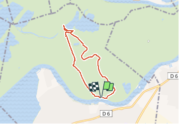
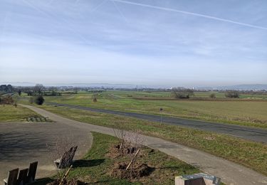
Randonnée Marche de 6,5 km à découvrir à Auvergne-Rhône-Alpes, Métropole de Lyon, Meyzieu. Cette randonnée est proposée par jtraverse.
Description
GL10-GL11-GL12 Pont de Meyzieu-Trajet voiture 14.5km – 17minutes voiture
GPS Pk : 45°47'14.7"N 5°00'35.3"E ou 45.787429, 5.009814
Adresse parking 5 La Garenne 69330 Meyzieu
Direction Rocade Est direction PARIS -Décines-Charpieu, jusqu’à la sortie 6, Puis à gauche (Chemin des Grands Lacs) direction Pont de Meyzieu. Traverser le pont, se garer à gauche ou à droite au bout du pont
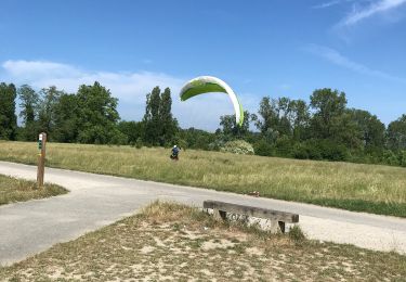
Localisation
Commentaires
Randonnées à proximité
![Randonnée Marche Miribel - A_MIRIBEL 01700 La Droite - Brotteau de Crêt - Photo](https://media.geolcdn.com/t/375/260/ext.jpg?maxdim=2&url=https%3A%2F%2Fstatic1.geolcdn.com%2Fsiteimages%2Fupload%2Ffiles%2F1553511878bg_sport_marche.png)
![Marche Marche](https://static1.geolcdn.com/sitytour/trail-icons/101.png)
Marche
![](/images/other/stat-length.png)
![](https://static1.geolcdn.com/siteimages/upload/files/16400158638029165_repeat_loop_refresh_sync_direction_icon.png)
![Randonnée Marche Miribel - 01_Madone_Miribel_12km190m - Photo](https://media.geolcdn.com/t/375/260/3808a987-c69f-4588-ac24-c5a887686b6d.jpg&format=jpg&maxdim=2)
![Marche Marche](https://static1.geolcdn.com/sitytour/trail-icons/101.png)
Marche
![](/images/other/stat-length.png)
![](https://static1.geolcdn.com/siteimages/upload/files/16400158638029165_repeat_loop_refresh_sync_direction_icon.png)
![Randonnée Marche Miribel - 01-miribel-madone-13km250m - Photo](https://media.geolcdn.com/t/375/260/54e4913b-ef2a-418d-82cf-e68e6db6a21e.jpg&format=jpg&maxdim=2)
![Marche Marche](https://static1.geolcdn.com/sitytour/trail-icons/101.png)
Marche
![](/images/other/stat-length.png)
![](https://static1.geolcdn.com/siteimages/upload/files/16400158638029165_repeat_loop_refresh_sync_direction_icon.png)
![Randonnée Marche Décines-Charpieu - 69-Meribel-grand-tour-du-lac-12km - Photo](https://media.geolcdn.com/t/375/260/2e4f960d-3d44-41ab-8096-3e5ef7efa37e.jpg&format=jpg&maxdim=2)
![Marche Marche](https://static1.geolcdn.com/sitytour/trail-icons/101.png)
Marche
![](/images/other/stat-length.png)
![](https://static1.geolcdn.com/siteimages/upload/files/16400158638029165_repeat_loop_refresh_sync_direction_icon.png)
![Randonnée Marche Miribel - Miribel circuit de la Madone 02 - Photo](https://media.geolcdn.com/t/375/260/ext.jpg?maxdim=2&url=https%3A%2F%2Fstatic1.geolcdn.com%2Fsiteimages%2Fupload%2Ffiles%2F1553511878bg_sport_marche.png)
![Marche Marche](https://static1.geolcdn.com/sitytour/trail-icons/101.png)
Marche
![](/images/other/stat-length.png)
![](https://static1.geolcdn.com/siteimages/upload/files/16400158638029165_repeat_loop_refresh_sync_direction_icon.png)
![Randonnée V.T.T. Décines-Charpieu - Canal de Jonage et canal de Méribel - Photo](https://media.geolcdn.com/t/375/260/ext.jpg?maxdim=2&url=https%3A%2F%2Fstatic1.geolcdn.com%2Fsiteimages%2Fupload%2Ffiles%2F1524743154velo.jpg)
![V.T.T. V.T.T.](https://static1.geolcdn.com/sitytour/trail-icons/202.png)
V.T.T.
![](/images/other/stat-length.png)
![](https://static1.geolcdn.com/siteimages/upload/files/16400158638029165_repeat_loop_refresh_sync_direction_icon.png)
![Randonnée Marche Décines-Charpieu - Espace Biezin DECINES - Photo](https://media.geolcdn.com/t/375/260/9f842f2d-b514-4603-938c-3403b40d5761.jpg&format=jpg&maxdim=2)
![Marche Marche](https://static1.geolcdn.com/sitytour/trail-icons/101.png)
Marche
![](/images/other/stat-length.png)
![](https://static1.geolcdn.com/siteimages/upload/files/16400158638029165_repeat_loop_refresh_sync_direction_icon.png)
![Randonnée V.T.T. Décines-Charpieu - Le tour du parc Miribel - Photo](https://media.geolcdn.com/t/375/260/31c0dcc4-0455-4b1f-aa9a-0bd8c54c9d4d.jpg&format=jpg&maxdim=2)
![V.T.T. V.T.T.](https://static1.geolcdn.com/sitytour/trail-icons/202.png)
V.T.T.
![](/images/other/stat-length.png)
![](https://static1.geolcdn.com/siteimages/upload/files/16400158638029165_repeat_loop_refresh_sync_direction_icon.png)
![Randonnée V.T.T. Décines-Charpieu - 69 -vtt tour de Meribel et Grand Large 36km MAI 2020 - Photo](https://media.geolcdn.com/t/375/260/ae641787-1bda-4fc5-b838-e2f45e93dd37.jpg&format=jpg&maxdim=2)
![V.T.T. V.T.T.](https://static1.geolcdn.com/sitytour/trail-icons/202.png)
V.T.T.
![](/images/other/stat-length.png)
![](https://static1.geolcdn.com/siteimages/upload/files/16400158638029165_repeat_loop_refresh_sync_direction_icon.png)
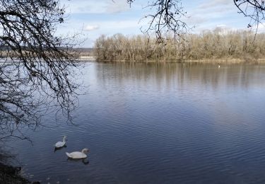
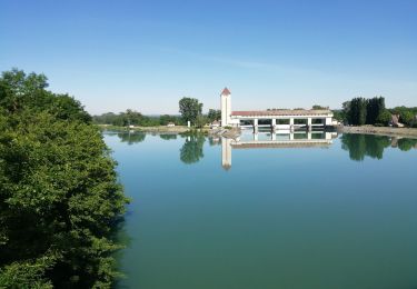
Promenade simple dans la parc de Miribel à deux pas de Lyon.