![](/images/other/stat-length.png)
![Randonnée Marche Freissinières - 2020-09-08 Marche Dormillouse Lacs Palluel Faravel Fangeas - Photo](https://media.geolcdn.com/t/1900/400/21169251-c2dd-4994-a63e-6ea6e20b7955.jpg&format=pjpeg&maxdim=2)
2020-09-08 Marche Dormillouse Lacs Palluel Faravel Fangeas
holtzv
Utilisateur GUIDE
![Longueur](/images/other/stat-length.png)
![Altitude max](https://static1.geolcdn.com/siteimages/upload/files/1508320355ic_sort_altitude_max_24dp.png)
![Dénivelé positif](https://static1.geolcdn.com/siteimages/upload/files/1508320355ic_sort_den_pos_24dp.png)
![Km-Effort](/images/other/stat-length.png)
![Altitude min](https://static1.geolcdn.com/siteimages/upload/files/1508320355ic_sort_altitude_min_24dp.png)
![Dénivelé négatif](https://static1.geolcdn.com/siteimages/upload/files/1508320355ic_sort_den_neg_24dp.png)
![Boucle](https://static1.geolcdn.com/siteimages/upload/files/16400158638029165_repeat_loop_refresh_sync_direction_icon.png)
![Marche](https://static1.geolcdn.com/sitytour/trail-icons/101.png)
5h57
Difficulté : Moyen
![Scannez ce code QR pour ouvrir la randonnée dans l'application SityTrail](https://capi.geolives.com/qq0zvz2zws4bq2lad0pu/sitytour/trails/2543436/qr.png?size=200)
Application GPS de randonnée GRATUITE
À propos
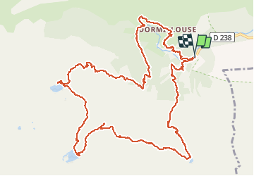
Randonnée Marche de 16,1 km à découvrir à Provence-Alpes-Côte d'Azur, Hautes-Alpes, Freissinières. Cette randonnée est proposée par holtzv.
Description
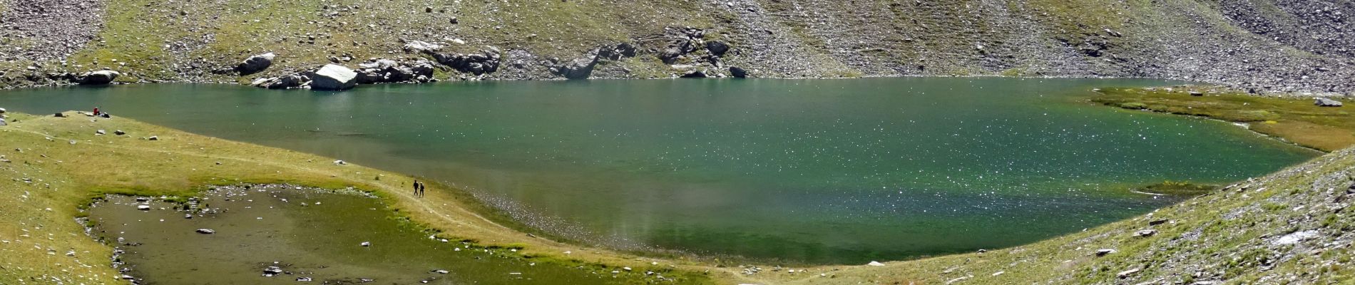
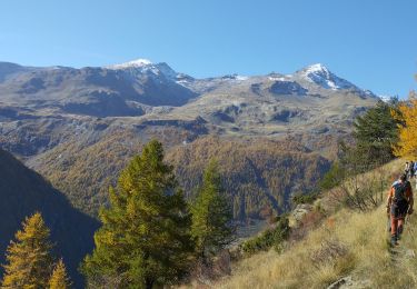
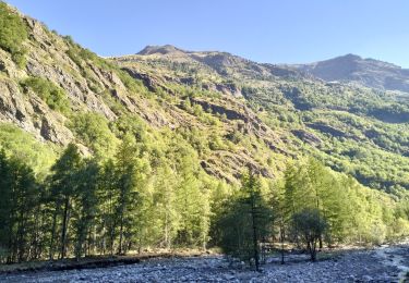
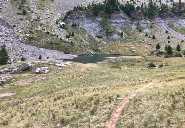
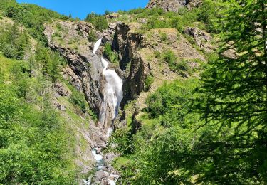
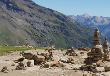
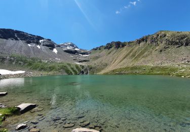
Le début de la marche se fait à travers les petits hameaux de Dormillouse avant de continuer la montée au frais dans la forêt. Arrivée au premier lac de la journée, le lac Palluel (alt 2468m), pour la pause de midi, on enchaine avec le lac de Faravel (alt 2386m) en passant par une mer de Kern. On atteint le troisième Lac de Fangeas (alt 1990m) en passant par le pont de fer. La redescente à travers la forêt offre de beaux points de vue sur le torrent des Oules et la cascade de Dormillouse.
Localisation
Commentaires
Randonnées à proximité
![Randonnée Marche Freissinières - les 3 lacs : Palluel, Faravel et Fangeas + montée grand Pinier - Photo](https://media.geolcdn.com/t/375/260/ext.jpg?maxdim=2&url=https%3A%2F%2Fservices.sitytrail.com%2FGeolivesWS%2FDownloadMedia.ashx%3FTrailID%3D213821%26Media%3Dfix__20130816161219.jpg)
![Marche Marche](https://static1.geolcdn.com/sitytour/trail-icons/101.png)
Marche
![](/images/other/stat-length.png)
![](https://static1.geolcdn.com/siteimages/upload/files/16400158638029165_repeat_loop_refresh_sync_direction_icon.png)
![Randonnée Marche Freissinières - Trois lacs de Dormillouse - Photo](https://media.geolcdn.com/t/375/260/ext.jpg?maxdim=2&url=https%3A%2F%2Fstatic1.geolcdn.com%2Fsiteimages%2Fupload%2Ffiles%2F1553511878bg_sport_marche.png)
![Marche Marche](https://static1.geolcdn.com/sitytour/trail-icons/101.png)
Marche
![](/images/other/stat-length.png)
![](https://static1.geolcdn.com/siteimages/upload/files/16400158638029165_repeat_loop_refresh_sync_direction_icon.png)
![Randonnée Marche Freissinières - les Violins Dormillouse - Photo](https://media.geolcdn.com/t/375/260/46ae824a-5fe7-4309-8011-b209a71cff0c.jpg&format=jpg&maxdim=2)
![Marche Marche](https://static1.geolcdn.com/sitytour/trail-icons/101.png)
Marche
![](/images/other/stat-length.png)
![](https://static1.geolcdn.com/siteimages/upload/files/16400158638029165_repeat_loop_refresh_sync_direction_icon.png)
![Randonnée Marche Freissinières - 05-Dormillouse-lac-Fangeas-pont-fer-11km740m - Photo](https://media.geolcdn.com/t/375/260/c1871a11-c31f-42d4-be0b-750e43234795.jpg&format=jpg&maxdim=2)
![Marche Marche](https://static1.geolcdn.com/sitytour/trail-icons/101.png)
Marche
![](/images/other/stat-length.png)
![](https://static1.geolcdn.com/siteimages/upload/files/16400158638029165_repeat_loop_refresh_sync_direction_icon.png)
![Randonnée Marche Freissinières - Les 3 lacs. Paluel Faravel Frangeas - Photo](https://media.geolcdn.com/t/375/260/41aececb-5518-4303-876a-61d5e49e0b6f.jpg&format=jpg&maxdim=2)
![Marche Marche](https://static1.geolcdn.com/sitytour/trail-icons/101.png)
Marche
![](/images/other/stat-length.png)
![](https://static1.geolcdn.com/siteimages/upload/files/16400158638029165_repeat_loop_refresh_sync_direction_icon.png)
![Randonnée Marche Freissinières - Vallon et lac du Fangeas/20/07/21 - Photo](https://media.geolcdn.com/t/375/260/a7b98803-422a-42bb-95fd-4e0912cde832.jpg&format=jpg&maxdim=2)
![Marche Marche](https://static1.geolcdn.com/sitytour/trail-icons/101.png)
Marche
![](/images/other/stat-length.png)
![](https://static1.geolcdn.com/siteimages/upload/files/16400158638029165_repeat_loop_refresh_sync_direction_icon.png)
![Randonnée Marche Freissinières - parking des cascades, lac de Palluel, lac de Fara vel retour par Dormillouse et le sentier d'hiver - Photo](https://media.geolcdn.com/t/375/260/174f3a1c-2604-4fc5-8be1-97bab62364c4.jpg&format=jpg&maxdim=2)
![Marche Marche](https://static1.geolcdn.com/sitytour/trail-icons/101.png)
Marche
![](/images/other/stat-length.png)
![](https://static1.geolcdn.com/siteimages/upload/files/16400158638029165_repeat_loop_refresh_sync_direction_icon.png)
![Randonnée Marche Freissinières - lacs de Fangeas , Faravel et palluel - Photo](https://media.geolcdn.com/t/375/260/ccff4a91-af95-46da-b421-edaea0f00f03.jpg&format=jpg&maxdim=2)
![Marche Marche](https://static1.geolcdn.com/sitytour/trail-icons/101.png)
Marche
![](/images/other/stat-length.png)
![](https://static1.geolcdn.com/siteimages/upload/files/16400158638029165_repeat_loop_refresh_sync_direction_icon.png)
![Randonnée Marche Freissinières - fangeas - Photo](https://media.geolcdn.com/t/375/260/ext.jpg?maxdim=2&url=https%3A%2F%2Fstatic1.geolcdn.com%2Fsiteimages%2Fupload%2Ffiles%2F1553511878bg_sport_marche.png)
![Marche Marche](https://static1.geolcdn.com/sitytour/trail-icons/101.png)
Marche
![](/images/other/stat-length.png)
![](https://static1.geolcdn.com/siteimages/upload/files/16400158638029165_repeat_loop_refresh_sync_direction_icon.png)