![](/images/other/stat-length.png)
![Randonnée Marche Auflance - Auflance-Puilly 2020 - Photo](https://media.geolcdn.com/t/1900/400/ext.pjpeg?maxdim=2&url=https%3A%2F%2Fstatic1.geolcdn.com%2Fsiteimages%2Fupload%2Ffiles%2F1553511878bg_sport_marche.png)
Auflance-Puilly 2020
fra_depoorter
Utilisateur
![Longueur](/images/other/stat-length.png)
Longueur
9,7 km
![Altitude max](https://static1.geolcdn.com/siteimages/upload/files/1508320355ic_sort_altitude_max_24dp.png)
Altitude max
280 m
![Dénivelé positif](https://static1.geolcdn.com/siteimages/upload/files/1508320355ic_sort_den_pos_24dp.png)
Dénivelé positif
162 m
![Km-Effort](/images/other/stat-length.png)
Km-Effort
11,9 km
![Altitude min](https://static1.geolcdn.com/siteimages/upload/files/1508320355ic_sort_altitude_min_24dp.png)
Altitude min
189 m
![Dénivelé négatif](https://static1.geolcdn.com/siteimages/upload/files/1508320355ic_sort_den_neg_24dp.png)
Dénivelé négatif
162 m
![Boucle](https://static1.geolcdn.com/siteimages/upload/files/16400158638029165_repeat_loop_refresh_sync_direction_icon.png)
Boucle
Oui
Date de création :
2020-09-05 11:47:03.355
Dernière modification :
2020-09-06 16:31:44.95
![Marche](https://static1.geolcdn.com/sitytour/trail-icons/101.png)
2h06
Difficulté : Facile
![Scannez ce code QR pour ouvrir la randonnée dans l'application SityTrail](https://capi.geolives.com/qq0zvz2zws4bq2lad0pu/sitytour/trails/2539144/qr.png?size=200)
Application GPS de randonnée GRATUITE
À propos
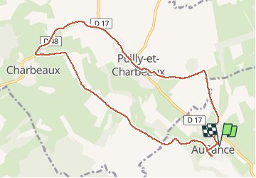
Randonnée Marche de 9,7 km à découvrir à Grand Est, Ardennes, Auflance. Cette randonnée est proposée par fra_depoorter.
Description
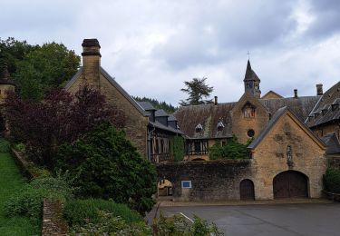
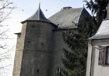
Randonnée à travers la campagne (champs) sans grande difficulté. Les chemins sont en bon état et peu fréquentés. Auflance est un superbe village à découvrir.
Localisation
Pays :
France
Région :
Grand Est
Département/Province :
Ardennes
Commune :
Auflance
Localité :
Unknown
Départ:(Dec)
Départ:(UTM)
665495 ; 5498700 (31U) N.
Commentaires
Randonnées à proximité
![Randonnée Marche Florenville - Orval - Natura 2000, des sites qui valent le détour - Lx24 - Photo](https://media.geolcdn.com/t/375/260/ext.jpg?maxdim=2&url=https%3A%2F%2Fservices.sitytrail.com%2FGeolivesWS%2FDownloadMedia.ashx%3FTrailID%3D570953%26Media%3Dff50a1a1-5aa3-47cc-932f-24cd20f82cdc.JPG)
![Marche Marche](https://static1.geolcdn.com/sitytour/trail-icons/101.png)
Orval - Natura 2000, des sites qui valent le détour - Lx24
Marche
Facile
(2)
Florenville,
Wallonie,
Luxembourg,
Belgique
![](/images/other/stat-length.png)
5,9 km | 7,1 km-effort
1h 33min
![](https://static1.geolcdn.com/siteimages/upload/files/16400158638029165_repeat_loop_refresh_sync_direction_icon.png)
Oui
![Marche Marche](https://static1.geolcdn.com/sitytour/trail-icons/101.png)
Orval circuit didactique
Marche
Moyen
(1)
Florenville,
Wallonie,
Luxembourg,
Belgique
![](/images/other/stat-length.png)
5,1 km | 6,1 km-effort
1h 26min
![](https://static1.geolcdn.com/siteimages/upload/files/16400158638029165_repeat_loop_refresh_sync_direction_icon.png)
Non
![Randonnée A pied Florenville - Le Bois de la Vierge - Photo](https://media.geolcdn.com/t/375/260/ext.jpg?maxdim=2&url=https%3A%2F%2Fpivotmedia.tourismewallonie.be%2FOTH-A0-006F-14SS%2FOTH-A0-006F-14SS.jpg)
![A pied A pied](https://static1.geolcdn.com/sitytour/trail-icons/100.png)
Le Bois de la Vierge
A pied
Facile
Florenville,
Wallonie,
Luxembourg,
Belgique
![](/images/other/stat-length.png)
6,6 km | 8,2 km-effort
1h 52min
![](https://static1.geolcdn.com/siteimages/upload/files/16400158638029165_repeat_loop_refresh_sync_direction_icon.png)
Oui
![Randonnée Marche Florenville - Boucle autour d’Orval - Photo](https://media.geolcdn.com/t/375/260/ext.jpg?maxdim=2&url=https%3A%2F%2Fstatic1.geolcdn.com%2Fsiteimages%2Fupload%2Ffiles%2F1553511878bg_sport_marche.png)
![Marche Marche](https://static1.geolcdn.com/sitytour/trail-icons/101.png)
Boucle autour d’Orval
Marche
(1)
Florenville,
Wallonie,
Luxembourg,
Belgique
![](/images/other/stat-length.png)
3,7 km | 5 km-effort
1h 1min
![](https://static1.geolcdn.com/siteimages/upload/files/16400158638029165_repeat_loop_refresh_sync_direction_icon.png)
Non
![Randonnée Marche Florenville - Orval - Photo](https://media.geolcdn.com/t/375/260/99108acc-6aaa-48e8-bb1a-d7f2c89d8aae.jpg&format=jpg&maxdim=2)
![Marche Marche](https://static1.geolcdn.com/sitytour/trail-icons/101.png)
Orval
Marche
Moyen
Florenville,
Wallonie,
Luxembourg,
Belgique
![](/images/other/stat-length.png)
12,4 km | 15,1 km-effort
2h 44min
![](https://static1.geolcdn.com/siteimages/upload/files/16400158638029165_repeat_loop_refresh_sync_direction_icon.png)
Oui
![Randonnée Marche Florenville - Orval 2020/1 - Photo](https://media.geolcdn.com/t/375/260/ext.jpg?maxdim=2&url=https%3A%2F%2Fstatic1.geolcdn.com%2Fsiteimages%2Fupload%2Ffiles%2F1553511878bg_sport_marche.png)
![Marche Marche](https://static1.geolcdn.com/sitytour/trail-icons/101.png)
Orval 2020/1
Marche
Difficile
(1)
Florenville,
Wallonie,
Luxembourg,
Belgique
![](/images/other/stat-length.png)
10,4 km | 13,6 km-effort
2h 54min
![](https://static1.geolcdn.com/siteimages/upload/files/16400158638029165_repeat_loop_refresh_sync_direction_icon.png)
Oui
![Randonnée Marche Florenville - Orval - 10 Kms - Photo](https://media.geolcdn.com/t/375/260/ext.jpg?maxdim=2&url=https%3A%2F%2Fstatic1.geolcdn.com%2Fsiteimages%2Fupload%2Ffiles%2F1553511878bg_sport_marche.png)
![Marche Marche](https://static1.geolcdn.com/sitytour/trail-icons/101.png)
Orval - 10 Kms
Marche
Moyen
(1)
Florenville,
Wallonie,
Luxembourg,
Belgique
![](/images/other/stat-length.png)
9,5 km | 11,9 km-effort
2h 18min
![](https://static1.geolcdn.com/siteimages/upload/files/16400158638029165_repeat_loop_refresh_sync_direction_icon.png)
Oui
![Randonnée Marche Sapogne-sur-Marche - De Sapogne sur Marche à Margny - Photo](https://media.geolcdn.com/t/375/260/ext.jpg?maxdim=2&url=https%3A%2F%2Fservices.sitytrail.com%2FGeolivesWS%2FDownloadMedia.ashx%3FTrailID%3D118797%26Media%3D13006_6.jpg)
![Marche Marche](https://static1.geolcdn.com/sitytour/trail-icons/101.png)
De Sapogne sur Marche à Margny
Marche
Difficile
Sapogne-sur-Marche,
Grand Est,
Ardennes,
France
![](/images/other/stat-length.png)
15,6 km | 19,9 km-effort
3h 15min
![](https://static1.geolcdn.com/siteimages/upload/files/16400158638029165_repeat_loop_refresh_sync_direction_icon.png)
Oui
![Randonnée Marche Florenville - Réserve naturelle des Prés d’Orval - Photo](https://media.geolcdn.com/t/375/260/6e482ba9-c65c-40fb-9fbe-56ae34c047c6.jpg&format=jpg&maxdim=2)
![Marche Marche](https://static1.geolcdn.com/sitytour/trail-icons/101.png)
Réserve naturelle des Prés d’Orval
Marche
Moyen
Florenville,
Wallonie,
Luxembourg,
Belgique
![](/images/other/stat-length.png)
6 km | 7,3 km-effort
1h 30min
![](https://static1.geolcdn.com/siteimages/upload/files/16400158638029165_repeat_loop_refresh_sync_direction_icon.png)
Oui