![](/images/other/stat-length.png)
![Randonnée Marche Blot-l'Église - Blot_Eglise_Pery - Photo](https://media.geolcdn.com/t/1900/400/d9de8da0-8f81-48e6-a962-7e78784a81e9.jpg&format=pjpeg&maxdim=2)
Blot_Eglise_Pery
jagarnier
Utilisateur GUIDE
![Longueur](/images/other/stat-length.png)
Longueur
9,8 km
![Altitude max](https://static1.geolcdn.com/siteimages/upload/files/1508320355ic_sort_altitude_max_24dp.png)
Altitude max
682 m
![Dénivelé positif](https://static1.geolcdn.com/siteimages/upload/files/1508320355ic_sort_den_pos_24dp.png)
Dénivelé positif
174 m
![Km-Effort](/images/other/stat-length.png)
Km-Effort
12,1 km
![Altitude min](https://static1.geolcdn.com/siteimages/upload/files/1508320355ic_sort_altitude_min_24dp.png)
Altitude min
591 m
![Dénivelé négatif](https://static1.geolcdn.com/siteimages/upload/files/1508320355ic_sort_den_neg_24dp.png)
Dénivelé négatif
174 m
![Boucle](https://static1.geolcdn.com/siteimages/upload/files/16400158638029165_repeat_loop_refresh_sync_direction_icon.png)
Boucle
Oui
Date de création :
2020-09-03 09:49:42.591
Dernière modification :
2023-11-15 10:10:03.333
![Marche](https://static1.geolcdn.com/sitytour/trail-icons/101.png)
3h00
Difficulté : Facile
![Scannez ce code QR pour ouvrir la randonnée dans l'application SityTrail](https://capi.geolives.com/qq0zvz2zws4bq2lad0pu/sitytour/trails/2536329/qr.png?size=200)
Application GPS de randonnée GRATUITE
À propos
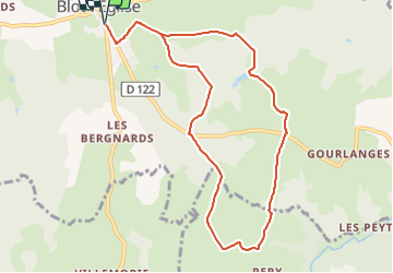
Randonnée Marche de 9,8 km à découvrir à Auvergne-Rhône-Alpes, Puy-de-Dôme, Blot-l'Église. Cette randonnée est proposée par jagarnier.
Description
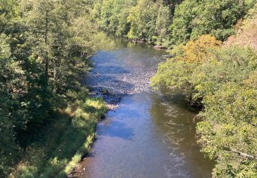
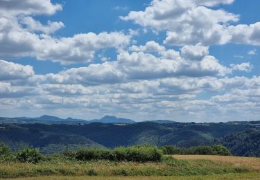
De nombreux passages en terrain dégagé donnent l'occasion d'admirer de beaux panoramas, comme la vallée de la Morge ou la chaine des Puys.
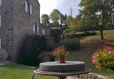
A l'huilerie de Blot, colza, noix, noisettes et autres céréales sont broyées à l'ancienne.
Localisation
Pays :
France
Région :
Auvergne-Rhône-Alpes
Département/Province :
Puy-de-Dôme
Commune :
Blot-l'Église
Localité :
Unknown
Départ:(Dec)
Départ:(UTM)
496564 ; 5098013 (31T) N.
Commentaires
Randonnées à proximité
![Randonnée Marche Charbonnières-les-Vieilles - Charbonnieres_Moulins_Morge_1 - Photo](https://media.geolcdn.com/t/375/260/216388d8-dbb2-4bb2-b898-ee7654baad1a.jpg&format=jpg&maxdim=2)
![Marche Marche](https://static1.geolcdn.com/sitytour/trail-icons/101.png)
Charbonnieres_Moulins_Morge_1
Marche
Moyen
(1)
Charbonnières-les-Vieilles,
Auvergne-Rhône-Alpes,
Puy-de-Dôme,
France
![](/images/other/stat-length.png)
10,7 km | 14,8 km-effort
3h 15min
![](https://static1.geolcdn.com/siteimages/upload/files/16400158638029165_repeat_loop_refresh_sync_direction_icon.png)
Oui
![Randonnée Marche Châteauneuf-les-Bains - La chapelle Saint Valentin - Chateauneuf les Bains - Photo](https://media.geolcdn.com/t/375/260/ext.jpg?maxdim=2&url=https%3A%2F%2Fservices.sitytrail.com%2FGeolivesWS%2FDownloadMedia.ashx%3FTrailID%3D107367%26Media%3D12265_4.jpg)
![Marche Marche](https://static1.geolcdn.com/sitytour/trail-icons/101.png)
La chapelle Saint Valentin - Chateauneuf les Bains
Marche
Moyen
(2)
Châteauneuf-les-Bains,
Auvergne-Rhône-Alpes,
Puy-de-Dôme,
France
![](/images/other/stat-length.png)
14,4 km | 20 km-effort
3h 49min
![](https://static1.geolcdn.com/siteimages/upload/files/16400158638029165_repeat_loop_refresh_sync_direction_icon.png)
Oui
![Randonnée Marche Charbonnières-les-Vieilles - Les moulins de la Morge - Photo](https://media.geolcdn.com/t/375/260/ext.jpg?maxdim=2&url=https%3A%2F%2Fservices.sitytrail.com%2FGeolivesWS%2FDownloadMedia.ashx%3FTrailID%3D104209%26Media%3D7360_2.jpg)
![Marche Marche](https://static1.geolcdn.com/sitytour/trail-icons/101.png)
Les moulins de la Morge
Marche
Moyen
(1)
Charbonnières-les-Vieilles,
Auvergne-Rhône-Alpes,
Puy-de-Dôme,
France
![](/images/other/stat-length.png)
14,5 km | 19,4 km-effort
3h 49min
![](https://static1.geolcdn.com/siteimages/upload/files/16400158638029165_repeat_loop_refresh_sync_direction_icon.png)
Oui
![Randonnée A pied Blot-l'Église - Chapelle Saint-Valentin - Photo](https://media.geolcdn.com/t/375/260/636b7308-827b-484c-af88-d10eb681c6f6.jpeg&format=jpg&maxdim=2)
![A pied A pied](https://static1.geolcdn.com/sitytour/trail-icons/100.png)
Chapelle Saint-Valentin
A pied
Facile
Blot-l'Église,
Auvergne-Rhône-Alpes,
Puy-de-Dôme,
France
![](/images/other/stat-length.png)
13,6 km | 19,6 km-effort
4h 26min
![](https://static1.geolcdn.com/siteimages/upload/files/16400158638029165_repeat_loop_refresh_sync_direction_icon.png)
Oui
![Randonnée A pied Lisseuil - Lisseuil - Photo](https://media.geolcdn.com/t/375/260/5816c14b-dd3a-4f14-83b4-045502c6d651.jpeg&format=jpg&maxdim=2)
![A pied A pied](https://static1.geolcdn.com/sitytour/trail-icons/100.png)
Lisseuil
A pied
Moyen
Lisseuil,
Auvergne-Rhône-Alpes,
Puy-de-Dôme,
France
![](/images/other/stat-length.png)
14,4 km | 20 km-effort
4h 37min
![](https://static1.geolcdn.com/siteimages/upload/files/16400158638029165_repeat_loop_refresh_sync_direction_icon.png)
Oui
![Randonnée V.T.T. Saint-Angel - St-Angel_Sioule_35 - Photo](https://media.geolcdn.com/t/375/260/ext.jpg?maxdim=2&url=https%3A%2F%2Fstatic1.geolcdn.com%2Fsiteimages%2Fupload%2Ffiles%2F1524743154velo.jpg)
![V.T.T. V.T.T.](https://static1.geolcdn.com/sitytour/trail-icons/202.png)
St-Angel_Sioule_35
V.T.T.
Difficile
(1)
Saint-Angel,
Auvergne-Rhône-Alpes,
Puy-de-Dôme,
France
![](/images/other/stat-length.png)
35 km | 49 km-effort
3h 23min
![](https://static1.geolcdn.com/siteimages/upload/files/16400158638029165_repeat_loop_refresh_sync_direction_icon.png)
Oui
![Randonnée Marche Lisseuil - Lisseuil_Chateau_Rocher - Photo](https://media.geolcdn.com/t/375/260/d16a416c-06fd-4b71-8673-2d1f708bade4.jpg&format=jpg&maxdim=2)
![Marche Marche](https://static1.geolcdn.com/sitytour/trail-icons/101.png)
Lisseuil_Chateau_Rocher
Marche
Moyen
(2)
Lisseuil,
Auvergne-Rhône-Alpes,
Puy-de-Dôme,
France
![](/images/other/stat-length.png)
9,2 km | 13,4 km-effort
2h 45min
![](https://static1.geolcdn.com/siteimages/upload/files/16400158638029165_repeat_loop_refresh_sync_direction_icon.png)
Oui
![Randonnée Marche Châteauneuf-les-Bains - Gorges de la sioule - Photo](https://media.geolcdn.com/t/375/260/3e504d16-c296-422e-84ea-74304fd11fa5.jpg&format=jpg&maxdim=2)
![Marche Marche](https://static1.geolcdn.com/sitytour/trail-icons/101.png)
Gorges de la sioule
Marche
Facile
Châteauneuf-les-Bains,
Auvergne-Rhône-Alpes,
Puy-de-Dôme,
France
![](/images/other/stat-length.png)
18,7 km | 27 km-effort
6h 3min
![](https://static1.geolcdn.com/siteimages/upload/files/16400158638029165_repeat_loop_refresh_sync_direction_icon.png)
Oui
![Randonnée V.T.T. Châteauneuf-les-Bains - la chute - Photo](https://media.geolcdn.com/t/375/260/f918e99e-473c-42fc-b4ce-1c1c3aca889f.jpg&format=jpg&maxdim=2)
![V.T.T. V.T.T.](https://static1.geolcdn.com/sitytour/trail-icons/202.png)
la chute
V.T.T.
Très difficile
Châteauneuf-les-Bains,
Auvergne-Rhône-Alpes,
Puy-de-Dôme,
France
![](/images/other/stat-length.png)
23 km | 33 km-effort
4h 30min
![](https://static1.geolcdn.com/siteimages/upload/files/16400158638029165_repeat_loop_refresh_sync_direction_icon.png)
Non