![](/images/other/stat-length.png)
![Randonnée Marche Marigny - Lac de Chalain Marigny 1 sept 2020 CAF - Photo](https://media.geolcdn.com/t/1900/400/6d4cd6ca-3f43-44a7-a9ee-3e22d4a910fa.jpg&format=pjpeg&maxdim=2)
Lac de Chalain Marigny 1 sept 2020 CAF
TRIMAILLE
Utilisateur
![Longueur](/images/other/stat-length.png)
![Altitude max](https://static1.geolcdn.com/siteimages/upload/files/1508320355ic_sort_altitude_max_24dp.png)
![Dénivelé positif](https://static1.geolcdn.com/siteimages/upload/files/1508320355ic_sort_den_pos_24dp.png)
![Km-Effort](/images/other/stat-length.png)
![Altitude min](https://static1.geolcdn.com/siteimages/upload/files/1508320355ic_sort_altitude_min_24dp.png)
![Dénivelé négatif](https://static1.geolcdn.com/siteimages/upload/files/1508320355ic_sort_den_neg_24dp.png)
![Boucle](https://static1.geolcdn.com/siteimages/upload/files/16400158638029165_repeat_loop_refresh_sync_direction_icon.png)
![Marche](https://static1.geolcdn.com/sitytour/trail-icons/101.png)
4h29
Difficulté : Très facile
![Scannez ce code QR pour ouvrir la randonnée dans l'application SityTrail](https://capi.geolives.com/qq0zvz2zws4bq2lad0pu/sitytour/trails/2535237/qr.png?size=200)
Application GPS de randonnée GRATUITE
À propos
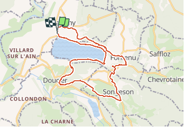
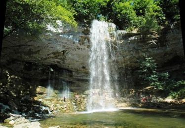
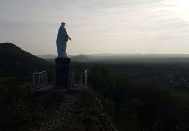
Randonnée Marche de 19,9 km à découvrir à Bourgogne-Franche-Comté, Jura, Marigny. Cette randonnée est proposée par TRIMAILLE.
Description
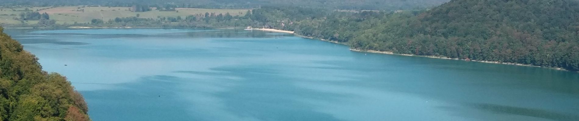
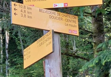
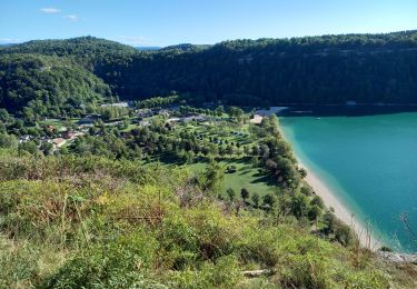
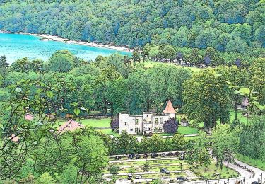
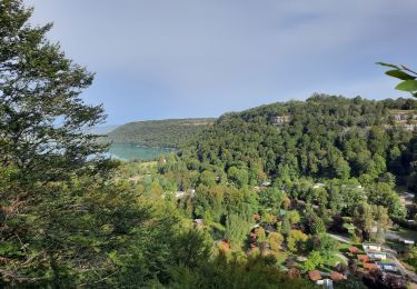
Départ du parking du camping de la Pergola. Agréable rando en bordure du lac et en hauteur. Au Km3,66 le sentier qui descend au lac est fermé en raison de glissements de terrain.
Entre le Km 12, et jusqu'au Km12,5 le sentier n'est pas évident à trouver, d'autant qu'il traverse un lapiaz.
Localisation
Commentaires
Randonnées à proximité
![Randonnée V.T.T. Doucier - La Dame Blanche - Doucier - Photo](https://media.geolcdn.com/t/375/260/ext.jpg?maxdim=2&url=https%3A%2F%2Fservices.sitytrail.com%2FGeolivesWS%2FDownloadMedia.ashx%3FTrailID%3D104084%26Media%3D7109_1.jpg)
![V.T.T. V.T.T.](https://static1.geolcdn.com/sitytour/trail-icons/202.png)
V.T.T.
![](/images/other/stat-length.png)
![](https://static1.geolcdn.com/siteimages/upload/files/16400158638029165_repeat_loop_refresh_sync_direction_icon.png)
![Randonnée Marche Hauteroche - Mirebel avec Taïga - Photo](https://media.geolcdn.com/t/375/260/7abbcb78-a054-422a-acee-9b73230c2c5b.jpg&format=jpg&maxdim=2)
![Marche Marche](https://static1.geolcdn.com/sitytour/trail-icons/101.png)
Marche
![](/images/other/stat-length.png)
![](https://static1.geolcdn.com/siteimages/upload/files/16400158638029165_repeat_loop_refresh_sync_direction_icon.png)
![Randonnée Marche Doucier - Balisage Lac de Chambly - Photo](https://media.geolcdn.com/t/375/260/a66299b1-acba-4c28-b135-ec0a9e2beef8.jpg&format=jpg&maxdim=2)
![Marche Marche](https://static1.geolcdn.com/sitytour/trail-icons/101.png)
Marche
![](/images/other/stat-length.png)
![](https://static1.geolcdn.com/siteimages/upload/files/16400158638029165_repeat_loop_refresh_sync_direction_icon.png)
![Randonnée Marche Fontenu - Tour du lac de Chalain - Photo](https://media.geolcdn.com/t/375/260/1c5595f4-5d36-4f85-b728-7ff9b046c0c9.jpg&format=jpg&maxdim=2)
![Marche Marche](https://static1.geolcdn.com/sitytour/trail-icons/101.png)
Marche
![](/images/other/stat-length.png)
![](https://static1.geolcdn.com/siteimages/upload/files/16400158638029165_repeat_loop_refresh_sync_direction_icon.png)
![Randonnée A pied Marigny - La Queille - Photo](https://media.geolcdn.com/t/375/260/2900c982-6017-4412-a9fc-672092055637.jpeg&format=jpg&maxdim=2)
![A pied A pied](https://static1.geolcdn.com/sitytour/trail-icons/100.png)
A pied
![](/images/other/stat-length.png)
![](https://static1.geolcdn.com/siteimages/upload/files/16400158638029165_repeat_loop_refresh_sync_direction_icon.png)
![Randonnée A pied Fontenu - Tour du Lac - Photo](https://media.geolcdn.com/t/375/260/2900c982-6017-4412-a9fc-672092055637.jpeg&format=jpg&maxdim=2)
![A pied A pied](https://static1.geolcdn.com/sitytour/trail-icons/100.png)
A pied
![](/images/other/stat-length.png)
![](https://static1.geolcdn.com/siteimages/upload/files/16400158638029165_repeat_loop_refresh_sync_direction_icon.png)
![Randonnée Marche Fontenu - GR_559_AC_03_Fontenu_Bonlieu_20210914 - Photo](https://media.geolcdn.com/t/375/260/626a9953-b37f-463e-a917-966facbebecd.jpg&format=jpg&maxdim=2)
![Marche Marche](https://static1.geolcdn.com/sitytour/trail-icons/101.png)
Marche
![](/images/other/stat-length.png)
![](https://static1.geolcdn.com/siteimages/upload/files/16400158638029165_repeat_loop_refresh_sync_direction_icon.png)
![Randonnée Marche Doucier - Le Moulin du Hérisson - Doucier le long du lac Chambly - Photo](https://media.geolcdn.com/t/375/260/03f03b77-53ca-444e-978f-554f51f0468c.jpg&format=jpg&maxdim=2)
![Marche Marche](https://static1.geolcdn.com/sitytour/trail-icons/101.png)
Marche
![](/images/other/stat-length.png)
![](https://static1.geolcdn.com/siteimages/upload/files/16400158638029165_repeat_loop_refresh_sync_direction_icon.png)
![Randonnée Marche Doucier - Doucier tour du village - Photo](https://media.geolcdn.com/t/375/260/7bd9f5d4-11e4-4292-8bd6-74a4e0115bc8.jpg&format=jpg&maxdim=2)
![Marche Marche](https://static1.geolcdn.com/sitytour/trail-icons/101.png)
Marche
![](/images/other/stat-length.png)
![](https://static1.geolcdn.com/siteimages/upload/files/16400158638029165_repeat_loop_refresh_sync_direction_icon.png)