![](/images/other/stat-length.png)
![Randonnée Marche Sassenage - les batteries marche nordique - Photo](https://media.geolcdn.com/t/1900/400/ext.pjpeg?maxdim=2&url=https%3A%2F%2Fstatic1.geolcdn.com%2Fsiteimages%2Fupload%2Ffiles%2F1553511878bg_sport_marche.png)
les batteries marche nordique
cmarit
Utilisateur
![Longueur](/images/other/stat-length.png)
Longueur
9,1 km
![Altitude max](https://static1.geolcdn.com/siteimages/upload/files/1508320355ic_sort_altitude_max_24dp.png)
Altitude max
436 m
![Dénivelé positif](https://static1.geolcdn.com/siteimages/upload/files/1508320355ic_sort_den_pos_24dp.png)
Dénivelé positif
264 m
![Km-Effort](/images/other/stat-length.png)
Km-Effort
12,6 km
![Altitude min](https://static1.geolcdn.com/siteimages/upload/files/1508320355ic_sort_altitude_min_24dp.png)
Altitude min
199 m
![Dénivelé négatif](https://static1.geolcdn.com/siteimages/upload/files/1508320355ic_sort_den_neg_24dp.png)
Dénivelé négatif
264 m
![Boucle](https://static1.geolcdn.com/siteimages/upload/files/16400158638029165_repeat_loop_refresh_sync_direction_icon.png)
Boucle
Oui
Date de création :
2020-09-01 06:30:47.889
Dernière modification :
2020-09-01 11:31:51.379
![Marche](https://static1.geolcdn.com/sitytour/trail-icons/101.png)
2h27
Difficulté : Facile
![Scannez ce code QR pour ouvrir la randonnée dans l'application SityTrail](https://capi.geolives.com/qq0zvz2zws4bq2lad0pu/sitytour/trails/2534338/qr.png?size=200)
Application GPS de randonnée GRATUITE
À propos
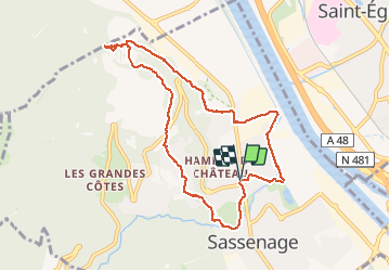
Randonnée Marche de 9,1 km à découvrir à Auvergne-Rhône-Alpes, Isère, Sassenage. Cette randonnée est proposée par cmarit.
Description
Le petit tour en plaine avant de monter mériterait qq retouches pour être plus agréable! Finir avec 9 km est bien, mais trop marcher sur les pistes cyclables et sur le goudron, il y a mieux! Enfin, c’était un échauffement !
Localisation
Pays :
France
Région :
Auvergne-Rhône-Alpes
Département/Province :
Isère
Commune :
Sassenage
Localité :
Unknown
Départ:(Dec)
Départ:(UTM)
708946 ; 5010129 (31T) N.
Commentaires
Randonnées à proximité
![Randonnée Marche Sassenage - La ferme Durand - Photo](https://media.geolcdn.com/t/375/260/94c22489-8db0-4cec-b019-90eab5ac0fa3.jpg&format=jpg&maxdim=2)
![Marche Marche](https://static1.geolcdn.com/sitytour/trail-icons/101.png)
La ferme Durand
Marche
Facile
(2)
Sassenage,
Auvergne-Rhône-Alpes,
Isère,
France
![](/images/other/stat-length.png)
6,2 km | 13,3 km-effort
2h 7min
![](https://static1.geolcdn.com/siteimages/upload/files/16400158638029165_repeat_loop_refresh_sync_direction_icon.png)
Oui
![Randonnée Marche nordique Sassenage - Parc de l'Ovalie - Noyarey - Photo](https://media.geolcdn.com/t/375/260/d032ba44-c97c-4141-ba1d-c30342d72d38.jpg&format=jpg&maxdim=2)
![Marche nordique Marche nordique](https://static1.geolcdn.com/sitytour/trail-icons/102.png)
Parc de l'Ovalie - Noyarey
Marche nordique
Facile
(1)
Sassenage,
Auvergne-Rhône-Alpes,
Isère,
France
![](/images/other/stat-length.png)
11,8 km | 13 km-effort
2h 20min
![](https://static1.geolcdn.com/siteimages/upload/files/16400158638029165_repeat_loop_refresh_sync_direction_icon.png)
Non
![Randonnée Marche Engins - Circuit pas de la Lose, du Tracollet, de l'Ours avec un retour par le passage de la Grande Combe - Photo](https://media.geolcdn.com/t/375/260/e578919b-c81c-4fe4-99cc-8260409f6f79.jpg&format=jpg&maxdim=2)
![Marche Marche](https://static1.geolcdn.com/sitytour/trail-icons/101.png)
Circuit pas de la Lose, du Tracollet, de l'Ours avec un retour par le passage...
Marche
Moyen
(3)
Engins,
Auvergne-Rhône-Alpes,
Isère,
France
![](/images/other/stat-length.png)
10,9 km | 21 km-effort
5h 12min
![](https://static1.geolcdn.com/siteimages/upload/files/16400158638029165_repeat_loop_refresh_sync_direction_icon.png)
Oui
![Randonnée Marche Fontaine - M le 20 cabane de Laura - Photo](https://media.geolcdn.com/t/375/260/40be2dc6-e0ec-4dac-a44e-b55a1a5b0b08.jpg&format=jpg&maxdim=2)
![Marche Marche](https://static1.geolcdn.com/sitytour/trail-icons/101.png)
M le 20 cabane de Laura
Marche
Difficile
(1)
Fontaine,
Auvergne-Rhône-Alpes,
Isère,
France
![](/images/other/stat-length.png)
16,8 km | 30 km-effort
6h 59min
![](https://static1.geolcdn.com/siteimages/upload/files/16400158638029165_repeat_loop_refresh_sync_direction_icon.png)
Oui
![Randonnée Marche Saint-Nizier-du-Moucherotte - GTV - Tour du Vercors à pied - Saint Nizier du Moucherotte - Les Cochettes - Photo](https://media.geolcdn.com/t/375/260/ext.jpg?maxdim=2&url=https%3A%2F%2Fservices.sitytrail.com%2FGeolivesWS%2FDownloadMedia.ashx%3FTrailID%3D112634%26Media%3D11310_2.jpg)
![Marche Marche](https://static1.geolcdn.com/sitytour/trail-icons/101.png)
GTV - Tour du Vercors à pied - Saint Nizier du Moucherotte - Les Cochettes
Marche
Difficile
(1)
Saint-Nizier-du-Moucherotte,
Auvergne-Rhône-Alpes,
Isère,
France
![](/images/other/stat-length.png)
23 km | 42 km-effort
6h 45min
![](https://static1.geolcdn.com/siteimages/upload/files/16400158638029165_repeat_loop_refresh_sync_direction_icon.png)
Non
![Randonnée V.T.T. Grenoble - Grande Traversée des PréAlpes à VTT : Grenoble - Sisteron - Digne les Bains - Photo](https://media.geolcdn.com/t/375/260/ext.jpg?maxdim=2&url=https%3A%2F%2Fservices.sitytrail.com%2FGeolivesWS%2FDownloadMedia.ashx%3FTrailID%3D102152%26Media%3D2542_2.jpg)
![V.T.T. V.T.T.](https://static1.geolcdn.com/sitytour/trail-icons/202.png)
Grande Traversée des PréAlpes à VTT : Grenoble - Sisteron - Digne les Bains
V.T.T.
Très difficile
(2)
Grenoble,
Auvergne-Rhône-Alpes,
Isère,
France
![](/images/other/stat-length.png)
375 km | 539 km-effort
48h 0min
![](https://static1.geolcdn.com/siteimages/upload/files/16400158638029165_repeat_loop_refresh_sync_direction_icon.png)
Non
![Randonnée Marche Engins - 38 engins Molière neige - Photo](https://media.geolcdn.com/t/375/260/34c2e7ec-30ac-4d6d-b1dc-53a50bca429f.jpg&format=jpg&maxdim=2)
![Marche Marche](https://static1.geolcdn.com/sitytour/trail-icons/101.png)
38 engins Molière neige
Marche
Moyen
Engins,
Auvergne-Rhône-Alpes,
Isère,
France
![](/images/other/stat-length.png)
12 km | 22 km-effort
5h 42min
![](https://static1.geolcdn.com/siteimages/upload/files/16400158638029165_repeat_loop_refresh_sync_direction_icon.png)
Oui
![Randonnée Marche Fontaine - Le Moucherotte par le parking sous le tremplin de Saint-Nizier - Photo](https://media.geolcdn.com/t/375/260/c12500b5-9735-4a71-9b4c-b5c3fdd7de5b.jpg&format=jpg&maxdim=2)
![Marche Marche](https://static1.geolcdn.com/sitytour/trail-icons/101.png)
Le Moucherotte par le parking sous le tremplin de Saint-Nizier
Marche
Difficile
Fontaine,
Auvergne-Rhône-Alpes,
Isère,
France
![](/images/other/stat-length.png)
25 km | 48 km-effort
8h 34min
![](https://static1.geolcdn.com/siteimages/upload/files/16400158638029165_repeat_loop_refresh_sync_direction_icon.png)
Oui
![Randonnée Marche Fontaine - Pariset - Ferme de Charvet - Parking sous le tremplin - Sous le Moucherotte - Photo](https://media.geolcdn.com/t/375/260/5bb92c8c-4697-4d2b-afbb-10561dcb69b6.jpg&format=jpg&maxdim=2)
![Marche Marche](https://static1.geolcdn.com/sitytour/trail-icons/101.png)
Pariset - Ferme de Charvet - Parking sous le tremplin - Sous le Moucherotte
Marche
Très difficile
Fontaine,
Auvergne-Rhône-Alpes,
Isère,
France
![](/images/other/stat-length.png)
32 km | 55 km-effort
12h 31min
![](https://static1.geolcdn.com/siteimages/upload/files/16400158638029165_repeat_loop_refresh_sync_direction_icon.png)
Oui