![](/images/other/stat-length.png)
![Randonnée A pied Sigean - Boucle des Cabanes de Port Mahon Sigean - Photo](https://media.geolcdn.com/t/1900/400/ext.pjpeg?maxdim=2&url=https%3A%2F%2Fstatic1.geolcdn.com%2Fsiteimages%2Fupload%2Ffiles%2F1545311037marcheuse_200dpi.jpg)
Boucle des Cabanes de Port Mahon Sigean
SoleilMoussanais
Utilisateur
![Longueur](/images/other/stat-length.png)
Longueur
12,4 km
![Altitude max](https://static1.geolcdn.com/siteimages/upload/files/1508320355ic_sort_altitude_max_24dp.png)
Altitude max
34 m
![Dénivelé positif](https://static1.geolcdn.com/siteimages/upload/files/1508320355ic_sort_den_pos_24dp.png)
Dénivelé positif
113 m
![Km-Effort](/images/other/stat-length.png)
Km-Effort
13,9 km
![Altitude min](https://static1.geolcdn.com/siteimages/upload/files/1508320355ic_sort_altitude_min_24dp.png)
Altitude min
-3 m
![Dénivelé négatif](https://static1.geolcdn.com/siteimages/upload/files/1508320355ic_sort_den_neg_24dp.png)
Dénivelé négatif
113 m
![Boucle](https://static1.geolcdn.com/siteimages/upload/files/16400158638029165_repeat_loop_refresh_sync_direction_icon.png)
Boucle
Oui
Date de création :
2020-08-30 19:51:17.782
Dernière modification :
2020-08-30 20:02:17.696
![A pied](https://static1.geolcdn.com/sitytour/trail-icons/100.png)
3h20
Difficulté : Moyen
![Scannez ce code QR pour ouvrir la randonnée dans l'application SityTrail](https://capi.geolives.com/qq0zvz2zws4bq2lad0pu/sitytour/trails/2532982/qr.png?size=200)
Application GPS de randonnée GRATUITE
À propos
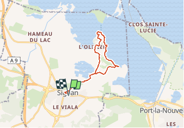
Randonnée A pied de 12,4 km à découvrir à Occitanie, Aude, Sigean. Cette randonnée est proposée par SoleilMoussanais.
Description
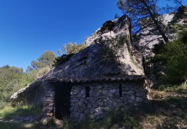
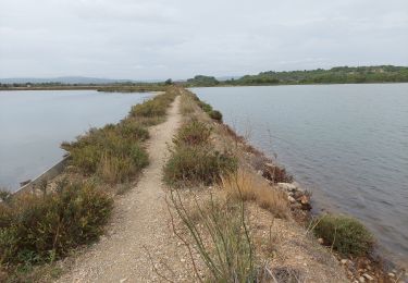
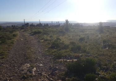
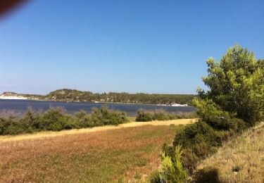
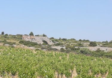
Randonnée en bordure du Grand Salin, visite du hameau des Cabanes de Sigean, table d'orientation avec vue sur l'île de l'Aute et Ste Lucie. Viste du vieux Sigean.
Localisation
Pays :
France
Région :
Occitanie
Département/Province :
Aude
Commune :
Sigean
Localité :
Unknown
Départ:(Dec)
Départ:(UTM)
498495 ; 4763869 (31T) N.
Commentaires
Randonnées à proximité
![Randonnée Marche Roquefort-des-Corbières - Roquefort des Corbières Jean 17.04.22 - Photo](https://media.geolcdn.com/t/375/260/df7e706c-86b4-4f41-b4d6-da42e79bf632.jpg&format=jpg&maxdim=2)
![Marche Marche](https://static1.geolcdn.com/sitytour/trail-icons/101.png)
Roquefort des Corbières Jean 17.04.22
Marche
Moyen
(1)
Roquefort-des-Corbières,
Occitanie,
Aude,
France
![](/images/other/stat-length.png)
15,3 km | 22 km-effort
3h 46min
![](https://static1.geolcdn.com/siteimages/upload/files/16400158638029165_repeat_loop_refresh_sync_direction_icon.png)
Oui
![Randonnée Marche Port-la-Nouvelle - Port la nouvelle - Photo](https://media.geolcdn.com/t/375/260/4650213f-f303-4d9e-b2fa-13ce36bb8422.jpg&format=jpg&maxdim=2)
![Marche Marche](https://static1.geolcdn.com/sitytour/trail-icons/101.png)
Port la nouvelle
Marche
Facile
Port-la-Nouvelle,
Occitanie,
Aude,
France
![](/images/other/stat-length.png)
13,4 km | 14,7 km-effort
3h 29min
![](https://static1.geolcdn.com/siteimages/upload/files/16400158638029165_repeat_loop_refresh_sync_direction_icon.png)
Oui
![Randonnée Marche Sigean - port mabon - Photo](https://media.geolcdn.com/t/375/260/8dffe964-f9eb-480b-bba3-e465a645cce6.jpg&format=jpg&maxdim=2)
![Marche Marche](https://static1.geolcdn.com/sitytour/trail-icons/101.png)
![Randonnée Marche Sigean - Les Salins de Sigean - Photo](https://media.geolcdn.com/t/375/260/0c3906c1-ddca-4889-b150-1015072c6404.jpg&format=jpg&maxdim=2)
![Marche Marche](https://static1.geolcdn.com/sitytour/trail-icons/101.png)
Les Salins de Sigean
Marche
Facile
Sigean,
Occitanie,
Aude,
France
![](/images/other/stat-length.png)
15,6 km | 17,6 km-effort
4h 30min
![](https://static1.geolcdn.com/siteimages/upload/files/16400158638029165_repeat_loop_refresh_sync_direction_icon.png)
Oui
![Randonnée Randonnée à dos d'âne Port-la-Nouvelle - Cathare 1 port la nouvelle Durban Corbieres - Photo](https://media.geolcdn.com/t/375/260/e41ebe21-8688-4101-9289-802a8715a742.jpg&format=jpg&maxdim=2)
![Randonnée à dos d'âne Randonnée à dos d'âne](https://static1.geolcdn.com/sitytour/trail-icons/303.png)
Cathare 1 port la nouvelle Durban Corbieres
Randonnée à dos d'âne
Moyen
Port-la-Nouvelle,
Occitanie,
Aude,
France
![](/images/other/stat-length.png)
20 km | 26 km-effort
4h 21min
![](https://static1.geolcdn.com/siteimages/upload/files/16400158638029165_repeat_loop_refresh_sync_direction_icon.png)
Non
![Randonnée Marche Roquefort-des-Corbières - Roquefort 161106 - Photo](https://media.geolcdn.com/t/375/260/ext.jpg?maxdim=2&url=https%3A%2F%2Fstatic1.geolcdn.com%2Fsiteimages%2Fupload%2Ffiles%2F1553511878bg_sport_marche.png)
![Marche Marche](https://static1.geolcdn.com/sitytour/trail-icons/101.png)
Roquefort 161106
Marche
Très facile
(1)
Roquefort-des-Corbières,
Occitanie,
Aude,
France
![](/images/other/stat-length.png)
20 km | 28 km-effort
7h 5min
![](https://static1.geolcdn.com/siteimages/upload/files/16400158638029165_repeat_loop_refresh_sync_direction_icon.png)
Oui
![Randonnée Marche Port-la-Nouvelle - Sentier Cathare - Photo](https://media.geolcdn.com/t/375/260/ext.jpg?maxdim=2&url=https%3A%2F%2Fstatic1.geolcdn.com%2Fsiteimages%2Fupload%2Ffiles%2F1553511878bg_sport_marche.png)
![Marche Marche](https://static1.geolcdn.com/sitytour/trail-icons/101.png)
Sentier Cathare
Marche
Moyen
(2)
Port-la-Nouvelle,
Occitanie,
Aude,
France
![](/images/other/stat-length.png)
360 km | 572 km-effort
Inconnu
![](https://static1.geolcdn.com/siteimages/upload/files/16400158638029165_repeat_loop_refresh_sync_direction_icon.png)
Non
![Randonnée Marche Sigean - Sigean - Photo](https://media.geolcdn.com/t/375/260/ext.jpg?maxdim=2&url=https%3A%2F%2Fservices.sitytrail.com%2FGeolivesWS%2FDownloadMedia.ashx%3FTrailID%3D141900%26Media%3D20120728165702.jpg)
![Marche Marche](https://static1.geolcdn.com/sitytour/trail-icons/101.png)
![Randonnée Marche Roquefort-des-Corbières - boucle pastorale 2019 - Photo](https://media.geolcdn.com/t/375/260/3b7e021d-d9de-4003-8a52-b64e1c3d6460.jpg&format=jpg&maxdim=2)
![Marche Marche](https://static1.geolcdn.com/sitytour/trail-icons/101.png)
boucle pastorale 2019
Marche
Moyen
(1)
Roquefort-des-Corbières,
Occitanie,
Aude,
France
![](/images/other/stat-length.png)
11,2 km | 15,8 km-effort
4h 26min
![](https://static1.geolcdn.com/siteimages/upload/files/16400158638029165_repeat_loop_refresh_sync_direction_icon.png)
Oui