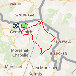
![](/images/other/stat-length.png)
![Randonnée Marche Plombières - Promenade des Trois Bornes (9,5km) - Photo](https://media.geolcdn.com/t/1900/400/ext.pjpeg?maxdim=2&url=https%3A%2F%2Fstatic1.geolcdn.com%2Fsiteimages%2Fupload%2Ffiles%2F1553511878bg_sport_marche.png)
Promenade des Trois Bornes (9,5km)
Maison du Tourisme du pays de Herve
Randonnées de la Maison du Tourisme du Pays de Herve GUIDE+
![Longueur](/images/other/stat-length.png)
![Altitude max](https://static1.geolcdn.com/siteimages/upload/files/1508320355ic_sort_altitude_max_24dp.png)
![Dénivelé positif](https://static1.geolcdn.com/siteimages/upload/files/1508320355ic_sort_den_pos_24dp.png)
![Km-Effort](/images/other/stat-length.png)
![Altitude min](https://static1.geolcdn.com/siteimages/upload/files/1508320355ic_sort_altitude_min_24dp.png)
![Dénivelé négatif](https://static1.geolcdn.com/siteimages/upload/files/1508320355ic_sort_den_neg_24dp.png)
![Boucle](https://static1.geolcdn.com/siteimages/upload/files/16400158638029165_repeat_loop_refresh_sync_direction_icon.png)
![Marche](https://static1.geolcdn.com/sitytour/trail-icons/101.png)
--
Difficulté : Inconnu
![Scannez ce code QR pour ouvrir la randonnée dans l'application SityTrail](https://capi.geolives.com/qq0zvz2zws4bq2lad0pu/sitytour/trails/253129/qr.png?size=200)
Application GPS de randonnée GRATUITE
À propos
Randonnée Marche de 9,6 km à découvrir à Wallonie, Liège, Plombières. Cette randonnée est proposée par Maison du Tourisme du pays de Herve.
Description
Les Trois Frontières est le point de rencontre entre la Belgique, les Pays Bas et l''Allemagne, et, de 1839 à 1919, de l''ancien territoire de "MORESNET-NEUTRE" (aujourd''hui La Calamine). Les trois bornes présentes sur le site ne le sont qu''à titre symbolique et se situent toutes trois en territoire néerlandais. En réalité, on découvrira le vrai point de rencontre des trois pays à la borne 193, près de la tour, marquée des trois lettres B(Belgique) D(Allemagne) et NL (Pays Bas).
Localisation
Commentaires
Randonnées à proximité
![Randonnée Marche La Calamine - Le pays calaminaire - Photo](https://media.geolcdn.com/t/375/260/30655fe2-e81a-47ed-96f4-20092bed94b7.jpg&format=jpg&maxdim=2)
![Marche Marche](https://static1.geolcdn.com/sitytour/trail-icons/101.png)
Marche
![](/images/other/stat-length.png)
![](https://static1.geolcdn.com/siteimages/upload/files/16400158638029165_repeat_loop_refresh_sync_direction_icon.png)
![Randonnée Marche Vaals - Lemiers _788 - Photo](https://media.geolcdn.com/t/375/260/bd8f5c72-b581-4e46-b6f7-9a77fca5b16a.jpg&format=jpg&maxdim=2)
![Marche Marche](https://static1.geolcdn.com/sitytour/trail-icons/101.png)
Marche
![](/images/other/stat-length.png)
![](https://static1.geolcdn.com/siteimages/upload/files/16400158638029165_repeat_loop_refresh_sync_direction_icon.png)
![Randonnée Marche Vaals - Lemiers _235 - Photo](https://media.geolcdn.com/t/375/260/2b2b6b31-a826-484c-a3a8-d4c3abde9549.jpg&format=jpg&maxdim=2)
![Marche Marche](https://static1.geolcdn.com/sitytour/trail-icons/101.png)
Marche
![](/images/other/stat-length.png)
![](https://static1.geolcdn.com/siteimages/upload/files/16400158638029165_repeat_loop_refresh_sync_direction_icon.png)
![Randonnée Marche La Calamine - La Calamine - Photo](https://media.geolcdn.com/t/375/260/606e5792-434a-491a-b5eb-2bfc2ef6f1ed.jpg&format=jpg&maxdim=2)
![Marche Marche](https://static1.geolcdn.com/sitytour/trail-icons/101.png)
Marche
![](/images/other/stat-length.png)
![](https://static1.geolcdn.com/siteimages/upload/files/16400158638029165_repeat_loop_refresh_sync_direction_icon.png)
![Randonnée Marche Aix-la-Chapelle - Aix-la-Chapelle - Photo](https://media.geolcdn.com/t/375/260/19678e47-68ef-4997-bad3-67eb75fafd82.jpg&format=jpg&maxdim=2)
![Marche Marche](https://static1.geolcdn.com/sitytour/trail-icons/101.png)
Marche
![](/images/other/stat-length.png)
![](https://static1.geolcdn.com/siteimages/upload/files/16400158638029165_repeat_loop_refresh_sync_direction_icon.png)
![Randonnée Marche La Calamine - Kelmis - Photo](https://media.geolcdn.com/t/375/260/9eea9d75-ea39-4660-b255-7d2a2255555e.jpg&format=jpg&maxdim=2)
![Marche Marche](https://static1.geolcdn.com/sitytour/trail-icons/101.png)
Marche
![](/images/other/stat-length.png)
![](https://static1.geolcdn.com/siteimages/upload/files/16400158638029165_repeat_loop_refresh_sync_direction_icon.png)
![Randonnée Marche Vaals - Vaals_1431 - Photo](https://media.geolcdn.com/t/375/260/be698cb8-a234-4803-8ecd-dfa4be54f61b.jpg&format=jpg&maxdim=2)
![Marche Marche](https://static1.geolcdn.com/sitytour/trail-icons/101.png)
Marche
![](/images/other/stat-length.png)
![](https://static1.geolcdn.com/siteimages/upload/files/16400158638029165_repeat_loop_refresh_sync_direction_icon.png)
![Randonnée Marche Raeren - Hauset - Photo](https://media.geolcdn.com/t/375/260/4dbde2fb-33e3-4e75-84b3-1404a45e04cc.jpg&format=jpg&maxdim=2)
![Marche Marche](https://static1.geolcdn.com/sitytour/trail-icons/101.png)
![Randonnée Marche La Calamine - 20200730 - Les 3 Bornes 7.3 Km - Photo](https://media.geolcdn.com/t/375/260/ab7b3f98-4235-4a73-ba70-1bedd5c785f3.jpg&format=jpg&maxdim=2)
![Marche Marche](https://static1.geolcdn.com/sitytour/trail-icons/101.png)
Marche
![](/images/other/stat-length.png)
![](https://static1.geolcdn.com/siteimages/upload/files/16400158638029165_repeat_loop_refresh_sync_direction_icon.png)