![](/images/other/stat-length.png)
![Randonnée Marche Sainte-Marie-aux-Mines - Col de Ste Marie aux Mines (27/8/2020) - Photo](https://media.geolcdn.com/t/1900/400/3833d58d-a4ad-4457-8aab-f5dc83ae5397.jpg&format=pjpeg&maxdim=2)
Col de Ste Marie aux Mines (27/8/2020)
Richard68500
Utilisateur
![Longueur](/images/other/stat-length.png)
![Altitude max](https://static1.geolcdn.com/siteimages/upload/files/1508320355ic_sort_altitude_max_24dp.png)
![Dénivelé positif](https://static1.geolcdn.com/siteimages/upload/files/1508320355ic_sort_den_pos_24dp.png)
![Km-Effort](/images/other/stat-length.png)
![Altitude min](https://static1.geolcdn.com/siteimages/upload/files/1508320355ic_sort_altitude_min_24dp.png)
![Dénivelé négatif](https://static1.geolcdn.com/siteimages/upload/files/1508320355ic_sort_den_neg_24dp.png)
![Boucle](https://static1.geolcdn.com/siteimages/upload/files/16400158638029165_repeat_loop_refresh_sync_direction_icon.png)
![Marche](https://static1.geolcdn.com/sitytour/trail-icons/101.png)
5h04
Difficulté : Moyen
![Scannez ce code QR pour ouvrir la randonnée dans l'application SityTrail](https://capi.geolives.com/qq0zvz2zws4bq2lad0pu/sitytour/trails/2530042/qr.png?size=200)
Application GPS de randonnée GRATUITE
À propos
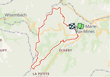
Randonnée Marche de 18,3 km à découvrir à Grand Est, Haut-Rhin, Sainte-Marie-aux-Mines. Cette randonnée est proposée par Richard68500.
Description
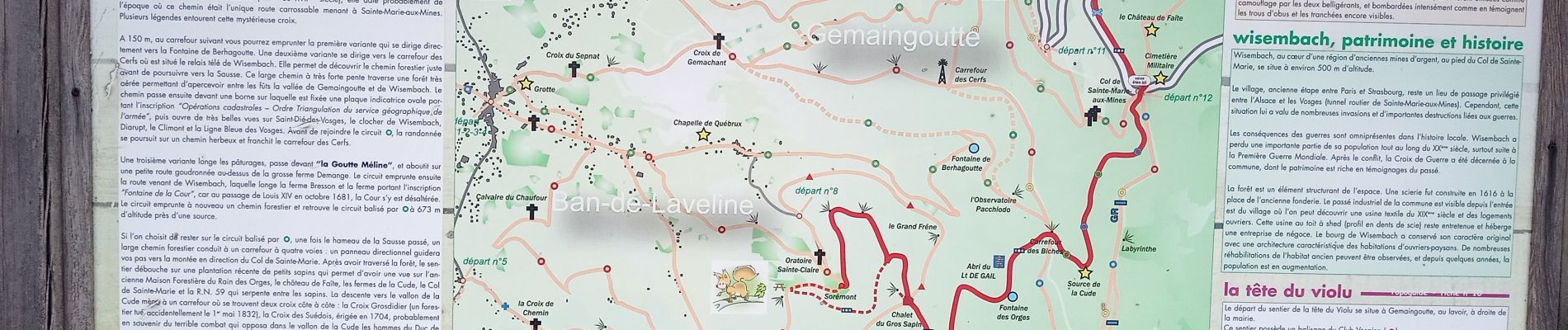
En voiture direction Ste Marie aux Mines pour le départ de
la randonnée.
- Direction refuge Robino
- sur le GR 531 vers le
- Rocher des Chèvres
- Col de ste Marie aux Mines (repas tiré du sac)
Le col de Sainte-Marie est un col du massif des Vosges, situé à 772 mètres.
-Arbre de la Liberté
- puis de la descente pour retrouver la voiture.
Localisation
Commentaires
Randonnées à proximité
![Randonnée Marche Sainte-Marie-aux-Mines - 2020-06-20 Marche Tete du Violu Col de Ste Marie - Photo](https://media.geolcdn.com/t/375/260/d44ae4f7-8944-4d5a-a40f-b5db5e1cd846.jpg&format=jpg&maxdim=2)
![Marche Marche](https://static1.geolcdn.com/sitytour/trail-icons/101.png)
Marche
![](/images/other/stat-length.png)
![](https://static1.geolcdn.com/siteimages/upload/files/16400158638029165_repeat_loop_refresh_sync_direction_icon.png)
![Randonnée Randonnée équestre Aubure - 2019-11-03 WE Aubure Taennchel - Photo](https://media.geolcdn.com/t/375/260/c26e7bc2-614c-4d3d-aa64-9841fd99c8a7.jpg&format=jpg&maxdim=2)
![Randonnée équestre Randonnée équestre](https://static1.geolcdn.com/sitytour/trail-icons/301.png)
Randonnée équestre
![](/images/other/stat-length.png)
![](https://static1.geolcdn.com/siteimages/upload/files/16400158638029165_repeat_loop_refresh_sync_direction_icon.png)
![Randonnée Randonnée équestre Aubure - 2019-11-02 WE Aubure Brezouard - Photo](https://media.geolcdn.com/t/375/260/5d69d4d4-e700-46e3-b109-02de2c2499c8.jpg&format=jpg&maxdim=2)
![Randonnée équestre Randonnée équestre](https://static1.geolcdn.com/sitytour/trail-icons/301.png)
Randonnée équestre
![](/images/other/stat-length.png)
![](https://static1.geolcdn.com/siteimages/upload/files/16400158638029165_repeat_loop_refresh_sync_direction_icon.png)
![Randonnée Marche Sainte-Marie-aux-Mines - la croix de Ribeauvillé - Photo](https://media.geolcdn.com/t/375/260/d5b1ea95-9e8b-4e75-bd59-dd918afbb44b.jpg&format=jpg&maxdim=2)
![Marche Marche](https://static1.geolcdn.com/sitytour/trail-icons/101.png)
Marche
![](/images/other/stat-length.png)
![](https://static1.geolcdn.com/siteimages/upload/files/16400158638029165_repeat_loop_refresh_sync_direction_icon.png)
![Randonnée Randonnée équestre Aubure - Circuit Alsace Cigognes Aubure Plainfaing - Photo](https://media.geolcdn.com/t/375/260/afad8878-23a0-4d83-b9b1-56130ab42de1.jpg&format=jpg&maxdim=2)
![Randonnée équestre Randonnée équestre](https://static1.geolcdn.com/sitytour/trail-icons/301.png)
Randonnée équestre
![](/images/other/stat-length.png)
![](https://static1.geolcdn.com/siteimages/upload/files/16400158638029165_repeat_loop_refresh_sync_direction_icon.png)
![Randonnée Marche Sainte-Marie-aux-Mines - taenichel - Photo](https://media.geolcdn.com/t/375/260/f89cec21-9478-4217-bf8a-15cadae40096.jpg&format=jpg&maxdim=2)
![Marche Marche](https://static1.geolcdn.com/sitytour/trail-icons/101.png)
Marche
![](/images/other/stat-length.png)
![](https://static1.geolcdn.com/siteimages/upload/files/16400158638029165_repeat_loop_refresh_sync_direction_icon.png)
![Randonnée Marche Sainte-Marie-aux-Mines - Col du Haut de Ribeauvillé - Rochers des Géants (Rother n°31) - Photo](https://media.geolcdn.com/t/375/260/cfbc15a6-3f32-42dc-813b-8bce71fe94c9.jpg&format=jpg&maxdim=2)
![Marche Marche](https://static1.geolcdn.com/sitytour/trail-icons/101.png)
Marche
![](/images/other/stat-length.png)
![](https://static1.geolcdn.com/siteimages/upload/files/16400158638029165_repeat_loop_refresh_sync_direction_icon.png)
![Randonnée Marche Sainte-Marie-aux-Mines - rocher des chèvred - Photo](https://media.geolcdn.com/t/375/260/1ee03ea7-dcc4-4aab-8946-92ada103a5f7.jpg&format=jpg&maxdim=2)
![Marche Marche](https://static1.geolcdn.com/sitytour/trail-icons/101.png)
Marche
![](/images/other/stat-length.png)
![](https://static1.geolcdn.com/siteimages/upload/files/16400158638029165_repeat_loop_refresh_sync_direction_icon.png)
![Randonnée Marche Gemaingoutte - col Sainte Marie aux mines - Photo](https://media.geolcdn.com/t/375/260/644b77d8-a894-4e68-a040-8ae35dcbcebd.jpg&format=jpg&maxdim=2)
![Marche Marche](https://static1.geolcdn.com/sitytour/trail-icons/101.png)
Marche
![](/images/other/stat-length.png)
![](https://static1.geolcdn.com/siteimages/upload/files/16400158638029165_repeat_loop_refresh_sync_direction_icon.png)