![](/images/other/stat-length.png)
![Randonnée Marche Eijsden-Margraten - Noorbeek - Wesch - Libeek - Mheer - Photo](https://media.geolcdn.com/t/1900/400/a426e01c-fd87-4702-99a7-349000096829.jpg&format=pjpeg&maxdim=2)
Noorbeek - Wesch - Libeek - Mheer
mumu.larandonneuse
Utilisateur GUIDE
![Longueur](/images/other/stat-length.png)
Longueur
13,6 km
![Altitude max](https://static1.geolcdn.com/siteimages/upload/files/1508320355ic_sort_altitude_max_24dp.png)
Altitude max
182 m
![Dénivelé positif](https://static1.geolcdn.com/siteimages/upload/files/1508320355ic_sort_den_pos_24dp.png)
Dénivelé positif
208 m
![Km-Effort](/images/other/stat-length.png)
Km-Effort
16,3 km
![Altitude min](https://static1.geolcdn.com/siteimages/upload/files/1508320355ic_sort_altitude_min_24dp.png)
Altitude min
105 m
![Dénivelé négatif](https://static1.geolcdn.com/siteimages/upload/files/1508320355ic_sort_den_neg_24dp.png)
Dénivelé négatif
206 m
![Boucle](https://static1.geolcdn.com/siteimages/upload/files/16400158638029165_repeat_loop_refresh_sync_direction_icon.png)
Boucle
Oui
Date de création :
2020-08-24 08:53:53.017
Dernière modification :
2020-08-24 12:56:54.191
![Marche](https://static1.geolcdn.com/sitytour/trail-icons/101.png)
2h58
Difficulté : Facile
![Scannez ce code QR pour ouvrir la randonnée dans l'application SityTrail](https://capi.geolives.com/qq0zvz2zws4bq2lad0pu/sitytour/trails/2526207/qr.png?size=200)
Application GPS de randonnée GRATUITE
À propos
Randonnée Marche de 13,6 km à découvrir à Limbourg, Inconnu, Eijsden-Margraten. Cette randonnée est proposée par mumu.larandonneuse.
Description
Vallée du Noor et le Hoogbos.
D/A : Église de Noorbeek
Descriptif complet sur www.wandelgidszuidlimburg.com n° 720
Localisation
Pays :
Pays-Bas
Région :
Limbourg
Département/Province :
Inconnu
Commune :
Eijsden-Margraten
Localité :
Unknown
Départ:(Dec)
Départ:(UTM)
698122 ; 5627852 (31U) N.
Commentaires
Randonnées à proximité
![Randonnée Marche Eijsden-Margraten - Mheer MH1 - Photo](https://media.geolcdn.com/t/375/260/1dd6d074-f00f-48cf-a4e6-d95117778ebf.jpg&format=jpg&maxdim=2)
![Marche Marche](https://static1.geolcdn.com/sitytour/trail-icons/101.png)
Mheer MH1
Marche
Moyen
(1)
Eijsden-Margraten,
Limbourg,
Inconnu,
Pays-Bas
![](/images/other/stat-length.png)
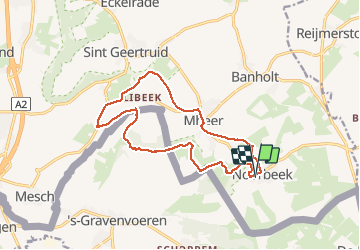
8,8 km | 11 km-effort
2h 29min
![](https://static1.geolcdn.com/siteimages/upload/files/16400158638029165_repeat_loop_refresh_sync_direction_icon.png)
Oui
![Randonnée Marche Eijsden-Margraten - Mheer - Banholt - Hoogbos - Photo](https://media.geolcdn.com/t/375/260/1f70cdf1-9a0b-4d25-acc7-7c75993bbb86.jpg&format=jpg&maxdim=2)
![Marche Marche](https://static1.geolcdn.com/sitytour/trail-icons/101.png)
Mheer - Banholt - Hoogbos
Marche
Moyen
(1)
Eijsden-Margraten,
Limbourg,
Inconnu,
Pays-Bas
![](/images/other/stat-length.png)
12,5 km | 14,5 km-effort
3h 4min
![](https://static1.geolcdn.com/siteimages/upload/files/16400158638029165_repeat_loop_refresh_sync_direction_icon.png)
Oui
![Randonnée Marche Fourons - Amstel Gold Race 2024 🚲 - Photo](https://media.geolcdn.com/t/375/260/bca146f7-0c03-4970-a3ca-ea328283e994.jpg&format=jpg&maxdim=2)
![Marche Marche](https://static1.geolcdn.com/sitytour/trail-icons/101.png)
Amstel Gold Race 2024 🚲
Marche
Moyen
(1)
Fourons,
Flandre,
Limbourg,
Belgique
![](/images/other/stat-length.png)
11,7 km | 14,9 km-effort
3h 23min
![](https://static1.geolcdn.com/siteimages/upload/files/16400158638029165_repeat_loop_refresh_sync_direction_icon.png)
Oui
![Randonnée Marche Fourons - Ulvend - La Planck - Noorbeek - Photo](https://media.geolcdn.com/t/375/260/1b8a3af4-c436-4943-b8e2-3197209c6144.jpg&format=jpg&maxdim=2)
![Marche Marche](https://static1.geolcdn.com/sitytour/trail-icons/101.png)
Ulvend - La Planck - Noorbeek
Marche
Facile
(1)
Fourons,
Flandre,
Limbourg,
Belgique
![](/images/other/stat-length.png)
17 km | 22 km-effort
4h 57min
![](https://static1.geolcdn.com/siteimages/upload/files/16400158638029165_repeat_loop_refresh_sync_direction_icon.png)
Oui
![Randonnée Marche Fourons - Wandelroute-de-voerstreek-mooiste - Photo](https://media.geolcdn.com/t/375/260/3df743f8-88e4-4c10-a47a-c05fdf0072fe.jpg&format=jpg&maxdim=2)
![Marche Marche](https://static1.geolcdn.com/sitytour/trail-icons/101.png)
Wandelroute-de-voerstreek-mooiste
Marche
Moyen
(1)
Fourons,
Flandre,
Limbourg,
Belgique
![](/images/other/stat-length.png)
9,3 km | 12,5 km-effort
2h 49min
![](https://static1.geolcdn.com/siteimages/upload/files/16400158638029165_repeat_loop_refresh_sync_direction_icon.png)
Oui
![Randonnée Marche Fourons - La Commanderie 7 - Photo](https://media.geolcdn.com/t/375/260/e2b67305-0779-4cca-9070-82e3402cc790.jpg&format=jpg&maxdim=2)
![Marche Marche](https://static1.geolcdn.com/sitytour/trail-icons/101.png)
La Commanderie 7
Marche
Facile
(1)
Fourons,
Flandre,
Limbourg,
Belgique
![](/images/other/stat-length.png)
4,5 km | 6,3 km-effort
1h 26min
![](https://static1.geolcdn.com/siteimages/upload/files/16400158638029165_repeat_loop_refresh_sync_direction_icon.png)
Oui
![Randonnée Marche Fourons - Fouron-le-Comte - Photo](https://media.geolcdn.com/t/375/260/e05bdacf-e910-4818-b0aa-de5529cdf1e8.jpg&format=jpg&maxdim=2)
![Marche Marche](https://static1.geolcdn.com/sitytour/trail-icons/101.png)
Fouron-le-Comte
Marche
Facile
(1)
Fourons,
Flandre,
Limbourg,
Belgique
![](/images/other/stat-length.png)
14,5 km | 16,9 km-effort
3h 50min
![](https://static1.geolcdn.com/siteimages/upload/files/16400158638029165_repeat_loop_refresh_sync_direction_icon.png)
Oui
![Randonnée Marche Eijsden-Margraten - Banholt _031 - Photo](https://media.geolcdn.com/t/375/260/136c3226-85ca-4638-b449-da2a119d703c.jpg&format=jpg&maxdim=2)
![Marche Marche](https://static1.geolcdn.com/sitytour/trail-icons/101.png)
Banholt _031
Marche
Facile
(1)
Eijsden-Margraten,
Limbourg,
Inconnu,
Pays-Bas
![](/images/other/stat-length.png)
13,3 km | 15,7 km-effort
3h 34min
![](https://static1.geolcdn.com/siteimages/upload/files/16400158638029165_repeat_loop_refresh_sync_direction_icon.png)
Oui
![Randonnée Marche Gulpen-Wittem - Euverem - Slenaken _1049 - Photo](https://media.geolcdn.com/t/375/260/5452331d-e6b6-4009-a659-a148ef85d520.jpg&format=jpg&maxdim=2)
![Marche Marche](https://static1.geolcdn.com/sitytour/trail-icons/101.png)
Euverem - Slenaken _1049
Marche
Facile
(1)
Gulpen-Wittem,
Limbourg,
Inconnu,
Pays-Bas
![](/images/other/stat-length.png)
14,7 km | 18,7 km-effort
4h 15min
![](https://static1.geolcdn.com/siteimages/upload/files/16400158638029165_repeat_loop_refresh_sync_direction_icon.png)
Oui