![](/images/other/stat-length.png)
![Randonnée Marche Lapoutroie - La tour du Faudé - Les Alisiers - Photo](https://media.geolcdn.com/t/1900/400/e97b008d-01d7-4f56-9433-393ca6b1afc1.jpg&format=pjpeg&maxdim=2)
La tour du Faudé - Les Alisiers
jpksenicz
Utilisateur
![Longueur](/images/other/stat-length.png)
Longueur
5 km
![Altitude max](https://static1.geolcdn.com/siteimages/upload/files/1508320355ic_sort_altitude_max_24dp.png)
Altitude max
764 m
![Dénivelé positif](https://static1.geolcdn.com/siteimages/upload/files/1508320355ic_sort_den_pos_24dp.png)
Dénivelé positif
161 m
![Km-Effort](/images/other/stat-length.png)
Km-Effort
7,2 km
![Altitude min](https://static1.geolcdn.com/siteimages/upload/files/1508320355ic_sort_altitude_min_24dp.png)
Altitude min
600 m
![Dénivelé négatif](https://static1.geolcdn.com/siteimages/upload/files/1508320355ic_sort_den_neg_24dp.png)
Dénivelé négatif
171 m
![Boucle](https://static1.geolcdn.com/siteimages/upload/files/16400158638029165_repeat_loop_refresh_sync_direction_icon.png)
Boucle
Oui
Date de création :
2020-08-20 14:04:48.0
Dernière modification :
2020-08-20 15:25:55.708
![Marche](https://static1.geolcdn.com/sitytour/trail-icons/101.png)
1h16
Difficulté : Facile
![Scannez ce code QR pour ouvrir la randonnée dans l'application SityTrail](https://capi.geolives.com/qq0zvz2zws4bq2lad0pu/sitytour/trails/2521668/qr.png?size=200)
Application GPS de randonnée GRATUITE
À propos
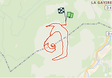
Randonnée Marche de 5 km à découvrir à Grand Est, Haut-Rhin, Lapoutroie. Cette randonnée est proposée par jpksenicz.
Description
Petite balade à partir de l’hôtel-restaurant « Les Alisiers », montée vers le Faudé et sa tour au sommet.
Localisation
Pays :
France
Région :
Grand Est
Département/Province :
Haut-Rhin
Commune :
Lapoutroie
Localité :
Unknown
Départ:(Dec)
Départ:(UTM)
363639 ; 5333882 (32U) N.
Commentaires
Randonnées à proximité
![Randonnée Randonnée équestre Orbey - 2020-06-28 WE Orbey Petit Hohnack Glasborn - Photo](https://media.geolcdn.com/t/375/260/ef012c2d-591e-4a7a-ae45-376661550d14.jpg&format=jpg&maxdim=2)
![Randonnée équestre Randonnée équestre](https://static1.geolcdn.com/sitytour/trail-icons/301.png)
2020-06-28 WE Orbey Petit Hohnack Glasborn
Randonnée équestre
Difficile
(1)
Orbey,
Grand Est,
Haut-Rhin,
France
![](/images/other/stat-length.png)
22 km | 31 km-effort
4h 5min
![](https://static1.geolcdn.com/siteimages/upload/files/16400158638029165_repeat_loop_refresh_sync_direction_icon.png)
Oui
![Randonnée Randonnée équestre Orbey - 2020-06-27 WE Orbey Noir Gazon Vert Forlet - Photo](https://media.geolcdn.com/t/375/260/f691f0a3-eb26-4898-acd3-19530bfd0b6d.jpg&format=jpg&maxdim=2)
![Randonnée équestre Randonnée équestre](https://static1.geolcdn.com/sitytour/trail-icons/301.png)
2020-06-27 WE Orbey Noir Gazon Vert Forlet
Randonnée équestre
Moyen
(1)
Orbey,
Grand Est,
Haut-Rhin,
France
![](/images/other/stat-length.png)
21 km | 30 km-effort
3h 59min
![](https://static1.geolcdn.com/siteimages/upload/files/16400158638029165_repeat_loop_refresh_sync_direction_icon.png)
Oui
![Randonnée Marche Ammerschwihr - Trois Épis le rocher du corbeau - Photo](https://media.geolcdn.com/t/375/260/dbdb5766-f574-4a80-9cd8-371c84f0061c.jpg&format=jpg&maxdim=2)
![Marche Marche](https://static1.geolcdn.com/sitytour/trail-icons/101.png)
Trois Épis le rocher du corbeau
Marche
Facile
(2)
Ammerschwihr,
Grand Est,
Haut-Rhin,
France
![](/images/other/stat-length.png)
4,4 km | 5,7 km-effort
59min
![](https://static1.geolcdn.com/siteimages/upload/files/16400158638029165_repeat_loop_refresh_sync_direction_icon.png)
Oui
![Randonnée V.T.T. Labaroche - Tour de Labaroche - Photo](https://media.geolcdn.com/t/375/260/ext.jpg?maxdim=2&url=https%3A%2F%2Fservices.sitytrail.com%2FGeolivesWS%2FDownloadMedia.ashx%3FTrailID%3D172875%26Media%3D14329_1.jpg)
![V.T.T. V.T.T.](https://static1.geolcdn.com/sitytour/trail-icons/202.png)
Tour de Labaroche
V.T.T.
Moyen
(1)
Labaroche,
Grand Est,
Haut-Rhin,
France
![](/images/other/stat-length.png)
23 km | 31 km-effort
3h 30min
![](https://static1.geolcdn.com/siteimages/upload/files/16400158638029165_repeat_loop_refresh_sync_direction_icon.png)
Oui
![Randonnée Marche Lapoutroie - 2012-06-16 Marche aux Alisiers Orbey - Photo](https://media.geolcdn.com/t/375/260/ext.jpg?maxdim=2&url=https%3A%2F%2Fstatic1.geolcdn.com%2Fsiteimages%2Fupload%2Ffiles%2F1553511878bg_sport_marche.png)
![Marche Marche](https://static1.geolcdn.com/sitytour/trail-icons/101.png)
2012-06-16 Marche aux Alisiers Orbey
Marche
Facile
(2)
Lapoutroie,
Grand Est,
Haut-Rhin,
France
![](/images/other/stat-length.png)
11,1 km | 16,6 km-effort
2h 49min
![](https://static1.geolcdn.com/siteimages/upload/files/16400158638029165_repeat_loop_refresh_sync_direction_icon.png)
Oui
![Randonnée Marche Le Bonhomme - Le Bonhomme - Circuit du village - Photo](https://media.geolcdn.com/t/375/260/ext.jpg?maxdim=2&url=https%3A%2F%2Fstatic1.geolcdn.com%2Fsiteimages%2Fupload%2Ffiles%2F1553511878bg_sport_marche.png)
![Marche Marche](https://static1.geolcdn.com/sitytour/trail-icons/101.png)
Le Bonhomme - Circuit du village
Marche
Facile
(1)
Le Bonhomme,
Grand Est,
Haut-Rhin,
France
![](/images/other/stat-length.png)
3 km | 5,3 km-effort
1h 30min
![](https://static1.geolcdn.com/siteimages/upload/files/16400158638029165_repeat_loop_refresh_sync_direction_icon.png)
Oui
![Randonnée Randonnée équestre Orbey - gite pre au bois gazon du Faing lac blanc lac noir - Photo](https://media.geolcdn.com/t/375/260/ext.jpg?maxdim=2&url=https%3A%2F%2Fstatic1.geolcdn.com%2Fsiteimages%2Fupload%2Ffiles%2F1524743154cheval.jpg)
![Randonnée équestre Randonnée équestre](https://static1.geolcdn.com/sitytour/trail-icons/301.png)
gite pre au bois gazon du Faing lac blanc lac noir
Randonnée équestre
Moyen
(1)
Orbey,
Grand Est,
Haut-Rhin,
France
![](/images/other/stat-length.png)
17,2 km | 25 km-effort
3h 17min
![](https://static1.geolcdn.com/siteimages/upload/files/16400158638029165_repeat_loop_refresh_sync_direction_icon.png)
Oui
![Randonnée Marche Lapoutroie - 2020-07-19 Marche Étang du Devin Col Calvaire Tête des Faux - Photo](https://media.geolcdn.com/t/375/260/615f03a1-e6aa-4706-9550-1df8400dcef8.jpg&format=jpg&maxdim=2)
![Marche Marche](https://static1.geolcdn.com/sitytour/trail-icons/101.png)
2020-07-19 Marche Étang du Devin Col Calvaire Tête des Faux
Marche
Très facile
Lapoutroie,
Grand Est,
Haut-Rhin,
France
![](/images/other/stat-length.png)
14,2 km | 22 km-effort
3h 27min
![](https://static1.geolcdn.com/siteimages/upload/files/16400158638029165_repeat_loop_refresh_sync_direction_icon.png)
Oui
![Randonnée Marche Orbey - PR- Lac B&N-6Km - Photo](https://media.geolcdn.com/t/375/260/ext.jpg?maxdim=2&url=https%3A%2F%2Fstatic1.geolcdn.com%2Fsiteimages%2Fupload%2Ffiles%2F1553511878bg_sport_marche.png)
![Marche Marche](https://static1.geolcdn.com/sitytour/trail-icons/101.png)
PR- Lac B&N-6Km
Marche
Moyen
(1)
Orbey,
Grand Est,
Haut-Rhin,
France
![](/images/other/stat-length.png)
5,5 km | 9,7 km-effort
3h 0min
![](https://static1.geolcdn.com/siteimages/upload/files/16400158638029165_repeat_loop_refresh_sync_direction_icon.png)
Oui