![](/images/other/stat-length.png)
![Randonnée Marche Saint-Aubin-Celloville - Saint-Aubin-Celloville vers Saint-Adrien et retour - Photo](https://media.geolcdn.com/t/1900/400/b87b9f20-fc57-4c0d-b30c-0a8be90badd3.jpg&format=pjpeg&maxdim=2)
Saint-Aubin-Celloville vers Saint-Adrien et retour
MichelRando7656
Utilisateur
![Longueur](/images/other/stat-length.png)
Longueur
11,8 km
![Altitude max](https://static1.geolcdn.com/siteimages/upload/files/1508320355ic_sort_altitude_max_24dp.png)
Altitude max
153 m
![Dénivelé positif](https://static1.geolcdn.com/siteimages/upload/files/1508320355ic_sort_den_pos_24dp.png)
Dénivelé positif
232 m
![Km-Effort](/images/other/stat-length.png)
Km-Effort
14,9 km
![Altitude min](https://static1.geolcdn.com/siteimages/upload/files/1508320355ic_sort_altitude_min_24dp.png)
Altitude min
8 m
![Dénivelé négatif](https://static1.geolcdn.com/siteimages/upload/files/1508320355ic_sort_den_neg_24dp.png)
Dénivelé négatif
234 m
![Boucle](https://static1.geolcdn.com/siteimages/upload/files/16400158638029165_repeat_loop_refresh_sync_direction_icon.png)
Boucle
Oui
Date de création :
2020-08-20 11:16:13.847
Dernière modification :
2020-08-20 15:17:59.711
![Marche](https://static1.geolcdn.com/sitytour/trail-icons/101.png)
4h00
Difficulté : Difficile
![Scannez ce code QR pour ouvrir la randonnée dans l'application SityTrail](https://capi.geolives.com/qq0zvz2zws4bq2lad0pu/sitytour/trails/2521658/qr.png?size=200)
Application GPS de randonnée GRATUITE
À propos
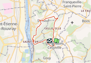
Randonnée Marche de 11,8 km à découvrir à Normandie, Seine-Maritime, Saint-Aubin-Celloville. Cette randonnée est proposée par MichelRando7656.
Description
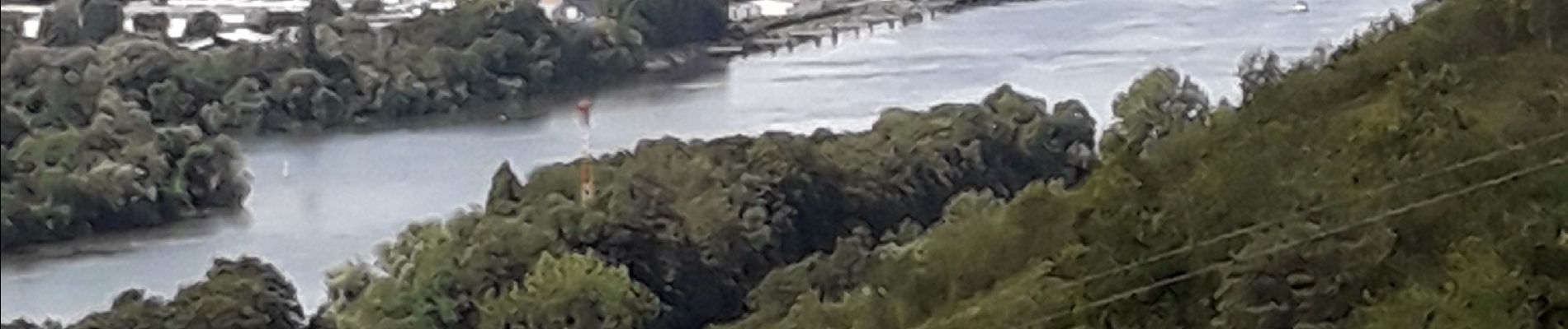
Randonnée campagne et forêts Superbe panorama sur les hauteurs de Saint-Adrien.
2 longues côtes bien raides et une 3 eme pus courte pour terminer le circuit.
A éviter pendant la chasse.
Localisation
Pays :
France
Région :
Normandie
Département/Province :
Seine-Maritime
Commune :
Saint-Aubin-Celloville
Localité :
Unknown
Départ:(Dec)
Départ:(UTM)
366152 ; 5469669 (31U) N.
Commentaires
Randonnées à proximité
![Randonnée Marche Oissel - Oissel 13 km - Variante 5 - Photo](https://media.geolcdn.com/t/375/260/ext.jpg?maxdim=2&url=https%3A%2F%2Fstatic1.geolcdn.com%2Fsiteimages%2Fupload%2Ffiles%2F1553511878bg_sport_marche.png)
![Marche Marche](https://static1.geolcdn.com/sitytour/trail-icons/101.png)
Oissel 13 km - Variante 5
Marche
Très facile
(1)
Oissel,
Normandie,
Seine-Maritime,
France
![](/images/other/stat-length.png)
13,3 km | 15,2 km-effort
2h 35min
![](https://static1.geolcdn.com/siteimages/upload/files/16400158638029165_repeat_loop_refresh_sync_direction_icon.png)
Oui
![Randonnée Marche Oissel - Oissel 15 km - Variante N1 - Photo](https://media.geolcdn.com/t/375/260/ext.jpg?maxdim=2&url=https%3A%2F%2Fstatic1.geolcdn.com%2Fsiteimages%2Fupload%2Ffiles%2F1553511878bg_sport_marche.png)
![Marche Marche](https://static1.geolcdn.com/sitytour/trail-icons/101.png)
Oissel 15 km - Variante N1
Marche
Très facile
(1)
Oissel,
Normandie,
Seine-Maritime,
France
![](/images/other/stat-length.png)
14,9 km | 16,9 km-effort
2h 35min
![](https://static1.geolcdn.com/siteimages/upload/files/16400158638029165_repeat_loop_refresh_sync_direction_icon.png)
Oui
![Randonnée Marche Oissel - Oissel 13 km - Photo](https://media.geolcdn.com/t/375/260/ext.jpg?maxdim=2&url=https%3A%2F%2Fstatic1.geolcdn.com%2Fsiteimages%2Fupload%2Ffiles%2F1553511878bg_sport_marche.png)
![Marche Marche](https://static1.geolcdn.com/sitytour/trail-icons/101.png)
Oissel 13 km
Marche
Très facile
(1)
Oissel,
Normandie,
Seine-Maritime,
France
![](/images/other/stat-length.png)
13,6 km | 15,4 km-effort
2h 35min
![](https://static1.geolcdn.com/siteimages/upload/files/16400158638029165_repeat_loop_refresh_sync_direction_icon.png)
Oui
![Randonnée Marche Ymare - Ymare - Photo](https://media.geolcdn.com/t/375/260/ext.jpg?maxdim=2&url=https%3A%2F%2Fstatic1.geolcdn.com%2Fsiteimages%2Fupload%2Ffiles%2F1553511878bg_sport_marche.png)
![Marche Marche](https://static1.geolcdn.com/sitytour/trail-icons/101.png)
Ymare
Marche
Très facile
(1)
Ymare,
Normandie,
Seine-Maritime,
France
![](/images/other/stat-length.png)
8,9 km | 10,6 km-effort
2h 0min
![](https://static1.geolcdn.com/siteimages/upload/files/16400158638029165_repeat_loop_refresh_sync_direction_icon.png)
Oui
![Randonnée Marche Les Authieux-sur-le-Port-Saint-Ouen - 076-81-les Authieux Igoville 15km-700-813 - Photo](https://media.geolcdn.com/t/375/260/acace470-e678-4207-9fe1-f083d26db0f1.jpg&format=jpg&maxdim=2)
![Marche Marche](https://static1.geolcdn.com/sitytour/trail-icons/101.png)
076-81-les Authieux Igoville 15km-700-813
Marche
Très facile
(1)
Les Authieux-sur-le-Port-Saint-Ouen,
Normandie,
Seine-Maritime,
France
![](/images/other/stat-length.png)
13,9 km | 16,5 km-effort
3h 37min
![](https://static1.geolcdn.com/siteimages/upload/files/16400158638029165_repeat_loop_refresh_sync_direction_icon.png)
Oui
![Marche Marche](https://static1.geolcdn.com/sitytour/trail-icons/101.png)
20240305-Gouy
Marche
Moyen
Les Authieux-sur-le-Port-Saint-Ouen,
Normandie,
Seine-Maritime,
France
![](/images/other/stat-length.png)
10,7 km | 13,1 km-effort
2h 35min
![](https://static1.geolcdn.com/siteimages/upload/files/16400158638029165_repeat_loop_refresh_sync_direction_icon.png)
Oui
![Randonnée Marche Sotteville-sous-le-Val - 20240206-Sotteville sous le Val - Photo](https://media.geolcdn.com/t/375/260/10e7cce0-0471-4b6b-b343-86046b8aac60.jpg&format=jpg&maxdim=2)
![Marche Marche](https://static1.geolcdn.com/sitytour/trail-icons/101.png)
20240206-Sotteville sous le Val
Marche
Moyen
Sotteville-sous-le-Val,
Normandie,
Seine-Maritime,
France
![](/images/other/stat-length.png)
11,4 km | 13,5 km-effort
2h 34min
![](https://static1.geolcdn.com/siteimages/upload/files/16400158638029165_repeat_loop_refresh_sync_direction_icon.png)
Oui
![Randonnée Marche Quévreville-la-Poterie - 20240104-Quevreville la Potterie - Photo](https://media.geolcdn.com/t/375/260/0b8d8346-6b3b-4e80-8d5c-b85557b11606.jpg&format=jpg&maxdim=2)
![Marche Marche](https://static1.geolcdn.com/sitytour/trail-icons/101.png)
20240104-Quevreville la Potterie
Marche
Moyen
Quévreville-la-Poterie,
Normandie,
Seine-Maritime,
France
![](/images/other/stat-length.png)
9,2 km | 11,2 km-effort
2h 43min
![](https://static1.geolcdn.com/siteimages/upload/files/16400158638029165_repeat_loop_refresh_sync_direction_icon.png)
Oui
![Randonnée Marche Quévreville-la-Poterie - 20231219-quevreville noel - Photo](https://media.geolcdn.com/t/375/260/9039af00-539b-4ef5-83fe-9bd657e6d749.jpg&format=jpg&maxdim=2)
![Marche Marche](https://static1.geolcdn.com/sitytour/trail-icons/101.png)
20231219-quevreville noel
Marche
Moyen
Quévreville-la-Poterie,
Normandie,
Seine-Maritime,
France
![](/images/other/stat-length.png)
10,3 km | 12,6 km-effort
2h 55min
![](https://static1.geolcdn.com/siteimages/upload/files/16400158638029165_repeat_loop_refresh_sync_direction_icon.png)
Oui