![](/images/other/stat-length.png)
![Randonnée Marche Montferrier - découverte du château de montsegur et du village par montferroer - Photo](https://media.geolcdn.com/t/1900/400/dbb91943-13a6-421f-97eb-22e28af831f5.jpg&format=pjpeg&maxdim=2)
découverte du château de montsegur et du village par montferroer
fab0202
Utilisateur
![Longueur](/images/other/stat-length.png)
Longueur
12,6 km
![Altitude max](https://static1.geolcdn.com/siteimages/upload/files/1508320355ic_sort_altitude_max_24dp.png)
Altitude max
1189 m
![Dénivelé positif](https://static1.geolcdn.com/siteimages/upload/files/1508320355ic_sort_den_pos_24dp.png)
Dénivelé positif
613 m
![Km-Effort](/images/other/stat-length.png)
Km-Effort
21 km
![Altitude min](https://static1.geolcdn.com/siteimages/upload/files/1508320355ic_sort_altitude_min_24dp.png)
Altitude min
729 m
![Dénivelé négatif](https://static1.geolcdn.com/siteimages/upload/files/1508320355ic_sort_den_neg_24dp.png)
Dénivelé négatif
611 m
![Boucle](https://static1.geolcdn.com/siteimages/upload/files/16400158638029165_repeat_loop_refresh_sync_direction_icon.png)
Boucle
Oui
Date de création :
2020-08-19 07:42:04.903
Dernière modification :
2020-08-19 15:14:02.427
![Marche](https://static1.geolcdn.com/sitytour/trail-icons/101.png)
3h42
Difficulté : Moyen
![Scannez ce code QR pour ouvrir la randonnée dans l'application SityTrail](https://capi.geolives.com/qq0zvz2zws4bq2lad0pu/sitytour/trails/2520404/qr.png?size=200)
Application GPS de randonnée GRATUITE
À propos
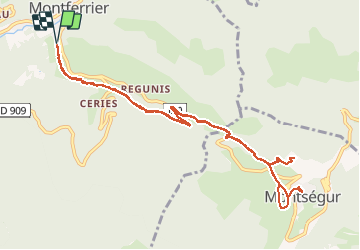
Randonnée Marche de 12,6 km à découvrir à Occitanie, Ariège, Montferrier. Cette randonnée est proposée par fab0202.
Description
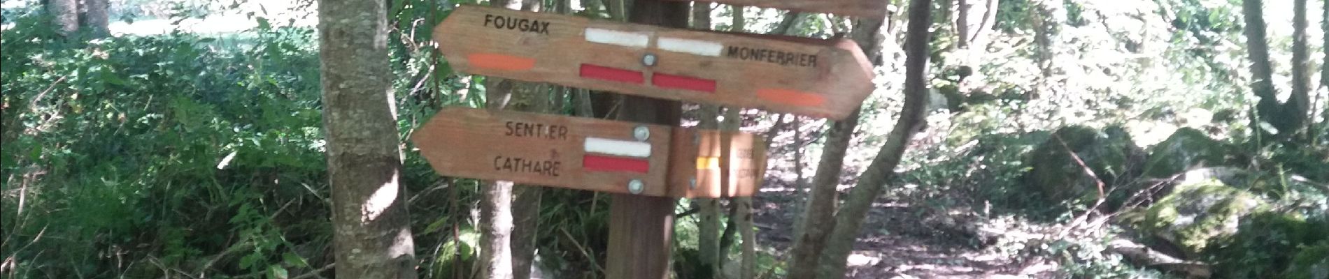
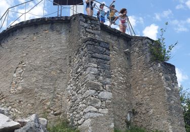
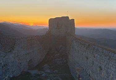
belle rando entre forêt et chateau de montsegur à visiter ainsi que son musée au village (le ticket permet de voir les 2). rando avec belle montée au chateau mais superbe vue
Localisation
Pays :
France
Région :
Occitanie
Département/Province :
Ariège
Commune :
Montferrier
Localité :
Unknown
Départ:(Dec)
Départ:(UTM)
401333 ; 4749344 (31T) N.
Commentaires
Randonnées à proximité
![Randonnée Marche Montferrier - Pic de Saint-Barthélémy - Pla de la Galine - Photo](https://media.geolcdn.com/t/375/260/ext.jpg?maxdim=2&url=https%3A%2F%2Fservices.sitytrail.com%2FGeolivesWS%2FDownloadMedia.ashx%3FTrailID%3D107183%26Media%3D12034_5.jpg)
![Marche Marche](https://static1.geolcdn.com/sitytour/trail-icons/101.png)
Pic de Saint-Barthélémy - Pla de la Galine
Marche
Difficile
(1)
Montferrier,
Occitanie,
Ariège,
France
![](/images/other/stat-length.png)
15,3 km | 31 km-effort
7h 0min
![](https://static1.geolcdn.com/siteimages/upload/files/16400158638029165_repeat_loop_refresh_sync_direction_icon.png)
Oui
![Marche Marche](https://static1.geolcdn.com/sitytour/trail-icons/101.png)
Sentier cathare - Château de Montsegur
Marche
Moyen
Montferrier,
Occitanie,
Ariège,
France
![](/images/other/stat-length.png)
12,6 km | 21 km-effort
4h 48min
![](https://static1.geolcdn.com/siteimages/upload/files/16400158638029165_repeat_loop_refresh_sync_direction_icon.png)
Oui
![Randonnée Vélo électrique Lavelanet - Lavelanet Ste Colombe lac Montbel retour Laroque - Photo](https://media.geolcdn.com/t/375/260/4c93721d-d109-4910-92f4-e8bb9c7e7c78.jpg&format=jpg&maxdim=2)
![Vélo électrique Vélo électrique](https://static1.geolcdn.com/sitytour/trail-icons/205.png)
Lavelanet Ste Colombe lac Montbel retour Laroque
Vélo électrique
Moyen
Lavelanet,
Occitanie,
Ariège,
France
![](/images/other/stat-length.png)
40 km | 44 km-effort
4h 30min
![](https://static1.geolcdn.com/siteimages/upload/files/16400158638029165_repeat_loop_refresh_sync_direction_icon.png)
Oui
![Randonnée Marche Roquefixade - roquefixade - Photo](https://media.geolcdn.com/t/375/260/a4ee5e64-4a22-4a44-afa9-4440a817a12f.jpg&format=jpg&maxdim=2)
![Marche Marche](https://static1.geolcdn.com/sitytour/trail-icons/101.png)
roquefixade
Marche
Facile
Roquefixade,
Occitanie,
Ariège,
France
![](/images/other/stat-length.png)
7,4 km | 10,8 km-effort
4h 0min
![](https://static1.geolcdn.com/siteimages/upload/files/16400158638029165_repeat_loop_refresh_sync_direction_icon.png)
Oui
![Randonnée Marche Lavelanet - Camping Village des Bons-Hommes pour balade-grillade - Photo](https://media.geolcdn.com/t/375/260/e5db2f0d-f510-4eba-beea-b49938a14807.jpg&format=jpg&maxdim=2)
![Marche Marche](https://static1.geolcdn.com/sitytour/trail-icons/101.png)
Camping Village des Bons-Hommes pour balade-grillade
Marche
Très facile
Lavelanet,
Occitanie,
Ariège,
France
![](/images/other/stat-length.png)
4,8 km | 6,5 km-effort
2h 14min
![](https://static1.geolcdn.com/siteimages/upload/files/16400158638029165_repeat_loop_refresh_sync_direction_icon.png)
Oui
![Randonnée Marche Montségur - 03 et 04 - MONTSEGUR COMUS SORGEAT - Chemin des Bons-Hommes GR107 - Photo](https://media.geolcdn.com/t/375/260/695e8c03-f8ca-4a73-a2fc-4cbbe8211d15.jpg&format=jpg&maxdim=2)
![Marche Marche](https://static1.geolcdn.com/sitytour/trail-icons/101.png)
03 et 04 - MONTSEGUR COMUS SORGEAT - Chemin des Bons-Hommes GR107
Marche
Difficile
Montségur,
Occitanie,
Ariège,
France
![](/images/other/stat-length.png)
35 km | 56 km-effort
11h 22min
![](https://static1.geolcdn.com/siteimages/upload/files/16400158638029165_repeat_loop_refresh_sync_direction_icon.png)
Non
![Randonnée Marche Montségur - la Frau - Photo](https://media.geolcdn.com/t/375/260/ext.jpg?maxdim=2&url=https%3A%2F%2Fservices.sitytrail.com%2FGeolivesWS%2FDownloadMedia.ashx%3FTrailID%3D1026292%26Media%3Dfix__20180821154103.jpg)
![Marche Marche](https://static1.geolcdn.com/sitytour/trail-icons/101.png)
![Randonnée Marche Lavelanet - BOUCLE Ste Rufine, Raissac, Péreille d'en Bas et Haut, retour Cambière Bensa - Photo](https://media.geolcdn.com/t/375/260/ext.jpg?maxdim=2&url=https%3A%2F%2Fservices.sitytrail.com%2FGeolivesWS%2FDownloadMedia.ashx%3FTrailID%3D816622%26Media%3Dfix__20170824122820.jpg)
![Marche Marche](https://static1.geolcdn.com/sitytour/trail-icons/101.png)
BOUCLE Ste Rufine, Raissac, Péreille d'en Bas et Haut, retour Cambière Bensa
Marche
Facile
Lavelanet,
Occitanie,
Ariège,
France
![](/images/other/stat-length.png)
13,3 km | 21 km-effort
4h 34min
![](https://static1.geolcdn.com/siteimages/upload/files/16400158638029165_repeat_loop_refresh_sync_direction_icon.png)
Oui
![Randonnée Raquettes à neige Montferrier - Mont d'Olmes - le Planas - Photo](https://media.geolcdn.com/t/375/260/ext.jpg?maxdim=2&url=https%3A%2F%2Fservices.sitytrail.com%2FGeolivesWS%2FDownloadMedia.ashx%3FTrailID%3D696670%26Media%3Dfix__20170211144313.jpg)
![Raquettes à neige Raquettes à neige](https://static1.geolcdn.com/sitytour/trail-icons/504.png)
Mont d'Olmes - le Planas
Raquettes à neige
Facile
Montferrier,
Occitanie,
Ariège,
France
![](/images/other/stat-length.png)
7,2 km | 13,4 km-effort
4h 17min
![](https://static1.geolcdn.com/siteimages/upload/files/16400158638029165_repeat_loop_refresh_sync_direction_icon.png)
Oui