![](/images/other/stat-length.png)
![Randonnée Marche Lescun - Belvédère de Lescun - Photo](https://media.geolcdn.com/t/1900/400/414ecd07-6ae3-47cd-829e-1074abceda8e.jpg&format=pjpeg&maxdim=2)
Belvédère de Lescun
alfreson
Utilisateur
![Longueur](/images/other/stat-length.png)
Longueur
4,4 km
![Altitude max](https://static1.geolcdn.com/siteimages/upload/files/1508320355ic_sort_altitude_max_24dp.png)
Altitude max
1223 m
![Dénivelé positif](https://static1.geolcdn.com/siteimages/upload/files/1508320355ic_sort_den_pos_24dp.png)
Dénivelé positif
327 m
![Km-Effort](/images/other/stat-length.png)
Km-Effort
8,8 km
![Altitude min](https://static1.geolcdn.com/siteimages/upload/files/1508320355ic_sort_altitude_min_24dp.png)
Altitude min
893 m
![Dénivelé négatif](https://static1.geolcdn.com/siteimages/upload/files/1508320355ic_sort_den_neg_24dp.png)
Dénivelé négatif
336 m
![Boucle](https://static1.geolcdn.com/siteimages/upload/files/16400158638029165_repeat_loop_refresh_sync_direction_icon.png)
Boucle
Oui
Date de création :
2020-08-18 08:17:04.0
Dernière modification :
2020-08-18 10:20:07.429
![Marche](https://static1.geolcdn.com/sitytour/trail-icons/101.png)
1h48
Difficulté : Moyen
![Scannez ce code QR pour ouvrir la randonnée dans l'application SityTrail](https://capi.geolives.com/qq0zvz2zws4bq2lad0pu/sitytour/trails/2518682/qr.png?size=200)
Application GPS de randonnée GRATUITE
À propos
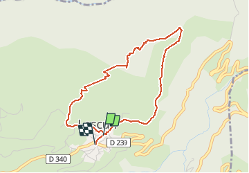
Randonnée Marche de 4,4 km à découvrir à Nouvelle-Aquitaine, Pyrénées-Atlantiques, Lescun. Cette randonnée est proposée par alfreson.
Description
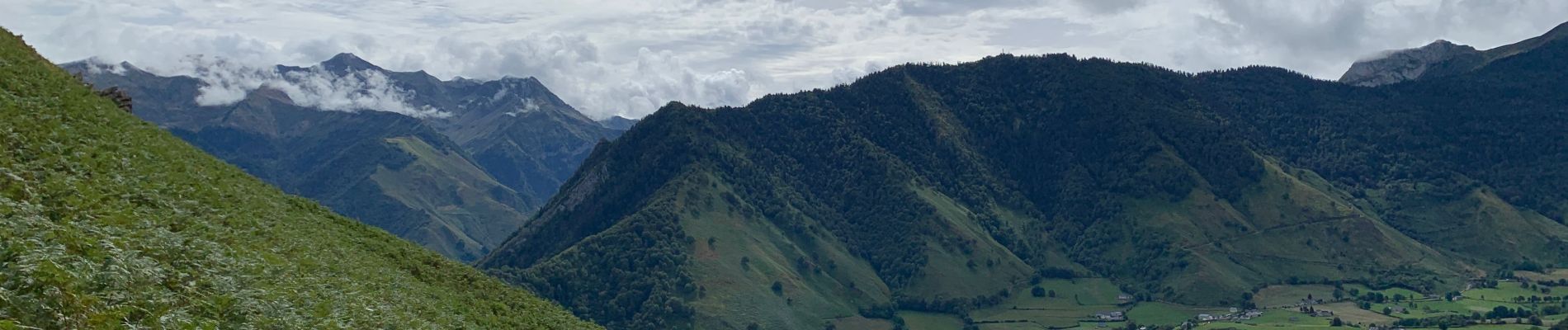
Superbe promenade avec des paysages variés à la montée, vue sur tout le cirque de Lescun, et descente au milieu des fougères 😀 à faire dans ce sens là!
Localisation
Pays :
France
Région :
Nouvelle-Aquitaine
Département/Province :
Pyrénées-Atlantiques
Commune :
Lescun
Localité :
Unknown
Départ:(Dec)
Départ:(UTM)
693047 ; 4756279 (30T) N.
Commentaires
Randonnées à proximité
![Randonnée Marche Accous - ACCOUS Chapelle San Christau](https://media.geolcdn.com/t/375/260/40c2b7e8-ffbe-4c46-b83e-62c3011b6688.jpg&format=jpg&maxdim=2)
![Marche Marche](https://static1.geolcdn.com/sitytour/trail-icons/101.png)
ACCOUS Chapelle San Christau "2805437"
Marche
Facile
(1)
Accous,
Nouvelle-Aquitaine,
Pyrénées-Atlantiques,
France
![](/images/other/stat-length.png)
8,8 km | 14,3 km-effort
2h 44min
![](https://static1.geolcdn.com/siteimages/upload/files/16400158638029165_repeat_loop_refresh_sync_direction_icon.png)
Oui
![Randonnée Marche Lescun - Le plateau de Sanchèse - Lescun - Photo](https://media.geolcdn.com/t/375/260/ext.jpg?maxdim=2&url=https%3A%2F%2Fservices.sitytrail.com%2FGeolivesWS%2FDownloadMedia.ashx%3FTrailID%3D111284%26Media%3D6928_1.jpg)
![Marche Marche](https://static1.geolcdn.com/sitytour/trail-icons/101.png)
Le plateau de Sanchèse - Lescun
Marche
Facile
(2)
Lescun,
Nouvelle-Aquitaine,
Pyrénées-Atlantiques,
France
![](/images/other/stat-length.png)
5,4 km | 7,4 km-effort
2h 0min
![](https://static1.geolcdn.com/siteimages/upload/files/16400158638029165_repeat_loop_refresh_sync_direction_icon.png)
Oui
![Randonnée Marche Lescun - Lac de Lhurs - Photo](https://media.geolcdn.com/t/375/260/ext.jpg?maxdim=2&url=https%3A%2F%2Fservices.sitytrail.com%2FGeolivesWS%2FDownloadMedia.ashx%3FTrailID%3D106243%26Media%3D10574_1.jpg)
![Marche Marche](https://static1.geolcdn.com/sitytour/trail-icons/101.png)
Lac de Lhurs
Marche
Moyen
(2)
Lescun,
Nouvelle-Aquitaine,
Pyrénées-Atlantiques,
France
![](/images/other/stat-length.png)
9,5 km | 19,2 km-effort
4h 0min
![](https://static1.geolcdn.com/siteimages/upload/files/16400158638029165_repeat_loop_refresh_sync_direction_icon.png)
Oui
![Randonnée A pied Accous - Sommet du Poey asp122 - Photo](https://media.geolcdn.com/t/375/260/2d07cf2c-8954-4ab2-916e-821bbcb77891.jpeg&format=jpg&maxdim=2)
![A pied A pied](https://static1.geolcdn.com/sitytour/trail-icons/100.png)
Sommet du Poey asp122
A pied
Facile
Accous,
Nouvelle-Aquitaine,
Pyrénées-Atlantiques,
France
![](/images/other/stat-length.png)
3,5 km | 5,7 km-effort
1h 17min
![](https://static1.geolcdn.com/siteimages/upload/files/16400158638029165_repeat_loop_refresh_sync_direction_icon.png)
Oui
![Randonnée A pied Cette-Eygun - Granges de Cette asp56 - Photo](https://media.geolcdn.com/t/375/260/45ec37bb-ebfa-4fac-a648-b2e50bb11731.jpeg&format=jpg&maxdim=2)
![A pied A pied](https://static1.geolcdn.com/sitytour/trail-icons/100.png)
Granges de Cette asp56
A pied
Facile
Cette-Eygun,
Nouvelle-Aquitaine,
Pyrénées-Atlantiques,
France
![](/images/other/stat-length.png)
5,4 km | 10,2 km-effort
2h 18min
![](https://static1.geolcdn.com/siteimages/upload/files/16400158638029165_repeat_loop_refresh_sync_direction_icon.png)
Oui
![Randonnée A pied Cette-Eygun - Cabane de Lhèze asp116 - Photo](https://media.geolcdn.com/t/375/260/45ec37bb-ebfa-4fac-a648-b2e50bb11731.jpeg&format=jpg&maxdim=2)
![A pied A pied](https://static1.geolcdn.com/sitytour/trail-icons/100.png)
Cabane de Lhèze asp116
A pied
Facile
Cette-Eygun,
Nouvelle-Aquitaine,
Pyrénées-Atlantiques,
France
![](/images/other/stat-length.png)
3,6 km | 9,7 km-effort
2h 11min
![](https://static1.geolcdn.com/siteimages/upload/files/16400158638029165_repeat_loop_refresh_sync_direction_icon.png)
Non
![Randonnée A pied Cette-Eygun - Cabanes de Narbèze asp117 - Photo](https://media.geolcdn.com/t/375/260/45ec37bb-ebfa-4fac-a648-b2e50bb11731.jpeg&format=jpg&maxdim=2)
![A pied A pied](https://static1.geolcdn.com/sitytour/trail-icons/100.png)
Cabanes de Narbèze asp117
A pied
Facile
Cette-Eygun,
Nouvelle-Aquitaine,
Pyrénées-Atlantiques,
France
![](/images/other/stat-length.png)
6,5 km | 16,6 km-effort
3h 45min
![](https://static1.geolcdn.com/siteimages/upload/files/16400158638029165_repeat_loop_refresh_sync_direction_icon.png)
Non
![Randonnée A pied Cette-Eygun - Tour de Lasies asp115 - Photo](https://media.geolcdn.com/t/375/260/c7bf7b32-3f7c-4bff-b706-8b021e3df474.jpeg&format=jpg&maxdim=2)
![A pied A pied](https://static1.geolcdn.com/sitytour/trail-icons/100.png)
Tour de Lasies asp115
A pied
Facile
Cette-Eygun,
Nouvelle-Aquitaine,
Pyrénées-Atlantiques,
France
![](/images/other/stat-length.png)
4,3 km | 8,7 km-effort
1h 59min
![](https://static1.geolcdn.com/siteimages/upload/files/16400158638029165_repeat_loop_refresh_sync_direction_icon.png)
Non
![Randonnée A pied Borce - Sentier de Borce à Belonce PNP - Photo](https://media.geolcdn.com/t/375/260/c9dd0836-6811-4332-bdc7-4bfac8c4af11.jpeg&format=jpg&maxdim=2)
![A pied A pied](https://static1.geolcdn.com/sitytour/trail-icons/100.png)
Sentier de Borce à Belonce PNP
A pied
Facile
Borce,
Nouvelle-Aquitaine,
Pyrénées-Atlantiques,
France
![](/images/other/stat-length.png)
6,4 km | 11,3 km-effort
2h 33min
![](https://static1.geolcdn.com/siteimages/upload/files/16400158638029165_repeat_loop_refresh_sync_direction_icon.png)
Non