![](/images/other/stat-length.png)
![Randonnée Raquettes à neige Bellefontaine - Bellefontaine - Combe les Marais (Morbier) - Photo](https://media.geolcdn.com/t/1900/400/ext.pjpeg?maxdim=2&url=https%3A%2F%2Fservices.sitytrail.com%2FGeolivesWS%2FDownloadMedia.ashx%3FTrailID%3D251865%26Media%3Dfix__20140223114928.jpg)
Bellefontaine - Combe les Marais (Morbier)
albert39
Utilisateur
![Longueur](/images/other/stat-length.png)
Longueur
16,9 km
![Altitude max](https://static1.geolcdn.com/siteimages/upload/files/1508320355ic_sort_altitude_max_24dp.png)
Altitude max
1156 m
![Dénivelé positif](https://static1.geolcdn.com/siteimages/upload/files/1508320355ic_sort_den_pos_24dp.png)
Dénivelé positif
441 m
![Km-Effort](/images/other/stat-length.png)
Km-Effort
23 km
![Altitude min](https://static1.geolcdn.com/siteimages/upload/files/1508320355ic_sort_altitude_min_24dp.png)
Altitude min
923 m
![Dénivelé négatif](https://static1.geolcdn.com/siteimages/upload/files/1508320355ic_sort_den_neg_24dp.png)
Dénivelé négatif
440 m
![Boucle](https://static1.geolcdn.com/siteimages/upload/files/16400158638029165_repeat_loop_refresh_sync_direction_icon.png)
Boucle
Oui
Date de création :
2014-12-10 00:00:00.0
Dernière modification :
2014-12-10 00:00:00.0
![Raquettes à neige](https://static1.geolcdn.com/sitytour/trail-icons/504.png)
5h08
Difficulté : Difficile
![Scannez ce code QR pour ouvrir la randonnée dans l'application SityTrail](https://capi.geolives.com/qq0zvz2zws4bq2lad0pu/sitytour/trails/251865/qr.png?size=200)
Application GPS de randonnée GRATUITE
À propos
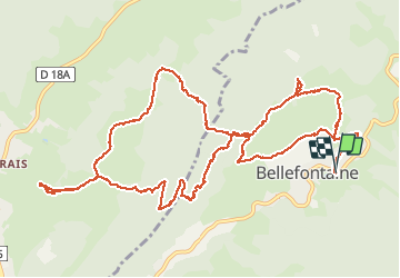
Randonnée Raquettes à neige de 16,9 km à découvrir à Bourgogne-Franche-Comté, Jura, Bellefontaine. Cette randonnée est proposée par albert39.
Description
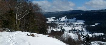
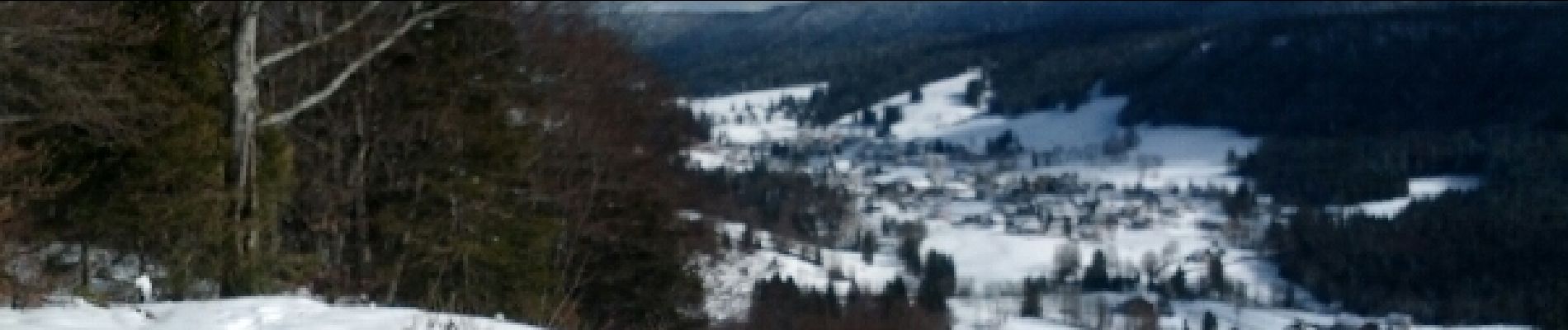
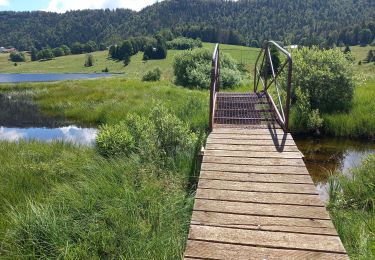
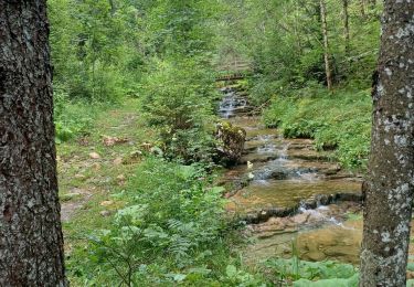
Superbe journée ensoleillée. Départ parking Téléski, le Clos, belvédère la Roche Devant, descente sur le stade et casse croûte salle hors sac, retour par le Chalet Pécaud et le bois de Chaux Mourant, Statue Sacré Cœur et parking.
Localisation
Pays :
France
Région :
Bourgogne-Franche-Comté
Département/Province :
Jura
Commune :
Bellefontaine
Localité :
Unknown
Départ:(Dec)
Départ:(UTM)
275362 ; 5160237 (32T) N.
Commentaires
Randonnées à proximité
![Randonnée Marche Chapelle-des-Bois - roche Bernard - Photo](https://media.geolcdn.com/t/375/260/ext.jpg?maxdim=2&url=https%3A%2F%2Fservices.sitytrail.com%2FGeolivesWS%2FDownloadMedia.ashx%3FTrailID%3D314677%26Media%3D20140620142657.jpg)
![Marche Marche](https://static1.geolcdn.com/sitytour/trail-icons/101.png)
roche Bernard
Marche
Moyen
(1)
Chapelle-des-Bois,
Bourgogne-Franche-Comté,
Doubs,
France
![](/images/other/stat-length.png)
15 km | 21 km-effort
4h 33min
![](https://static1.geolcdn.com/siteimages/upload/files/16400158638029165_repeat_loop_refresh_sync_direction_icon.png)
Oui
![Randonnée Marche Chapelle-des-Bois - ROCHE CHAMPION - Photo](https://media.geolcdn.com/t/375/260/ext.jpg?maxdim=2&url=https%3A%2F%2Fservices.sitytrail.com%2FGeolivesWS%2FDownloadMedia.ashx%3FTrailID%3D357205%26Media%3Dfix__20141026130524.jpg)
![Marche Marche](https://static1.geolcdn.com/sitytour/trail-icons/101.png)
ROCHE CHAMPION
Marche
Facile
(2)
Chapelle-des-Bois,
Bourgogne-Franche-Comté,
Doubs,
France
![](/images/other/stat-length.png)
8,6 km | 13,6 km-effort
1h 50min
![](https://static1.geolcdn.com/siteimages/upload/files/16400158638029165_repeat_loop_refresh_sync_direction_icon.png)
Oui
![Randonnée Marche Bellefontaine - Lac de Bellefontaine er lac des Mortes . - Photo](https://media.geolcdn.com/t/375/260/7671d781-54af-47e4-b735-a1a3fd8960ba.jpg&format=jpg&maxdim=2)
![Marche Marche](https://static1.geolcdn.com/sitytour/trail-icons/101.png)
Lac de Bellefontaine er lac des Mortes .
Marche
Facile
Bellefontaine,
Bourgogne-Franche-Comté,
Jura,
France
![](/images/other/stat-length.png)
9,5 km | 11,5 km-effort
2h 33min
![](https://static1.geolcdn.com/siteimages/upload/files/16400158638029165_repeat_loop_refresh_sync_direction_icon.png)
Oui
![Randonnée Marche Hauts de Bienne - Le Trou Bleu 11.7.23 - Photo](https://media.geolcdn.com/t/375/260/32941ccf-bc70-4062-9de5-a6e8a257842a.jpg&format=jpg&maxdim=2)
![Marche Marche](https://static1.geolcdn.com/sitytour/trail-icons/101.png)
Le Trou Bleu 11.7.23
Marche
Facile
Hauts de Bienne,
Bourgogne-Franche-Comté,
Jura,
France
![](/images/other/stat-length.png)
3,9 km | 5,3 km-effort
1h 15min
![](https://static1.geolcdn.com/siteimages/upload/files/16400158638029165_repeat_loop_refresh_sync_direction_icon.png)
Oui
![Randonnée Marche Chapelle-des-Bois - Roche Champion et Bernard 11.7.24 - Photo](https://media.geolcdn.com/t/375/260/0e6e22cc-0313-48ed-a610-26f870c14444.jpg&format=jpg&maxdim=2)
![Marche Marche](https://static1.geolcdn.com/sitytour/trail-icons/101.png)
Roche Champion et Bernard 11.7.24
Marche
Moyen
Chapelle-des-Bois,
Bourgogne-Franche-Comté,
Doubs,
France
![](/images/other/stat-length.png)
11,5 km | 16,6 km-effort
3h 45min
![](https://static1.geolcdn.com/siteimages/upload/files/16400158638029165_repeat_loop_refresh_sync_direction_icon.png)
Oui
![Randonnée Marche Bellefontaine - Pichonnier-Peraillet- village par l'Évalude - Photo](https://media.geolcdn.com/t/375/260/a5d97e4a-8813-4957-9f75-ff2855599f4e.jpg&format=jpg&maxdim=2)
![Marche Marche](https://static1.geolcdn.com/sitytour/trail-icons/101.png)
Pichonnier-Peraillet- village par l'Évalude
Marche
Difficile
Bellefontaine,
Bourgogne-Franche-Comté,
Jura,
France
![](/images/other/stat-length.png)
5,4 km | 7,5 km-effort
1h 53min
![](https://static1.geolcdn.com/siteimages/upload/files/16400158638029165_repeat_loop_refresh_sync_direction_icon.png)
Oui
![Randonnée V.T.C. Chapelle-des-Bois - Risoux - Photo](https://media.geolcdn.com/t/375/260/ext.jpg?maxdim=2&url=https%3A%2F%2Fstatic1.geolcdn.com%2Fsiteimages%2Fupload%2Ffiles%2F1524743154velo.jpg)
![V.T.C. V.T.C.](https://static1.geolcdn.com/sitytour/trail-icons/203.png)
Risoux
V.T.C.
Très facile
(1)
Chapelle-des-Bois,
Bourgogne-Franche-Comté,
Doubs,
France
![](/images/other/stat-length.png)
21 km | 27 km-effort
2h 0min
![](https://static1.geolcdn.com/siteimages/upload/files/16400158638029165_repeat_loop_refresh_sync_direction_icon.png)
Non
![Randonnée Raquettes à neige Chapelle-des-Bois - Chapelle 6.5 km 20240114 - Photo](https://media.geolcdn.com/t/375/260/ext.jpg?maxdim=2&url=https%3A%2F%2Fstatic1.geolcdn.com%2Fsiteimages%2Fupload%2Ffiles%2F1524743153raquette.jpg)
![Raquettes à neige Raquettes à neige](https://static1.geolcdn.com/sitytour/trail-icons/504.png)
Chapelle 6.5 km 20240114
Raquettes à neige
Très facile
(1)
Chapelle-des-Bois,
Bourgogne-Franche-Comté,
Doubs,
France
![](/images/other/stat-length.png)
6,5 km | 8,5 km-effort
1h 36min
![](https://static1.geolcdn.com/siteimages/upload/files/16400158638029165_repeat_loop_refresh_sync_direction_icon.png)
Oui
![Randonnée Marche Bellefontaine - Des lacs de Bellefontaine vers le belvédère de la roche Bernard. - Photo](https://media.geolcdn.com/t/375/260/4c61fcfd-b428-4bd3-b76a-55bf7607b035.jpg&format=jpg&maxdim=2)
![Marche Marche](https://static1.geolcdn.com/sitytour/trail-icons/101.png)
Des lacs de Bellefontaine vers le belvédère de la roche Bernard.
Marche
Difficile
Bellefontaine,
Bourgogne-Franche-Comté,
Jura,
France
![](/images/other/stat-length.png)
5,8 km | 8,7 km-effort
1h 53min
![](https://static1.geolcdn.com/siteimages/upload/files/16400158638029165_repeat_loop_refresh_sync_direction_icon.png)
Oui