![](/images/other/stat-length.png)
![Randonnée Marche Bethmale - ayet Bethmale - Photo](https://media.geolcdn.com/t/1900/400/ext.pjpeg?maxdim=2&url=https%3A%2F%2Fstatic1.geolcdn.com%2Fsiteimages%2Fupload%2Ffiles%2F1553511878bg_sport_marche.png)
ayet Bethmale
pidjam
Utilisateur
![Longueur](/images/other/stat-length.png)
Longueur
11,1 km
![Altitude max](https://static1.geolcdn.com/siteimages/upload/files/1508320355ic_sort_altitude_max_24dp.png)
Altitude max
1092 m
![Dénivelé positif](https://static1.geolcdn.com/siteimages/upload/files/1508320355ic_sort_den_pos_24dp.png)
Dénivelé positif
470 m
![Km-Effort](/images/other/stat-length.png)
Km-Effort
17,3 km
![Altitude min](https://static1.geolcdn.com/siteimages/upload/files/1508320355ic_sort_altitude_min_24dp.png)
Altitude min
715 m
![Dénivelé négatif](https://static1.geolcdn.com/siteimages/upload/files/1508320355ic_sort_den_neg_24dp.png)
Dénivelé négatif
469 m
![Boucle](https://static1.geolcdn.com/siteimages/upload/files/16400158638029165_repeat_loop_refresh_sync_direction_icon.png)
Boucle
Oui
Date de création :
2020-08-15 07:31:49.839
Dernière modification :
2020-08-15 18:38:36.299
![Marche](https://static1.geolcdn.com/sitytour/trail-icons/101.png)
3h40
Difficulté : Moyen
![Scannez ce code QR pour ouvrir la randonnée dans l'application SityTrail](https://capi.geolives.com/qq0zvz2zws4bq2lad0pu/sitytour/trails/2515061/qr.png?size=200)
Application GPS de randonnée GRATUITE
À propos
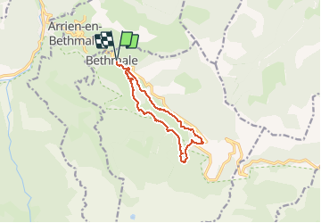
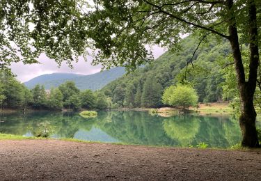
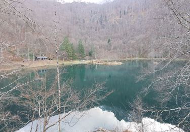
Randonnée Marche de 11,1 km à découvrir à Occitanie, Ariège, Bethmale. Cette randonnée est proposée par pidjam.
Description
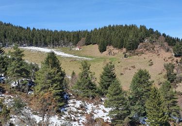
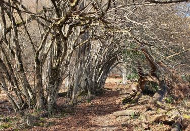
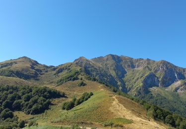
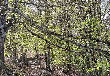
On monte depuis le parking d'Ayet jusqu'au lac de Bethmale par un PR, puis on revient par le GR10. La montée est aisée (pour tout âge), la descente par le GR10 puis le petit barreau de PR vers Ayet est plus technique (fortes pentes, dévers légers) mais sans difficulté par temps sec.
Localisation
Pays :
France
Région :
Occitanie
Département/Province :
Ariège
Commune :
Bethmale
Localité :
Unknown
Départ:(Dec)
Départ:(UTM)
341456 ; 4750256 (31T) N.
Commentaires
Randonnées à proximité
![Randonnée Marche Arrien-en-Bethmale - Les granges de la Serre depuis Tournac-La Bouche. - Photo](https://media.geolcdn.com/t/375/260/00f09377-3bad-4290-954b-9b185ed107d2.jpg&format=jpg&maxdim=2)
![Marche Marche](https://static1.geolcdn.com/sitytour/trail-icons/101.png)
Les granges de la Serre depuis Tournac-La Bouche.
Marche
Moyen
(1)
Arrien-en-Bethmale,
Occitanie,
Ariège,
France
![](/images/other/stat-length.png)
15 km | 26 km-effort
6h 39min
![](https://static1.geolcdn.com/siteimages/upload/files/16400158638029165_repeat_loop_refresh_sync_direction_icon.png)
Oui
![Randonnée Marche Bethmale - Bethmale - Photo](https://media.geolcdn.com/t/375/260/ext.jpg?maxdim=2&url=https%3A%2F%2Fservices.sitytrail.com%2FGeolivesWS%2FDownloadMedia.ashx%3FTrailID%3D205667%26Media%3Dfix__20130713122146.jpg)
![Marche Marche](https://static1.geolcdn.com/sitytour/trail-icons/101.png)
![Randonnée Marche Bethmale - Circuit des cinq étangs (2237m) - Photo](https://media.geolcdn.com/t/375/260/ext.jpg?maxdim=2&url=https%3A%2F%2Fstatic1.geolcdn.com%2Fsiteimages%2Fupload%2Ffiles%2F1553511878bg_sport_marche.png)
![Marche Marche](https://static1.geolcdn.com/sitytour/trail-icons/101.png)
Circuit des cinq étangs (2237m)
Marche
Difficile
(3)
Bethmale,
Occitanie,
Ariège,
France
![](/images/other/stat-length.png)
18,1 km | 33 km-effort
Inconnu
![](https://static1.geolcdn.com/siteimages/upload/files/16400158638029165_repeat_loop_refresh_sync_direction_icon.png)
Oui
![Randonnée Marche Salsein - Cabane et pic de l'Arraing depuis Salsein - Photo](https://media.geolcdn.com/t/375/260/f91c1032-feb4-41d1-b41d-2f82c72f5c13.jpg&format=jpg&maxdim=2)
![Marche Marche](https://static1.geolcdn.com/sitytour/trail-icons/101.png)
Cabane et pic de l'Arraing depuis Salsein
Marche
Moyen
Salsein,
Occitanie,
Ariège,
France
![](/images/other/stat-length.png)
11,7 km | 21 km-effort
4h 43min
![](https://static1.geolcdn.com/siteimages/upload/files/16400158638029165_repeat_loop_refresh_sync_direction_icon.png)
Oui
![Randonnée Marche Bethmale - Cap de Bouirex - Photo](https://media.geolcdn.com/t/375/260/cd5f9d82-9db3-4878-a9ba-18a6e8856ce6.jpg&format=jpg&maxdim=2)
![Marche Marche](https://static1.geolcdn.com/sitytour/trail-icons/101.png)
Cap de Bouirex
Marche
Difficile
Bethmale,
Occitanie,
Ariège,
France
![](/images/other/stat-length.png)
8,8 km | 16,1 km-effort
3h 18min
![](https://static1.geolcdn.com/siteimages/upload/files/16400158638029165_repeat_loop_refresh_sync_direction_icon.png)
Oui
![Randonnée Marche Bethmale - Col de la core - Photo](https://media.geolcdn.com/t/375/260/4994e3ec-bda9-4da3-924c-fcb0e68be84a.jpg&format=jpg&maxdim=2)
![Marche Marche](https://static1.geolcdn.com/sitytour/trail-icons/101.png)
Col de la core
Marche
Difficile
Bethmale,
Occitanie,
Ariège,
France
![](/images/other/stat-length.png)
15,6 km | 27 km-effort
5h 43min
![](https://static1.geolcdn.com/siteimages/upload/files/16400158638029165_repeat_loop_refresh_sync_direction_icon.png)
Oui
![Randonnée Marche Arrien-en-Bethmale - Les granges de la Serre depuis Tournac-Bouche. - Photo](https://media.geolcdn.com/t/375/260/7b3650fc-9802-48da-85b6-ffe6fc31c745.jpg&format=jpg&maxdim=2)
![Marche Marche](https://static1.geolcdn.com/sitytour/trail-icons/101.png)
Les granges de la Serre depuis Tournac-Bouche.
Marche
Moyen
Arrien-en-Bethmale,
Occitanie,
Ariège,
France
![](/images/other/stat-length.png)
14,6 km | 25 km-effort
7h 33min
![](https://static1.geolcdn.com/siteimages/upload/files/16400158638029165_repeat_loop_refresh_sync_direction_icon.png)
Oui
![Randonnée Marche Bethmale - refuge Salvador - Photo](https://media.geolcdn.com/t/375/260/41221468-6f9e-4614-8cc9-9cc4dfd6562d.jpg&format=jpg&maxdim=2)
![Marche Marche](https://static1.geolcdn.com/sitytour/trail-icons/101.png)
refuge Salvador
Marche
Très difficile
Bethmale,
Occitanie,
Ariège,
France
![](/images/other/stat-length.png)
16 km | 25 km-effort
5h 46min
![](https://static1.geolcdn.com/siteimages/upload/files/16400158638029165_repeat_loop_refresh_sync_direction_icon.png)
Oui
![Randonnée Marche Sentenac-d'Oust - 2020-08-25 col de la cor - col d'Auédole - étang d'Ayes - col d'Auédole - étang d'Eychelle - col de la core. - Photo](https://media.geolcdn.com/t/375/260/1d8e5b8e-ece0-4a83-9c05-d7dab1c422f8.jpg&format=jpg&maxdim=2)
![Marche Marche](https://static1.geolcdn.com/sitytour/trail-icons/101.png)
2020-08-25 col de la cor - col d'Auédole - étang d'Ayes - col d'Auédole - éta...
Marche
Difficile
(1)
Sentenac-d'Oust,
Occitanie,
Ariège,
France
![](/images/other/stat-length.png)
11,4 km | 21 km-effort
4h 16min
![](https://static1.geolcdn.com/siteimages/upload/files/16400158638029165_repeat_loop_refresh_sync_direction_icon.png)
Oui