![](/images/other/stat-length.png)
![Randonnée Marche Beersel - zennebeemd - Photo](https://media.geolcdn.com/t/1900/400/ext.pjpeg?maxdim=2&url=https%3A%2F%2Fstatic1.geolcdn.com%2Fsiteimages%2Fupload%2Ffiles%2F1553511878bg_sport_marche.png)
zennebeemd
jmpierlot
Utilisateur
![Longueur](/images/other/stat-length.png)
Longueur
4,4 km
![Altitude max](https://static1.geolcdn.com/siteimages/upload/files/1508320355ic_sort_altitude_max_24dp.png)
Altitude max
87 m
![Dénivelé positif](https://static1.geolcdn.com/siteimages/upload/files/1508320355ic_sort_den_pos_24dp.png)
Dénivelé positif
74 m
![Km-Effort](/images/other/stat-length.png)
Km-Effort
5,4 km
![Altitude min](https://static1.geolcdn.com/siteimages/upload/files/1508320355ic_sort_altitude_min_24dp.png)
Altitude min
19 m
![Dénivelé négatif](https://static1.geolcdn.com/siteimages/upload/files/1508320355ic_sort_den_neg_24dp.png)
Dénivelé négatif
61 m
![Boucle](https://static1.geolcdn.com/siteimages/upload/files/16400158638029165_repeat_loop_refresh_sync_direction_icon.png)
Boucle
Oui
Date de création :
2020-08-15 09:34:23.664
Dernière modification :
2020-08-15 15:55:06.981
![Marche](https://static1.geolcdn.com/sitytour/trail-icons/101.png)
1h26
Difficulté : Très facile
![Scannez ce code QR pour ouvrir la randonnée dans l'application SityTrail](https://capi.geolives.com/qq0zvz2zws4bq2lad0pu/sitytour/trails/2514742/qr.png?size=200)
Application GPS de randonnée GRATUITE
À propos
Randonnée Marche de 4,4 km à découvrir à Flandre, Brabant flamand, Beersel. Cette randonnée est proposée par jmpierlot.
Description
Une très belle balade le long de la Senne (le retour est un peu moins agréable car dans les petites rues de Beersel (où il y a par contre de nombreux restaurants, pour tous les goûts :-)
Localisation
Pays :
Belgique
Région :
Flandre
Département/Province :
Brabant flamand
Commune :
Beersel
Localité :
Beersel
Départ:(Dec)
Départ:(UTM)
592511 ; 5625932 (31U) N.
Commentaires
Randonnées à proximité
![Randonnée Marche Linkebeek - Linkebeek Perkhoeve en Peter Pan - 8 km RT - Photo](https://media.geolcdn.com/t/375/260/ext.jpg?maxdim=2&url=https%3A%2F%2Fstatic1.geolcdn.com%2Fsiteimages%2Fupload%2Ffiles%2F1553511878bg_sport_marche.png)
![Marche Marche](https://static1.geolcdn.com/sitytour/trail-icons/101.png)
Linkebeek Perkhoeve en Peter Pan - 8 km RT
Marche
Très facile
(5)
Linkebeek,
Flandre,
Brabant flamand,
Belgique
![](/images/other/stat-length.png)
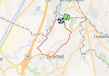
7,6 km | 9,3 km-effort
Inconnu
![](https://static1.geolcdn.com/siteimages/upload/files/16400158638029165_repeat_loop_refresh_sync_direction_icon.png)
Oui
![Randonnée Marche Forest - Forest National - Uccle - Photo](https://media.geolcdn.com/t/375/260/3deb4e32-c7c7-4612-9f7e-c6f2572a529a.jpg&format=jpg&maxdim=2)
![Marche Marche](https://static1.geolcdn.com/sitytour/trail-icons/101.png)
Forest National - Uccle
Marche
Facile
(1)
Forest,
Bruxelles-Capitale,
Inconnu,
Belgique
![](/images/other/stat-length.png)
9,6 km | 11,6 km-effort
2h 38min
![](https://static1.geolcdn.com/siteimages/upload/files/16400158638029165_repeat_loop_refresh_sync_direction_icon.png)
Oui
![Randonnée Marche Beersel - RL-GG-24_Beersel_Hennuyères - Photo](https://media.geolcdn.com/t/375/260/102ff410-776a-4c59-ae38-58c43777bc8a.jpg&format=jpg&maxdim=2)
![Marche Marche](https://static1.geolcdn.com/sitytour/trail-icons/101.png)
RL-GG-24_Beersel_Hennuyères
Marche
Moyen
(2)
Beersel,
Flandre,
Brabant flamand,
Belgique
![](/images/other/stat-length.png)
37 km | 47 km-effort
10h 44min
![](https://static1.geolcdn.com/siteimages/upload/files/16400158638029165_repeat_loop_refresh_sync_direction_icon.png)
Non
![Randonnée Marche Uccle - RB-Br-07-Rac01 - Photo](https://media.geolcdn.com/t/375/260/ext.jpg?maxdim=2&url=https%3A%2F%2Fservices.sitytrail.com%2FGeolivesWS%2FDownloadMedia.ashx%3FTrailID%3D247895%26Media%3Df2f46971-c44e-4a53-867b-6dea0848e49c.jpg)
![Marche Marche](https://static1.geolcdn.com/sitytour/trail-icons/101.png)
RB-Br-07-Rac01
Marche
Facile
(6)
Uccle,
Bruxelles-Capitale,
Inconnu,
Belgique
![](/images/other/stat-length.png)
16,9 km | 20 km-effort
4h 36min
![](https://static1.geolcdn.com/siteimages/upload/files/16400158638029165_repeat_loop_refresh_sync_direction_icon.png)
Oui
![Randonnée Marche Uccle - RB-Br-07 - Photo](https://media.geolcdn.com/t/375/260/ext.jpg?maxdim=2&url=https%3A%2F%2Fservices.sitytrail.com%2FGeolivesWS%2FDownloadMedia.ashx%3FTrailID%3D247894%26Media%3Df2f46971-c44e-4a53-867b-6dea0848e49c.jpg)
![Marche Marche](https://static1.geolcdn.com/sitytour/trail-icons/101.png)
RB-Br-07
Marche
Difficile
(4)
Uccle,
Bruxelles-Capitale,
Inconnu,
Belgique
![](/images/other/stat-length.png)
26 km | 33 km-effort
7h 23min
![](https://static1.geolcdn.com/siteimages/upload/files/16400158638029165_repeat_loop_refresh_sync_direction_icon.png)
Oui
![Randonnée Marche Beersel - Beersel 10km - Photo](https://media.geolcdn.com/t/375/260/4be021b0-0611-495b-8c11-6bedba66a35d.jpg&format=jpg&maxdim=2)
![Marche Marche](https://static1.geolcdn.com/sitytour/trail-icons/101.png)
Beersel 10km
Marche
Moyen
(2)
Beersel,
Flandre,
Brabant flamand,
Belgique
![](/images/other/stat-length.png)
10,5 km | 13,1 km-effort
2h 34min
![](https://static1.geolcdn.com/siteimages/upload/files/16400158638029165_repeat_loop_refresh_sync_direction_icon.png)
Oui
![Randonnée Marche Ville de Bruxelles - Bois de la Cambre-Foret des Soignes-la Hulpe - Photo](https://media.geolcdn.com/t/375/260/bfe239fb-9a36-468d-8ae7-40686b2e5839.jpg&format=jpg&maxdim=2)
![Marche Marche](https://static1.geolcdn.com/sitytour/trail-icons/101.png)
Bois de la Cambre-Foret des Soignes-la Hulpe
Marche
Facile
(1)
Ville de Bruxelles,
Bruxelles-Capitale,
Inconnu,
Belgique
![](/images/other/stat-length.png)
16,6 km | 19,5 km-effort
3h 13min
![](https://static1.geolcdn.com/siteimages/upload/files/16400158638029165_repeat_loop_refresh_sync_direction_icon.png)
Non
![Randonnée Marche Beersel - 2019-01-10 Boucle Huizingen 22 km - Photo](https://media.geolcdn.com/t/375/260/8543774e-ca92-454e-9fd7-9ac7878ef135.jpg&format=jpg&maxdim=2)
![Marche Marche](https://static1.geolcdn.com/sitytour/trail-icons/101.png)
2019-01-10 Boucle Huizingen 22 km
Marche
Très facile
(1)
Beersel,
Flandre,
Brabant flamand,
Belgique
![](/images/other/stat-length.png)
22 km | 27 km-effort
4h 38min
![](https://static1.geolcdn.com/siteimages/upload/files/16400158638029165_repeat_loop_refresh_sync_direction_icon.png)
Oui
![Randonnée Marche Beersel - Entre Beersel et Dworp - Photo](https://media.geolcdn.com/t/375/260/ext.jpg?maxdim=2&url=https%3A%2F%2Fservices.sitytrail.com%2FGeolivesWS%2FDownloadMedia.ashx%3FTrailID%3D310076%26Media%3D3efa6535-4846-4e23-9c11-65c16b69488b.jpg)
![Marche Marche](https://static1.geolcdn.com/sitytour/trail-icons/101.png)
Entre Beersel et Dworp
Marche
Moyen
(1)
Beersel,
Flandre,
Brabant flamand,
Belgique
![](/images/other/stat-length.png)
10,1 km | 13 km-effort
2h 45min
![](https://static1.geolcdn.com/siteimages/upload/files/16400158638029165_repeat_loop_refresh_sync_direction_icon.png)
Oui