![](/images/other/stat-length.png)
![Randonnée Marche Bourg-Saint-Maurice - Les Arcs 1600 - Les Arcs 1800 par le grand balcon et la route des Espagnols - Photo](https://media.geolcdn.com/t/1900/400/ext.pjpeg?maxdim=2&url=https%3A%2F%2Fstatic1.geolcdn.com%2Fsiteimages%2Fupload%2Ffiles%2F1553511878bg_sport_marche.png)
Les Arcs 1600 - Les Arcs 1800 par le grand balcon et la route des Espagnols
gilsep
Utilisateur
![Longueur](/images/other/stat-length.png)
![Altitude max](https://static1.geolcdn.com/siteimages/upload/files/1508320355ic_sort_altitude_max_24dp.png)
![Dénivelé positif](https://static1.geolcdn.com/siteimages/upload/files/1508320355ic_sort_den_pos_24dp.png)
![Km-Effort](/images/other/stat-length.png)
![Altitude min](https://static1.geolcdn.com/siteimages/upload/files/1508320355ic_sort_altitude_min_24dp.png)
![Dénivelé négatif](https://static1.geolcdn.com/siteimages/upload/files/1508320355ic_sort_den_neg_24dp.png)
![Boucle](https://static1.geolcdn.com/siteimages/upload/files/16400158638029165_repeat_loop_refresh_sync_direction_icon.png)
![Marche](https://static1.geolcdn.com/sitytour/trail-icons/101.png)
2h23
Difficulté : Facile
![Scannez ce code QR pour ouvrir la randonnée dans l'application SityTrail](https://capi.geolives.com/qq0zvz2zws4bq2lad0pu/sitytour/trails/2513517/qr.png?size=200)
Application GPS de randonnée GRATUITE
À propos
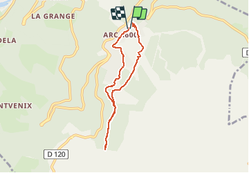
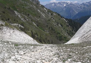
Randonnée Marche de 6,3 km à découvrir à Auvergne-Rhône-Alpes, Savoie, Bourg-Saint-Maurice. Cette randonnée est proposée par gilsep.
Description
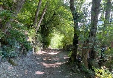
Départ du funiculaire. Suivre l'itinéraire fléché en jaune. Promenade à l'ombre le matin jusqu'aux Arcs 1800. Retour au funiculaire par la route des Espagnols.
Jolies vues. Pas de difficulté particulière. Attention aux vélos qui roulent comme des dingues.
Localisation
Commentaires
Randonnées à proximité
![Randonnée Marche Landry - Landry... Circuit des Poussettes - Photo](https://media.geolcdn.com/t/375/260/7036f5a0-5897-408b-aec5-74b6e9af163d.jpeg&format=jpg&maxdim=2)
![Marche Marche](https://static1.geolcdn.com/sitytour/trail-icons/101.png)
Marche
![](/images/other/stat-length.png)
![](https://static1.geolcdn.com/siteimages/upload/files/16400158638029165_repeat_loop_refresh_sync_direction_icon.png)
![Randonnée Marche Bourg-Saint-Maurice - 73 Tarentaise - Sentier balcon des sources de l'Arbonne - Photo](https://media.geolcdn.com/t/375/260/ext.jpg?maxdim=2&url=https%3A%2F%2Fstatic1.geolcdn.com%2Fsiteimages%2Fupload%2Ffiles%2F1553511878bg_sport_marche.png)
![Marche Marche](https://static1.geolcdn.com/sitytour/trail-icons/101.png)
Marche
![](/images/other/stat-length.png)
![](https://static1.geolcdn.com/siteimages/upload/files/16400158638029165_repeat_loop_refresh_sync_direction_icon.png)
![Randonnée Ski de randonnée Bourg-Saint-Maurice - petite Aiguille de Praina - Photo](https://media.geolcdn.com/t/375/260/e105a7db-c885-44d0-a320-0f42ca59ba71.jpg&format=jpg&maxdim=2)
![Ski de randonnée Ski de randonnée](https://static1.geolcdn.com/sitytour/trail-icons/503.png)
Ski de randonnée
![](/images/other/stat-length.png)
![](https://static1.geolcdn.com/siteimages/upload/files/16400158638029165_repeat_loop_refresh_sync_direction_icon.png)
![Randonnée Ski de randonnée Bourg-Saint-Maurice - La Torche en boucle - Photo](https://media.geolcdn.com/t/375/260/18108b5f-6eb9-4481-a712-c62c16cbdb0d.jpg&format=jpg&maxdim=2)
![Ski de randonnée Ski de randonnée](https://static1.geolcdn.com/sitytour/trail-icons/503.png)
Ski de randonnée
![](/images/other/stat-length.png)
![](https://static1.geolcdn.com/siteimages/upload/files/16400158638029165_repeat_loop_refresh_sync_direction_icon.png)
![Randonnée Ski de randonnée Bourg-Saint-Maurice - Aiguille de Praina - Photo](https://media.geolcdn.com/t/375/260/8f6edc41-81d2-4218-97fb-5820c73f8bc2.jpg&format=jpg&maxdim=2)
![Ski de randonnée Ski de randonnée](https://static1.geolcdn.com/sitytour/trail-icons/503.png)
Ski de randonnée
![](/images/other/stat-length.png)
![](https://static1.geolcdn.com/siteimages/upload/files/16400158638029165_repeat_loop_refresh_sync_direction_icon.png)
![Randonnée Ski de randonnée Bourg-Saint-Maurice - Le grand Châtelet Est en boucle - Photo](https://media.geolcdn.com/t/375/260/6b25a155-1df9-4a43-bfdb-3a7483c7ae4a.jpg&format=jpg&maxdim=2)
![Ski de randonnée Ski de randonnée](https://static1.geolcdn.com/sitytour/trail-icons/503.png)
Ski de randonnée
![](/images/other/stat-length.png)
![](https://static1.geolcdn.com/siteimages/upload/files/16400158638029165_repeat_loop_refresh_sync_direction_icon.png)
![Randonnée Ski de randonnée Bourg-Saint-Maurice - pointe de la combe neuve et Roc de l'enfer - Photo](https://media.geolcdn.com/t/375/260/c5014259-c6d5-4d86-8bfd-ce07a14ec173.jpg&format=jpg&maxdim=2)
![Ski de randonnée Ski de randonnée](https://static1.geolcdn.com/sitytour/trail-icons/503.png)
Ski de randonnée
![](/images/other/stat-length.png)
![](https://static1.geolcdn.com/siteimages/upload/files/16400158638029165_repeat_loop_refresh_sync_direction_icon.png)
![Randonnée Ski de randonnée Bourg-Saint-Maurice - col des roches vers le Pourri - Photo](https://media.geolcdn.com/t/375/260/1b6a1c42-133a-4e34-bc5c-807990c98faf.jpg&format=jpg&maxdim=2)
![Ski de randonnée Ski de randonnée](https://static1.geolcdn.com/sitytour/trail-icons/503.png)
Ski de randonnée
![](/images/other/stat-length.png)
![](https://static1.geolcdn.com/siteimages/upload/files/16400158638029165_repeat_loop_refresh_sync_direction_icon.png)
![Randonnée Marche Bourg-Saint-Maurice - arc 1950 col des frettes arc 1800 station internationale - Photo](https://media.geolcdn.com/t/375/260/f895417e-d75f-415c-875d-31cc9f0b4878.jpg&format=jpg&maxdim=2)
![Marche Marche](https://static1.geolcdn.com/sitytour/trail-icons/101.png)
Marche
![](/images/other/stat-length.png)
![](https://static1.geolcdn.com/siteimages/upload/files/16400158638029165_repeat_loop_refresh_sync_direction_icon.png)