![](/images/other/stat-length.png)
Col de la Noire
astro45
Utilisateur
![Longueur](/images/other/stat-length.png)
Longueur
2,3 km
![Altitude max](https://static1.geolcdn.com/siteimages/upload/files/1508320355ic_sort_altitude_max_24dp.png)
Altitude max
2951 m
![Dénivelé positif](https://static1.geolcdn.com/siteimages/upload/files/1508320355ic_sort_den_pos_24dp.png)
Dénivelé positif
467 m
![Km-Effort](/images/other/stat-length.png)
Km-Effort
7 km
![Altitude min](https://static1.geolcdn.com/siteimages/upload/files/1508320355ic_sort_altitude_min_24dp.png)
Altitude min
2498 m
![Dénivelé négatif](https://static1.geolcdn.com/siteimages/upload/files/1508320355ic_sort_den_neg_24dp.png)
Dénivelé négatif
24 m
![Boucle](https://static1.geolcdn.com/siteimages/upload/files/16400158638029165_repeat_loop_refresh_sync_direction_icon.png)
Boucle
Non
Date de création :
2020-08-13 06:09:04.0
Dernière modification :
2021-07-28 17:04:34.421
![Marche](https://static1.geolcdn.com/sitytour/trail-icons/101.png)
3h27
Difficulté : Moyen
![Scannez ce code QR pour ouvrir la randonnée dans l'application SityTrail](https://capi.geolives.com/qq0zvz2zws4bq2lad0pu/sitytour/trails/2513114/qr.png?size=200)
Application GPS de randonnée GRATUITE
À propos
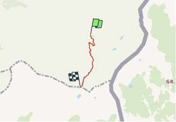
Randonnée Marche de 2,3 km à découvrir à Provence-Alpes-Côte d'Azur, Hautes-Alpes, Saint-Véran. Cette randonnée est proposée par astro45.
Description
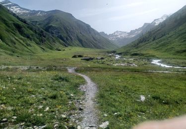
Montée au col de la Noire depuis le refuge de la Blanche.
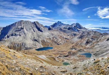
Belle vue sur le lac de la Noire.
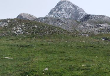
Possibilité de monter au Pic de la Farneiréta.
Localisation
Pays :
France
Région :
Provence-Alpes-Côte d'Azur
Département/Province :
Hautes-Alpes
Commune :
Saint-Véran
Localité :
Unknown
Départ:(Dec)
Départ:(UTM)
336763 ; 4947967 (32T) N.
Commentaires
Randonnées à proximité
![Randonnée Marche Saint-Véran - Lac de la Blanche, lacs blanchet et pic de Caramantran - Photo](https://media.geolcdn.com/t/375/260/ext.jpg?maxdim=2&url=https%3A%2F%2Fservices.sitytrail.com%2FGeolivesWS%2FDownloadMedia.ashx%3FTrailID%3D596077%26Media%3Dfix__20160710142025.jpg)
![Marche Marche](https://static1.geolcdn.com/sitytour/trail-icons/101.png)
Lac de la Blanche, lacs blanchet et pic de Caramantran
Marche
Moyen
(2)
Saint-Véran,
Provence-Alpes-Côte d'Azur,
Hautes-Alpes,
France
![](/images/other/stat-length.png)
13,1 km | 23 km-effort
6h 12min
![](https://static1.geolcdn.com/siteimages/upload/files/16400158638029165_repeat_loop_refresh_sync_direction_icon.png)
Oui
![Randonnée Marche Pontechianale - ITALIE BELLINO CHIANALE . TOUR DU PAIN DU SUCRE . AR. O - Photo](https://media.geolcdn.com/t/375/260/605ee47c-e413-41ea-82a5-10806d48b77c.jpg&format=jpg&maxdim=2)
![Marche Marche](https://static1.geolcdn.com/sitytour/trail-icons/101.png)
ITALIE BELLINO CHIANALE . TOUR DU PAIN DU SUCRE . AR. O
Marche
Moyen
Pontechianale,
Piémont,
Coni,
Italie
![](/images/other/stat-length.png)
7,7 km | 11,3 km-effort
2h 36min
![](https://static1.geolcdn.com/siteimages/upload/files/16400158638029165_repeat_loop_refresh_sync_direction_icon.png)
Oui
![Randonnée Marche Molines-en-Queyras - le tour du Pain de Sucre - Photo](https://media.geolcdn.com/t/375/260/ext.jpg?maxdim=2&url=https%3A%2F%2Fservices.sitytrail.com%2FGeolivesWS%2FDownloadMedia.ashx%3FTrailID%3D820382%26Media%3Dfix__20170830144825.jpg)
![Marche Marche](https://static1.geolcdn.com/sitytour/trail-icons/101.png)
le tour du Pain de Sucre
Marche
Difficile
Molines-en-Queyras,
Provence-Alpes-Côte d'Azur,
Hautes-Alpes,
France
![](/images/other/stat-length.png)
8,1 km | 16 km-effort
4h 57min
![](https://static1.geolcdn.com/siteimages/upload/files/16400158638029165_repeat_loop_refresh_sync_direction_icon.png)
Oui
![Randonnée Marche Saint-Véran - Pic de Caramantran - Photo](https://media.geolcdn.com/t/375/260/ext.jpg?maxdim=2&url=https%3A%2F%2Fservices.sitytrail.com%2FGeolivesWS%2FDownloadMedia.ashx%3FTrailID%3D629317%26Media%3D93967439-727d-490c-bf0f-c5937248e7c8.jpg)
![Marche Marche](https://static1.geolcdn.com/sitytour/trail-icons/101.png)
Pic de Caramantran
Marche
Très difficile
Saint-Véran,
Provence-Alpes-Côte d'Azur,
Hautes-Alpes,
France
![](/images/other/stat-length.png)
12 km | 23 km-effort
4h 41min
![](https://static1.geolcdn.com/siteimages/upload/files/16400158638029165_repeat_loop_refresh_sync_direction_icon.png)
Oui
![Randonnée Marche Molines-en-Queyras - Lacs Foréant, Egorgéou, Baricle et de l'Eychassier - Photo](https://media.geolcdn.com/t/375/260/ext.jpg?maxdim=2&url=https%3A%2F%2Fservices.sitytrail.com%2FGeolivesWS%2FDownloadMedia.ashx%3FTrailID%3D597581%26Media%3Dfix__20160713160454.jpg)
![Marche Marche](https://static1.geolcdn.com/sitytour/trail-icons/101.png)
Lacs Foréant, Egorgéou, Baricle et de l'Eychassier
Marche
Moyen
Molines-en-Queyras,
Provence-Alpes-Côte d'Azur,
Hautes-Alpes,
France
![](/images/other/stat-length.png)
13,8 km | 24 km-effort
6h 20min
![](https://static1.geolcdn.com/siteimages/upload/files/16400158638029165_repeat_loop_refresh_sync_direction_icon.png)
Oui
![Randonnée Marche Molines-en-Queyras - le pain de sucre - Photo](https://media.geolcdn.com/t/375/260/ext.jpg?maxdim=2&url=https%3A%2F%2Fservices.sitytrail.com%2FGeolivesWS%2FDownloadMedia.ashx%3FTrailID%3D444362%26Media%3Dfix__20150712140232.jpg)
![Marche Marche](https://static1.geolcdn.com/sitytour/trail-icons/101.png)
le pain de sucre
Marche
Difficile
(1)
Molines-en-Queyras,
Provence-Alpes-Côte d'Azur,
Hautes-Alpes,
France
![](/images/other/stat-length.png)
4,5 km | 10,1 km-effort
4h 39min
![](https://static1.geolcdn.com/siteimages/upload/files/16400158638029165_repeat_loop_refresh_sync_direction_icon.png)
Oui
![Randonnée Marche Pontechianale - pain de sucre circuit - Photo](https://media.geolcdn.com/t/375/260/765c798f-47ae-4e08-a9cf-50bd35561578.jpg&format=jpg&maxdim=2)
![Marche Marche](https://static1.geolcdn.com/sitytour/trail-icons/101.png)
pain de sucre circuit
Marche
Moyen
Pontechianale,
Piémont,
Coni,
Italie
![](/images/other/stat-length.png)
5,9 km | 11,9 km-effort
2h 12min
![](https://static1.geolcdn.com/siteimages/upload/files/16400158638029165_repeat_loop_refresh_sync_direction_icon.png)
Non
![Randonnée Marche Molines-en-Queyras - Pic Foréant et Col d'Asti - Photo](https://media.geolcdn.com/t/375/260/0a0f75bf-b7eb-4c17-be04-8e1330cfc2d9.jpg&format=jpg&maxdim=2)
![Marche Marche](https://static1.geolcdn.com/sitytour/trail-icons/101.png)
Pic Foréant et Col d'Asti
Marche
Très difficile
Molines-en-Queyras,
Provence-Alpes-Côte d'Azur,
Hautes-Alpes,
France
![](/images/other/stat-length.png)
11,8 km | 24 km-effort
7h 14min
![](https://static1.geolcdn.com/siteimages/upload/files/16400158638029165_repeat_loop_refresh_sync_direction_icon.png)
Non
![Randonnée Marche Molines-en-Queyras - 05-Pain-de-sucre-6.5km-525m-aout21 - Photo](https://media.geolcdn.com/t/375/260/7e381716-a2f4-4b1d-8463-85a8f85532fe.jpg&format=jpg&maxdim=2)
![Marche Marche](https://static1.geolcdn.com/sitytour/trail-icons/101.png)
05-Pain-de-sucre-6.5km-525m-aout21
Marche
Moyen
Molines-en-Queyras,
Provence-Alpes-Côte d'Azur,
Hautes-Alpes,
France
![](/images/other/stat-length.png)
6,5 km | 13,5 km-effort
4h 14min
![](https://static1.geolcdn.com/siteimages/upload/files/16400158638029165_repeat_loop_refresh_sync_direction_icon.png)
Oui