![](/images/other/stat-length.png)
![Randonnée A pied Leyrieu - CHAPELLE LEYRIEU - Photo](https://media.geolcdn.com/t/1900/400/ext.pjpeg?maxdim=2&url=https%3A%2F%2Fstatic1.geolcdn.com%2Fsiteimages%2Fupload%2Ffiles%2F1545311037marcheuse_200dpi.jpg)
CHAPELLE LEYRIEU
Christophe Ontavilla
Utilisateur
![Longueur](/images/other/stat-length.png)
Longueur
11,8 km
![Altitude max](https://static1.geolcdn.com/siteimages/upload/files/1508320355ic_sort_altitude_max_24dp.png)
Altitude max
421 m
![Dénivelé positif](https://static1.geolcdn.com/siteimages/upload/files/1508320355ic_sort_den_pos_24dp.png)
Dénivelé positif
274 m
![Km-Effort](/images/other/stat-length.png)
Km-Effort
15,5 km
![Altitude min](https://static1.geolcdn.com/siteimages/upload/files/1508320355ic_sort_altitude_min_24dp.png)
Altitude min
237 m
![Dénivelé négatif](https://static1.geolcdn.com/siteimages/upload/files/1508320355ic_sort_den_neg_24dp.png)
Dénivelé négatif
274 m
![Boucle](https://static1.geolcdn.com/siteimages/upload/files/16400158638029165_repeat_loop_refresh_sync_direction_icon.png)
Boucle
Oui
Date de création :
2020-08-13 14:28:00.971
Dernière modification :
2020-08-17 14:42:41.556
![A pied](https://static1.geolcdn.com/sitytour/trail-icons/100.png)
--
Difficulté : Facile
![Scannez ce code QR pour ouvrir la randonnée dans l'application SityTrail](https://capi.geolives.com/qq0zvz2zws4bq2lad0pu/sitytour/trails/2512561/qr.png?size=200)
Application GPS de randonnée GRATUITE
À propos
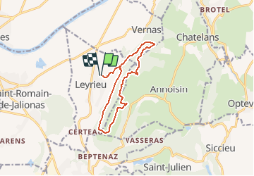
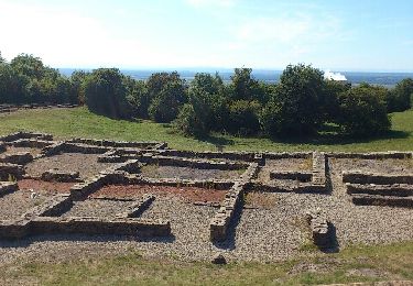
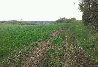
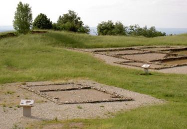
Randonnée A pied de 11,8 km à découvrir à Auvergne-Rhône-Alpes, Isère, Leyrieu. Cette randonnée est proposée par Christophe Ontavilla.
Description
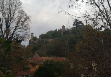
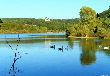
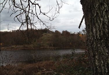
départ du village avec de jolie maison de pierre et après une montée en sous bois vous dominerez la plaine de l'est lyonnais
Localisation
Pays :
France
Région :
Auvergne-Rhône-Alpes
Département/Province :
Isère
Commune :
Leyrieu
Localité :
Unknown
Départ:(Dec)
Départ:(UTM)
675676 ; 5069928 (31T) N.
Commentaires
Randonnées à proximité
![Randonnée Marche Siccieu-Saint-Julien-et-Carisieu - Etang-de-Ry Siccieu 10km 245m - Photo](https://media.geolcdn.com/t/375/260/ext.jpg?maxdim=2&url=https%3A%2F%2Fstatic1.geolcdn.com%2Fsiteimages%2Fupload%2Ffiles%2F1553511878bg_sport_marche.png)
![Marche Marche](https://static1.geolcdn.com/sitytour/trail-icons/101.png)
Etang-de-Ry Siccieu 10km 245m
Marche
Facile
(1)
Siccieu-Saint-Julien-et-Carisieu,
Auvergne-Rhône-Alpes,
Isère,
France
![](/images/other/stat-length.png)
9,8 km | 13,1 km-effort
3h 0min
![](https://static1.geolcdn.com/siteimages/upload/files/16400158638029165_repeat_loop_refresh_sync_direction_icon.png)
Oui
![Randonnée A pied Annoisin-Chatelans - Chatelans (Larina) 10.7 km - Photo](https://media.geolcdn.com/t/375/260/ext.jpg?maxdim=2&url=https%3A%2F%2Fstatic1.geolcdn.com%2Fsiteimages%2Fupload%2Ffiles%2F1545311037marcheuse_200dpi.jpg)
![A pied A pied](https://static1.geolcdn.com/sitytour/trail-icons/100.png)
Chatelans (Larina) 10.7 km
A pied
Facile
(1)
Annoisin-Chatelans,
Auvergne-Rhône-Alpes,
Isère,
France
![](/images/other/stat-length.png)
10,7 km | 13,8 km-effort
3h 8min
![](https://static1.geolcdn.com/siteimages/upload/files/16400158638029165_repeat_loop_refresh_sync_direction_icon.png)
Oui
![Randonnée V.T.T. Crémieu - Voie verte Crémieu Arandon - Photo](https://media.geolcdn.com/t/375/260/7ee3f5d9-f7a0-4654-ad0b-435de811c610.jpg&format=jpg&maxdim=2)
![V.T.T. V.T.T.](https://static1.geolcdn.com/sitytour/trail-icons/202.png)
Voie verte Crémieu Arandon
V.T.T.
Très facile
Crémieu,
Auvergne-Rhône-Alpes,
Isère,
France
![](/images/other/stat-length.png)
41 km | 45 km-effort
3h 11min
![](https://static1.geolcdn.com/siteimages/upload/files/16400158638029165_repeat_loop_refresh_sync_direction_icon.png)
Oui
![Randonnée V.T.T. Crémieu - Le mémorial des aviateurs - Crémieu - Photo](https://media.geolcdn.com/t/375/260/ext.jpg?maxdim=2&url=https%3A%2F%2Fservices.sitytrail.com%2FGeolivesWS%2FDownloadMedia.ashx%3FTrailID%3D173128%26Media%3D14683_6.jpg)
![V.T.T. V.T.T.](https://static1.geolcdn.com/sitytour/trail-icons/202.png)
Le mémorial des aviateurs - Crémieu
V.T.T.
Difficile
Crémieu,
Auvergne-Rhône-Alpes,
Isère,
France
![](/images/other/stat-length.png)
29 km | 37 km-effort
2h 30min
![](https://static1.geolcdn.com/siteimages/upload/files/16400158638029165_repeat_loop_refresh_sync_direction_icon.png)
Oui
![Randonnée Marche Crémieu - Le mémorial des aviateurs - Crémieu - Photo](https://media.geolcdn.com/t/375/260/ext.jpg?maxdim=2&url=https%3A%2F%2Fservices.sitytrail.com%2FGeolivesWS%2FDownloadMedia.ashx%3FTrailID%3D173127%26Media%3D14683_6.jpg)
![Marche Marche](https://static1.geolcdn.com/sitytour/trail-icons/101.png)
Le mémorial des aviateurs - Crémieu
Marche
Difficile
(1)
Crémieu,
Auvergne-Rhône-Alpes,
Isère,
France
![](/images/other/stat-length.png)
29 km | 37 km-effort
5h 30min
![](https://static1.geolcdn.com/siteimages/upload/files/16400158638029165_repeat_loop_refresh_sync_direction_icon.png)
Oui
![Randonnée Course à pied Siccieu-Saint-Julien-et-Carisieu - reco Fragle - Photo](https://media.geolcdn.com/t/375/260/ext.jpg?maxdim=2&url=https%3A%2F%2Fservices.sitytrail.com%2FGeolivesWS%2FDownloadMedia.ashx%3FTrailID%3D164077%26Media%3Da7f308b1-f316-47fb-847f-eb068ea4b5c6.JPG)
![Course à pied Course à pied](https://static1.geolcdn.com/sitytour/trail-icons/103.png)
reco Fragle
Course à pied
Facile
Siccieu-Saint-Julien-et-Carisieu,
Auvergne-Rhône-Alpes,
Isère,
France
![](/images/other/stat-length.png)
13,2 km | 16 km-effort
1h 44min
![](https://static1.geolcdn.com/siteimages/upload/files/16400158638029165_repeat_loop_refresh_sync_direction_icon.png)
Oui
![Randonnée Marche Hières-sur-Amby - Hieres sur Amby - Photo](https://media.geolcdn.com/t/375/260/ext.jpg?maxdim=2&url=https%3A%2F%2Fservices.sitytrail.com%2FGeolivesWS%2FDownloadMedia.ashx%3FTrailID%3D145103%26Media%3D20120809165504.jpeg)
![Marche Marche](https://static1.geolcdn.com/sitytour/trail-icons/101.png)
Hieres sur Amby
Marche
Moyen
(1)
Hières-sur-Amby,
Auvergne-Rhône-Alpes,
Isère,
France
![](/images/other/stat-length.png)
14,4 km | 19,5 km-effort
4h 27min
![](https://static1.geolcdn.com/siteimages/upload/files/16400158638029165_repeat_loop_refresh_sync_direction_icon.png)
Oui
![Randonnée V.T.T. Hières-sur-Amby - hyeres sur amby optevoz - Photo](https://media.geolcdn.com/t/375/260/ext.jpg?maxdim=2&url=https%3A%2F%2Fservices.sitytrail.com%2FGeolivesWS%2FDownloadMedia.ashx%3FTrailID%3D124150%26Media%3D20120420170038.jpeg)
![V.T.T. V.T.T.](https://static1.geolcdn.com/sitytour/trail-icons/202.png)
hyeres sur amby optevoz
V.T.T.
Moyen
Hières-sur-Amby,
Auvergne-Rhône-Alpes,
Isère,
France
![](/images/other/stat-length.png)
19,4 km | 25 km-effort
2h 26min
![](https://static1.geolcdn.com/siteimages/upload/files/16400158638029165_repeat_loop_refresh_sync_direction_icon.png)
Oui
![Randonnée Marche Annoisin-Chatelans - De Chatelans à Larina - Photo](https://media.geolcdn.com/t/375/260/ext.jpg?maxdim=2&url=https%3A%2F%2Fservices.sitytrail.com%2FGeolivesWS%2FDownloadMedia.ashx%3FTrailID%3D106700%26Media%3D11338_1.jpg)
![Marche Marche](https://static1.geolcdn.com/sitytour/trail-icons/101.png)
De Chatelans à Larina
Marche
Moyen
Annoisin-Chatelans,
Auvergne-Rhône-Alpes,
Isère,
France
![](/images/other/stat-length.png)
6,9 km | 9,8 km-effort
2h 0min
![](https://static1.geolcdn.com/siteimages/upload/files/16400158638029165_repeat_loop_refresh_sync_direction_icon.png)
Oui