![](/images/other/stat-length.png)
![Randonnée Marche Étrembières - Château Etrembières-Les Voûtes-Salève Observatoire - Photo](https://media.geolcdn.com/t/1900/400/015a4621-3968-42ed-9ea3-83173bd5ccbc.jpg&format=pjpeg&maxdim=2)
Château Etrembières-Les Voûtes-Salève Observatoire
Kargil
Utilisateur GUIDE
![Longueur](/images/other/stat-length.png)
![Altitude max](https://static1.geolcdn.com/siteimages/upload/files/1508320355ic_sort_altitude_max_24dp.png)
![Dénivelé positif](https://static1.geolcdn.com/siteimages/upload/files/1508320355ic_sort_den_pos_24dp.png)
![Km-Effort](/images/other/stat-length.png)
![Altitude min](https://static1.geolcdn.com/siteimages/upload/files/1508320355ic_sort_altitude_min_24dp.png)
![Dénivelé négatif](https://static1.geolcdn.com/siteimages/upload/files/1508320355ic_sort_den_neg_24dp.png)
![Boucle](https://static1.geolcdn.com/siteimages/upload/files/16400158638029165_repeat_loop_refresh_sync_direction_icon.png)
![Marche](https://static1.geolcdn.com/sitytour/trail-icons/101.png)
5h03
Difficulté : Difficile
![Scannez ce code QR pour ouvrir la randonnée dans l'application SityTrail](https://capi.geolives.com/qq0zvz2zws4bq2lad0pu/sitytour/trails/2511450/qr.png?size=200)
Application GPS de randonnée GRATUITE
À propos
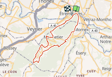
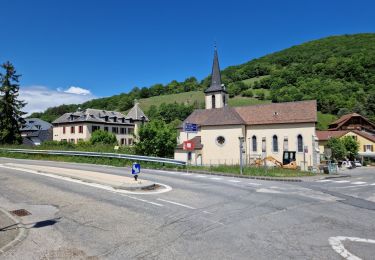
Randonnée Marche de 16,1 km à découvrir à Auvergne-Rhône-Alpes, Haute-Savoie, Étrembières. Cette randonnée est proposée par Kargil.
Description
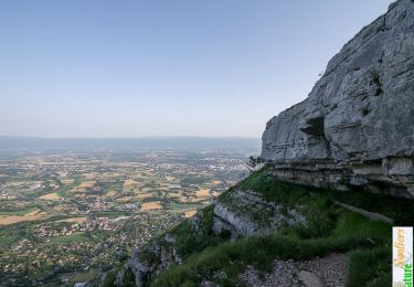
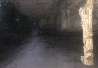
Ne pas s'engager sous les Voûtes si sensibilité au vertige.
Attention certains passages interdisent toutes chutes ou glissades.
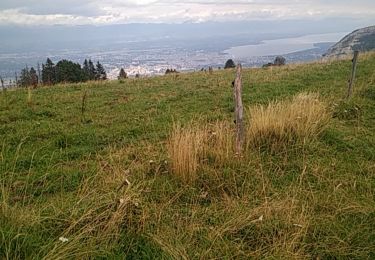
Présence sonore importante due à la proximité de l'autoroute en contrebas.
La beauté du site rend sourd et l'on fini par oublier le bruit.
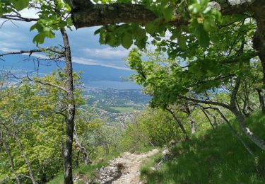
Présence de belles voies d'escalade avant de sortir des Voûtes.
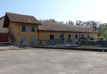
Retour par le chemin du Funiculaire pour un peu d'histoire et de nostalgie.
Localisation
Commentaires
Randonnées à proximité
![Randonnée Marche Monnetier-Mornex - Salève, circuit par la vire de la Corraterie - Photo](https://media.geolcdn.com/t/375/260/ext.jpg?maxdim=2&url=https%3A%2F%2Fservices.sitytrail.com%2FGeolivesWS%2FDownloadMedia.ashx%3FTrailID%3D172408%26Media%3D13754_1.jpg)
![Marche Marche](https://static1.geolcdn.com/sitytour/trail-icons/101.png)
Marche
![](/images/other/stat-length.png)
![](https://static1.geolcdn.com/siteimages/upload/files/16400158638029165_repeat_loop_refresh_sync_direction_icon.png)
![Randonnée A pied Veyrier - Eaux d'Arve - Pinchat - Photo](https://media.geolcdn.com/t/375/260/01df3976-cbc6-4733-8377-6a29e56e0add.jpeg&format=jpg&maxdim=2)
![A pied A pied](https://static1.geolcdn.com/sitytour/trail-icons/100.png)
A pied
![](/images/other/stat-length.png)
![](https://static1.geolcdn.com/siteimages/upload/files/16400158638029165_repeat_loop_refresh_sync_direction_icon.png)
![Randonnée A pied Thônex - Pont Bochet - Sierne Veyrier - Photo](https://media.geolcdn.com/t/375/260/953bf812-f492-4f60-8e7a-6234796e86dc.jpeg&format=jpg&maxdim=2)
![A pied A pied](https://static1.geolcdn.com/sitytour/trail-icons/100.png)
A pied
![](/images/other/stat-length.png)
![](https://static1.geolcdn.com/siteimages/upload/files/16400158638029165_repeat_loop_refresh_sync_direction_icon.png)
![Randonnée Marche Monnetier-Mornex - sentier de la Sauge - Photo](https://media.geolcdn.com/t/375/260/c35518be-b219-456a-b639-b0d81d9789ec.jpg&format=jpg&maxdim=2)
![Marche Marche](https://static1.geolcdn.com/sitytour/trail-icons/101.png)
Marche
![](/images/other/stat-length.png)
![](https://static1.geolcdn.com/siteimages/upload/files/16400158638029165_repeat_loop_refresh_sync_direction_icon.png)
![Randonnée V.T.T. Reignier-Ésery - les Bornes 11 aout 31km - Photo](https://media.geolcdn.com/t/375/260/ext.jpg?maxdim=2&url=https%3A%2F%2Fstatic1.geolcdn.com%2Fsiteimages%2Fupload%2Ffiles%2F1524743154velo.jpg)
![V.T.T. V.T.T.](https://static1.geolcdn.com/sitytour/trail-icons/202.png)
V.T.T.
![](/images/other/stat-length.png)
![](https://static1.geolcdn.com/siteimages/upload/files/16400158638029165_repeat_loop_refresh_sync_direction_icon.png)
![Randonnée V.T.T. Monnetier-Mornex - ETREMBIERES BALCON DE L ARVE - Photo](https://media.geolcdn.com/t/375/260/fb741536-4943-4b50-9fef-4bee09b8e01c.jpeg&format=jpg&maxdim=2)
![V.T.T. V.T.T.](https://static1.geolcdn.com/sitytour/trail-icons/202.png)
V.T.T.
![](/images/other/stat-length.png)
![](https://static1.geolcdn.com/siteimages/upload/files/16400158638029165_repeat_loop_refresh_sync_direction_icon.png)
![Randonnée V.T.T. Étrembières - ETREMBIERES LE SALEVE LE SAPPEY LA CROISETTE - Photo](https://media.geolcdn.com/t/375/260/df0ac700-1377-4355-a9d7-99b658d08b63.jpg&format=jpg&maxdim=2)
![V.T.T. V.T.T.](https://static1.geolcdn.com/sitytour/trail-icons/202.png)
V.T.T.
![](/images/other/stat-length.png)
![](https://static1.geolcdn.com/siteimages/upload/files/16400158638029165_repeat_loop_refresh_sync_direction_icon.png)
![Randonnée Marche Collonges-sous-Salève - Mont Salève, la grande gorge - Photo](https://media.geolcdn.com/t/375/260/f4a5a286-7b57-48d1-a03e-6798f01f2c77.jpg&format=jpg&maxdim=2)
![Marche Marche](https://static1.geolcdn.com/sitytour/trail-icons/101.png)
Marche
![](/images/other/stat-length.png)
![](https://static1.geolcdn.com/siteimages/upload/files/16400158638029165_repeat_loop_refresh_sync_direction_icon.png)
![Randonnée Marche Étrembières - D'Etrembieres au Téléphérique du Salève - Photo](https://media.geolcdn.com/t/375/260/ext.jpg?maxdim=2&url=https%3A%2F%2Fservices.sitytrail.com%2FGeolivesWS%2FDownloadMedia.ashx%3FTrailID%3D820511%26Media%3D20170830202136.jpg)
![Marche Marche](https://static1.geolcdn.com/sitytour/trail-icons/101.png)
Marche
![](/images/other/stat-length.png)
![](https://static1.geolcdn.com/siteimages/upload/files/16400158638029165_repeat_loop_refresh_sync_direction_icon.png)