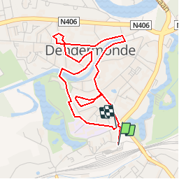
![](/images/other/stat-length.png)
![Randonnée Marche Termonde - Dendermonde stadswandeling nabij de Dender - Photo](https://media.geolcdn.com/t/1900/400/ext.pjpeg?maxdim=2&url=https%3A%2F%2Fstatic1.geolcdn.com%2Fsiteimages%2Fupload%2Ffiles%2F1553511878bg_sport_marche.png)
Dendermonde stadswandeling nabij de Dender
zorro
Utilisateur
![Longueur](/images/other/stat-length.png)
![Altitude max](https://static1.geolcdn.com/siteimages/upload/files/1508320355ic_sort_altitude_max_24dp.png)
![Dénivelé positif](https://static1.geolcdn.com/siteimages/upload/files/1508320355ic_sort_den_pos_24dp.png)
![Km-Effort](/images/other/stat-length.png)
![Altitude min](https://static1.geolcdn.com/siteimages/upload/files/1508320355ic_sort_altitude_min_24dp.png)
![Dénivelé négatif](https://static1.geolcdn.com/siteimages/upload/files/1508320355ic_sort_den_neg_24dp.png)
![Boucle](https://static1.geolcdn.com/siteimages/upload/files/16400158638029165_repeat_loop_refresh_sync_direction_icon.png)
![Marche](https://static1.geolcdn.com/sitytour/trail-icons/101.png)
1h00
Difficulté : Moyen
![Scannez ce code QR pour ouvrir la randonnée dans l'application SityTrail](https://capi.geolives.com/qq0zvz2zws4bq2lad0pu/sitytour/trails/250831/qr.png?size=200)
Application GPS de randonnée GRATUITE
À propos
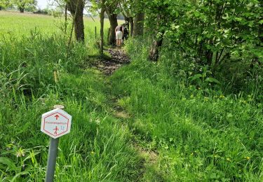
Randonnée Marche de 4,2 km à découvrir à Flandre, Flandre orientale, Termonde. Cette randonnée est proposée par zorro.
Description
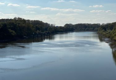
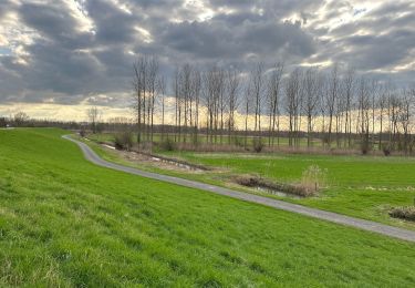
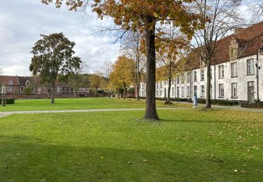
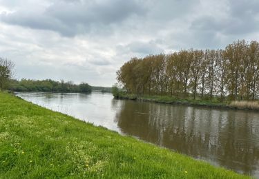
De samenvloeiing van Schelde en Dender leek de verre voorouders allicht een geschikte locatie om een nederzetting te stichten. Vandaag heeft de Dender (en de Oude Dender) nog steeds een centrale plaats in het hart van de stad. Onderweg ontmoeten we de rivier zowel in een natuurlijke als in een meer stedelijke omgeving. Dendermonde eert zijn helden, zoveel is duidelijk onderweg: we ontmoeten onder meer het Ros Beiaard en de Grote Zwartrok.
Localisation
Commentaires
Randonnées à proximité
![Randonnée A pied Alost - Vossewegel - Photo](https://media.geolcdn.com/t/375/260/790266d6-c757-441e-a4a8-3a2681fe97be.jpeg&format=jpg&maxdim=2)
![A pied A pied](https://static1.geolcdn.com/sitytour/trail-icons/100.png)
A pied
![](/images/other/stat-length.png)
![](https://static1.geolcdn.com/siteimages/upload/files/16400158638029165_repeat_loop_refresh_sync_direction_icon.png)
![Randonnée A pied Zele - Scheldemeersenpad - Photo](https://media.geolcdn.com/t/375/260/fbe7db51-af25-40aa-a60c-86b309dacd4b.jpeg&format=jpg&maxdim=2)
![A pied A pied](https://static1.geolcdn.com/sitytour/trail-icons/100.png)
A pied
![](/images/other/stat-length.png)
![](https://static1.geolcdn.com/siteimages/upload/files/16400158638029165_repeat_loop_refresh_sync_direction_icon.png)
![Randonnée A pied Lebbeke - Rondom Belle - Photo](https://media.geolcdn.com/t/375/260/1bd45d74-f7a9-408b-b213-f19979941bb6.jpeg&format=jpg&maxdim=2)
![A pied A pied](https://static1.geolcdn.com/sitytour/trail-icons/100.png)
A pied
![](/images/other/stat-length.png)
![](https://static1.geolcdn.com/siteimages/upload/files/16400158638029165_repeat_loop_refresh_sync_direction_icon.png)
![Randonnée A pied Lebbeke - Mennenpad - Photo](https://media.geolcdn.com/t/375/260/9ca09073-979e-439c-9e92-d1334cfb6bb5.jpeg&format=jpg&maxdim=2)
![A pied A pied](https://static1.geolcdn.com/sitytour/trail-icons/100.png)
A pied
![](/images/other/stat-length.png)
![](https://static1.geolcdn.com/siteimages/upload/files/16400158638029165_repeat_loop_refresh_sync_direction_icon.png)
![Randonnée Marche Termonde - Dendermonde Kastel 17,8 km - Photo](https://media.geolcdn.com/t/375/260/5ab66c0e-054a-48f1-ae4b-2ec0036e1db9.jpg&format=jpg&maxdim=2)
![Marche Marche](https://static1.geolcdn.com/sitytour/trail-icons/101.png)
Marche
![](/images/other/stat-length.png)
![](https://static1.geolcdn.com/siteimages/upload/files/16400158638029165_repeat_loop_refresh_sync_direction_icon.png)
![Randonnée Marche Lebbeke - Wieze Vossewegelroute - Photo](https://media.geolcdn.com/t/375/260/4cbd18b9-62c2-4f01-919a-e46986a49074.jpg&format=jpg&maxdim=2)
![Marche Marche](https://static1.geolcdn.com/sitytour/trail-icons/101.png)
Marche
![](/images/other/stat-length.png)
![](https://static1.geolcdn.com/siteimages/upload/files/16400158638029165_repeat_loop_refresh_sync_direction_icon.png)
![Randonnée Marche Termonde - Dendermonde Moerzeke 19,5 km - Photo](https://media.geolcdn.com/t/375/260/3a9ee0db-af98-4d38-a619-86d4471bfcdf.jpg&format=jpg&maxdim=2)
![Marche Marche](https://static1.geolcdn.com/sitytour/trail-icons/101.png)
Marche
![](/images/other/stat-length.png)
![](https://static1.geolcdn.com/siteimages/upload/files/16400158638029165_repeat_loop_refresh_sync_direction_icon.png)
![Randonnée Marche Termonde - Dendermonde 18,4 km - Photo](https://media.geolcdn.com/t/375/260/3ce27867-45e6-4e9a-a59f-7c9b466ef5ca.jpg&format=jpg&maxdim=2)
![Marche Marche](https://static1.geolcdn.com/sitytour/trail-icons/101.png)
Marche
![](/images/other/stat-length.png)
![](https://static1.geolcdn.com/siteimages/upload/files/16400158638029165_repeat_loop_refresh_sync_direction_icon.png)
![Randonnée Marche Hamme - Kastel 15,5 km - Photo](https://media.geolcdn.com/t/375/260/ed45e82f-d5d6-4538-a4b3-b0742203189b.jpg&format=jpg&maxdim=2)
![Marche Marche](https://static1.geolcdn.com/sitytour/trail-icons/101.png)
Marche
![](/images/other/stat-length.png)
![](https://static1.geolcdn.com/siteimages/upload/files/16400158638029165_repeat_loop_refresh_sync_direction_icon.png)