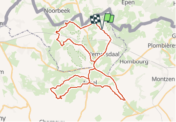
![](/images/other/stat-length.png)
![Randonnée Vélo Fourons - Fietsroute in Voeren en Herve - Photo](https://media.geolcdn.com/t/1900/400/ext.pjpeg?maxdim=2&url=https%3A%2F%2Fstatic1.geolcdn.com%2Fsiteimages%2Fupload%2Ffiles%2F1524743154velo.jpg)
Fietsroute in Voeren en Herve
zorro
Utilisateur
![Longueur](/images/other/stat-length.png)
![Altitude max](https://static1.geolcdn.com/siteimages/upload/files/1508320355ic_sort_altitude_max_24dp.png)
![Dénivelé positif](https://static1.geolcdn.com/siteimages/upload/files/1508320355ic_sort_den_pos_24dp.png)
![Km-Effort](/images/other/stat-length.png)
![Altitude min](https://static1.geolcdn.com/siteimages/upload/files/1508320355ic_sort_altitude_min_24dp.png)
![Dénivelé négatif](https://static1.geolcdn.com/siteimages/upload/files/1508320355ic_sort_den_neg_24dp.png)
![Boucle](https://static1.geolcdn.com/siteimages/upload/files/16400158638029165_repeat_loop_refresh_sync_direction_icon.png)
![Vélo](https://static1.geolcdn.com/sitytour/trail-icons/200.png)
2h43
Difficulté : Moyen
![Scannez ce code QR pour ouvrir la randonnée dans l'application SityTrail](https://capi.geolives.com/qq0zvz2zws4bq2lad0pu/sitytour/trails/250802/qr.png?size=200)
Application GPS de randonnée GRATUITE
À propos
Randonnée Vélo de 40 km à découvrir à Flandre, Limbourg, Fourons. Cette randonnée est proposée par zorro.
Description
We brengen je met deze fietsroute door twee verschillende landschappen: Voeren en Herve. Zowat om de 5 km krijg je een totaal ander en wondermooi panorama te zien. Je komt langs St-Martens-Voeren. Je kan een bezoek brengen aan de landcommanderij in St-Pieters-Voeren met een verrassend kasteel en forellenkwekerij. Daarna is het fietsen naar het Amerikaans kerkhof van Henri-Chapelle met een uniek uitzicht. Om via Aubel (elke zondagvoormiddag een bijzondere markt) in de abdij van Val-Dieu te belanden. Dan gaat het terug naar Teuven en De Planck, de startplaats met haar karaktervolle en charmante taverne's.
Localisation
Commentaires
Randonnées à proximité
![Randonnée Marche Plombières - Hombourg. Natura 2000, des sites qui valent le détour ! Lg6 - Photo](https://media.geolcdn.com/t/375/260/ext.jpg?maxdim=2&url=https%3A%2F%2Fservices.sitytrail.com%2FGeolivesWS%2FDownloadMedia.ashx%3FTrailID%3D142693%26Media%3D08dbd372-9409-44af-92fd-51b9576d1e78.JPG)
![Marche Marche](https://static1.geolcdn.com/sitytour/trail-icons/101.png)
Marche
![](/images/other/stat-length.png)
![](https://static1.geolcdn.com/siteimages/upload/files/16400158638029165_repeat_loop_refresh_sync_direction_icon.png)
![Randonnée Marche Gulpen-Wittem - Epen _1518 - Photo](https://media.geolcdn.com/t/375/260/8521698d-6278-4db9-b85e-3d349e5101aa.jpg&format=jpg&maxdim=2)
![Marche Marche](https://static1.geolcdn.com/sitytour/trail-icons/101.png)
Marche
![](/images/other/stat-length.png)
![](https://static1.geolcdn.com/siteimages/upload/files/16400158638029165_repeat_loop_refresh_sync_direction_icon.png)
![Randonnée Marche Fourons - Amstel Gold Race 2024 🚲 - Photo](https://media.geolcdn.com/t/375/260/bca146f7-0c03-4970-a3ca-ea328283e994.jpg&format=jpg&maxdim=2)
![Marche Marche](https://static1.geolcdn.com/sitytour/trail-icons/101.png)
Marche
![](/images/other/stat-length.png)
![](https://static1.geolcdn.com/siteimages/upload/files/16400158638029165_repeat_loop_refresh_sync_direction_icon.png)
![Randonnée Marche Gulpen-Wittem - Epen - Vijlen - Mechelen - Photo](https://media.geolcdn.com/t/375/260/5bb62a81-94e0-4aeb-8671-819fde7ee6b3.jpg&format=jpg&maxdim=2)
![Marche Marche](https://static1.geolcdn.com/sitytour/trail-icons/101.png)
Marche
![](/images/other/stat-length.png)
![](https://static1.geolcdn.com/siteimages/upload/files/16400158638029165_repeat_loop_refresh_sync_direction_icon.png)
![Randonnée Marche Fourons - Ulvend - La Planck - Noorbeek - Photo](https://media.geolcdn.com/t/375/260/1b8a3af4-c436-4943-b8e2-3197209c6144.jpg&format=jpg&maxdim=2)
![Marche Marche](https://static1.geolcdn.com/sitytour/trail-icons/101.png)
Marche
![](/images/other/stat-length.png)
![](https://static1.geolcdn.com/siteimages/upload/files/16400158638029165_repeat_loop_refresh_sync_direction_icon.png)
![Randonnée Marche Fourons - Wandelroute-de-voerstreek-mooiste - Photo](https://media.geolcdn.com/t/375/260/3df743f8-88e4-4c10-a47a-c05fdf0072fe.jpg&format=jpg&maxdim=2)
![Marche Marche](https://static1.geolcdn.com/sitytour/trail-icons/101.png)
Marche
![](/images/other/stat-length.png)
![](https://static1.geolcdn.com/siteimages/upload/files/16400158638029165_repeat_loop_refresh_sync_direction_icon.png)
![Randonnée Marche Fourons - La Commanderie 7 - Photo](https://media.geolcdn.com/t/375/260/e2b67305-0779-4cca-9070-82e3402cc790.jpg&format=jpg&maxdim=2)
![Marche Marche](https://static1.geolcdn.com/sitytour/trail-icons/101.png)
Marche
![](/images/other/stat-length.png)
![](https://static1.geolcdn.com/siteimages/upload/files/16400158638029165_repeat_loop_refresh_sync_direction_icon.png)
![Randonnée Marche Gulpen-Wittem - Epen 730 - Photo](https://media.geolcdn.com/t/375/260/6d525f96-e75b-473b-8ed3-0e3441be1b34.jpg&format=jpg&maxdim=2)
![Marche Marche](https://static1.geolcdn.com/sitytour/trail-icons/101.png)
Marche
![](/images/other/stat-length.png)
![](https://static1.geolcdn.com/siteimages/upload/files/16400158638029165_repeat_loop_refresh_sync_direction_icon.png)
![Randonnée Marche Eijsden-Margraten - Banholt _031 - Photo](https://media.geolcdn.com/t/375/260/136c3226-85ca-4638-b449-da2a119d703c.jpg&format=jpg&maxdim=2)
![Marche Marche](https://static1.geolcdn.com/sitytour/trail-icons/101.png)
Marche
![](/images/other/stat-length.png)
![](https://static1.geolcdn.com/siteimages/upload/files/16400158638029165_repeat_loop_refresh_sync_direction_icon.png)