![](/images/other/stat-length.png)
![Randonnée V.T.T. Andermatt - WallisBike 12 Andermatt - Disentis - Photo](https://media.geolcdn.com/t/1900/400/ext.pjpeg?maxdim=2&url=https%3A%2F%2Fstatic1.geolcdn.com%2Fsiteimages%2Fupload%2Ffiles%2F1524743154velo.jpg)
WallisBike 12 Andermatt - Disentis
ovronne
Utilisateur
![Longueur](/images/other/stat-length.png)
Longueur
45 km
![Altitude max](https://static1.geolcdn.com/siteimages/upload/files/1508320355ic_sort_altitude_max_24dp.png)
Altitude max
2425 m
![Dénivelé positif](https://static1.geolcdn.com/siteimages/upload/files/1508320355ic_sort_den_pos_24dp.png)
Dénivelé positif
1773 m
![Km-Effort](/images/other/stat-length.png)
Km-Effort
70 km
![Altitude min](https://static1.geolcdn.com/siteimages/upload/files/1508320355ic_sort_altitude_min_24dp.png)
Altitude min
1022 m
![Dénivelé négatif](https://static1.geolcdn.com/siteimages/upload/files/1508320355ic_sort_den_neg_24dp.png)
Dénivelé négatif
2044 m
![Boucle](https://static1.geolcdn.com/siteimages/upload/files/16400158638029165_repeat_loop_refresh_sync_direction_icon.png)
Boucle
Non
Date de création :
2014-12-11 00:00:00.0
Dernière modification :
2014-12-11 00:00:00.0
![V.T.T.](https://static1.geolcdn.com/sitytour/trail-icons/202.png)
5h00
Difficulté : Inconnu
![Scannez ce code QR pour ouvrir la randonnée dans l'application SityTrail](https://capi.geolives.com/qq0zvz2zws4bq2lad0pu/sitytour/trails/25071/qr.png?size=200)
Application GPS de randonnée GRATUITE
À propos
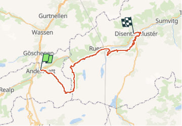
Randonnée V.T.T. de 45 km à découvrir à Uri, Korporation Ursern, Andermatt. Cette randonnée est proposée par ovronne.
Description
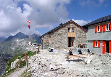
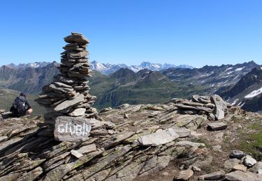
Douzième étape de la traversée des Alpes Suisse de St-Gingolph à Scuol.
Départ d''Andermatt, montée jusqu''au Pass Maighels, descente sur Tschamut puis Mompé Medel et Disentis
Localisation
Pays :
Suisse
Région :
Uri
Département/Province :
Korporation Ursern
Commune :
Andermatt
Localité :
Unknown
Départ:(Dec)
Départ:(UTM)
469045 ; 5164789 (32T) N.
Commentaires
Randonnées à proximité
![Randonnée A pied Andermatt - Kräuterlehrpfad Mur - Photo](https://media.geolcdn.com/t/375/260/23ebdf3d-6550-42a3-bdcb-791aa1e419ea.jpeg&format=jpg&maxdim=2)
![A pied A pied](https://static1.geolcdn.com/sitytour/trail-icons/100.png)
Kräuterlehrpfad Mur
A pied
Facile
Andermatt,
Uri,
Korporation Ursern,
Suisse
![](/images/other/stat-length.png)
7,6 km | 10,5 km-effort
2h 23min
![](https://static1.geolcdn.com/siteimages/upload/files/16400158638029165_repeat_loop_refresh_sync_direction_icon.png)
Non
![Randonnée A pied Andermatt - Blumen- und Lawinenlehrpfad Chilchenberg - Photo](https://media.geolcdn.com/t/375/260/23ebdf3d-6550-42a3-bdcb-791aa1e419ea.jpeg&format=jpg&maxdim=2)
![A pied A pied](https://static1.geolcdn.com/sitytour/trail-icons/100.png)
Blumen- und Lawinenlehrpfad Chilchenberg
A pied
Facile
Andermatt,
Uri,
Korporation Ursern,
Suisse
![](/images/other/stat-length.png)
3,9 km | 8,4 km-effort
1h 54min
![](https://static1.geolcdn.com/siteimages/upload/files/16400158638029165_repeat_loop_refresh_sync_direction_icon.png)
Non
![Randonnée A pied Andermatt - Schöni - Pazolalücke - Photo](https://media.geolcdn.com/t/375/260/d1617093-8655-46c4-9467-a0f549651cea.jpeg&format=jpg&maxdim=2)
![A pied A pied](https://static1.geolcdn.com/sitytour/trail-icons/100.png)
Schöni - Pazolalücke
A pied
Facile
Andermatt,
Uri,
Korporation Ursern,
Suisse
![](/images/other/stat-length.png)
3,7 km | 10,3 km-effort
2h 20min
![](https://static1.geolcdn.com/siteimages/upload/files/16400158638029165_repeat_loop_refresh_sync_direction_icon.png)
Non
![Randonnée A pied Andermatt - Stöckli - Steglaui Riental - Photo](https://media.geolcdn.com/t/375/260/18a6a89b-b2db-4bc5-bdbd-b09a3baf89d4.jpeg&format=jpg&maxdim=2)
![A pied A pied](https://static1.geolcdn.com/sitytour/trail-icons/100.png)
Stöckli - Steglaui Riental
A pied
Facile
Andermatt,
Uri,
Korporation Ursern,
Suisse
![](/images/other/stat-length.png)
6,7 km | 11,2 km-effort
2h 33min
![](https://static1.geolcdn.com/siteimages/upload/files/16400158638029165_repeat_loop_refresh_sync_direction_icon.png)
Non
![Randonnée A pied Andermatt - Golfrundweg - Photo](https://media.geolcdn.com/t/375/260/89334e40-d25e-499c-90c6-7d30e1b20946.jpeg&format=jpg&maxdim=2)
![A pied A pied](https://static1.geolcdn.com/sitytour/trail-icons/100.png)
Golfrundweg
A pied
Facile
Andermatt,
Uri,
Korporation Ursern,
Suisse
![](/images/other/stat-length.png)
5,6 km | 7,2 km-effort
1h 38min
![](https://static1.geolcdn.com/siteimages/upload/files/16400158638029165_repeat_loop_refresh_sync_direction_icon.png)
Oui
![Randonnée A pied Andermatt - Vermigel - Capanna Cadlimo - Photo](https://media.geolcdn.com/t/375/260/55e4726d-a963-4121-9825-2227d492a520.jpeg&format=jpg&maxdim=2)
![A pied A pied](https://static1.geolcdn.com/sitytour/trail-icons/100.png)
Vermigel - Capanna Cadlimo
A pied
Facile
Andermatt,
Uri,
Korporation Ursern,
Suisse
![](/images/other/stat-length.png)
7,4 km | 17,6 km-effort
4h 0min
![](https://static1.geolcdn.com/siteimages/upload/files/16400158638029165_repeat_loop_refresh_sync_direction_icon.png)
Non
![Randonnée A pied Andermatt - Lago della Sella - Sunnsbühl - Photo](https://media.geolcdn.com/t/375/260/8dfbce18-3c5b-4b83-9802-71ce5e04d009.jpeg&format=jpg&maxdim=2)
![A pied A pied](https://static1.geolcdn.com/sitytour/trail-icons/100.png)
Lago della Sella - Sunnsbühl
A pied
Facile
Andermatt,
Uri,
Korporation Ursern,
Suisse
![](/images/other/stat-length.png)
5 km | 12,4 km-effort
2h 48min
![](https://static1.geolcdn.com/siteimages/upload/files/16400158638029165_repeat_loop_refresh_sync_direction_icon.png)
Non
![Randonnée A pied Andermatt - Ursener Höhenweg - Photo](https://media.geolcdn.com/t/375/260/f7b36a6e-ed2a-4f4f-9e56-9c6f30267693.jpeg&format=jpg&maxdim=2)
![A pied A pied](https://static1.geolcdn.com/sitytour/trail-icons/100.png)
Ursener Höhenweg
A pied
Moyen
Andermatt,
Uri,
Korporation Ursern,
Suisse
![](/images/other/stat-length.png)
13,9 km | 26 km-effort
5h 49min
![](https://static1.geolcdn.com/siteimages/upload/files/16400158638029165_repeat_loop_refresh_sync_direction_icon.png)
Non
![Randonnée A pied Andermatt - Andermatt - Vermigel - Photo](https://media.geolcdn.com/t/375/260/ext.jpg?maxdim=2&url=https%3A%2F%2Fstatic1.geolcdn.com%2Fsiteimages%2Fupload%2Ffiles%2F1545311037marcheuse_200dpi.jpg)
![A pied A pied](https://static1.geolcdn.com/sitytour/trail-icons/100.png)
Andermatt - Vermigel
A pied
Facile
Andermatt,
Uri,
Korporation Ursern,
Suisse
![](/images/other/stat-length.png)
5,5 km | 10,1 km-effort
2h 17min
![](https://static1.geolcdn.com/siteimages/upload/files/16400158638029165_repeat_loop_refresh_sync_direction_icon.png)
Non