![](/images/other/stat-length.png)
Pic d'anie depuis la station de la pierre st martin : boucle
mbo8131
Utilisateur
![Longueur](/images/other/stat-length.png)
![Altitude max](https://static1.geolcdn.com/siteimages/upload/files/1508320355ic_sort_altitude_max_24dp.png)
![Dénivelé positif](https://static1.geolcdn.com/siteimages/upload/files/1508320355ic_sort_den_pos_24dp.png)
![Km-Effort](/images/other/stat-length.png)
![Altitude min](https://static1.geolcdn.com/siteimages/upload/files/1508320355ic_sort_altitude_min_24dp.png)
![Dénivelé négatif](https://static1.geolcdn.com/siteimages/upload/files/1508320355ic_sort_den_neg_24dp.png)
![Boucle](https://static1.geolcdn.com/siteimages/upload/files/16400158638029165_repeat_loop_refresh_sync_direction_icon.png)
![Marche](https://static1.geolcdn.com/sitytour/trail-icons/101.png)
8h00
Difficulté : Difficile
![Scannez ce code QR pour ouvrir la randonnée dans l'application SityTrail](https://capi.geolives.com/qq0zvz2zws4bq2lad0pu/sitytour/trails/2503879/qr.png?size=200)
Application GPS de randonnée GRATUITE
À propos
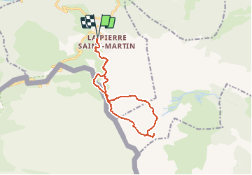
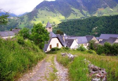
Randonnée Marche de 15,6 km à découvrir à Nouvelle-Aquitaine, Pyrénées-Atlantiques, Arette. Cette randonnée est proposée par mbo8131.
Description
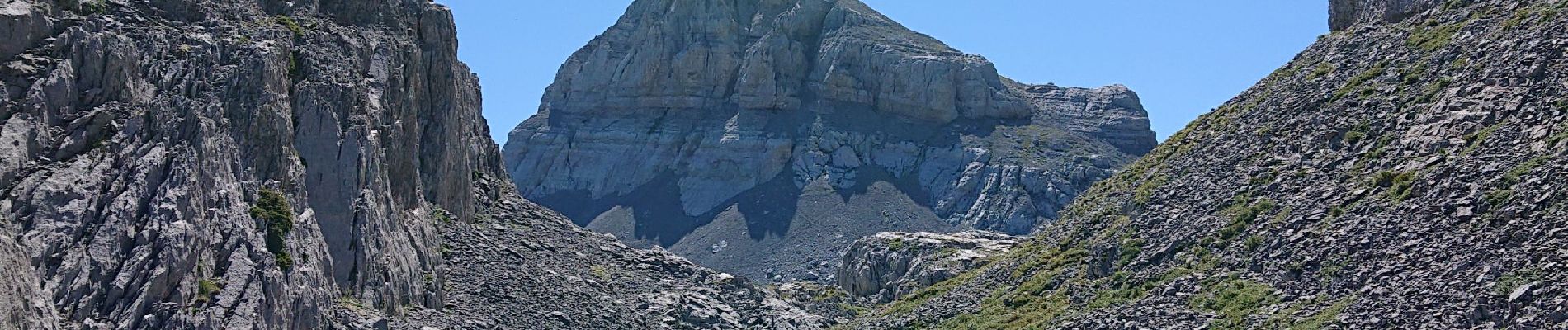
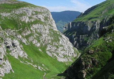
Randonnée très particulière , réservée aux personnes en bonne forme physique.
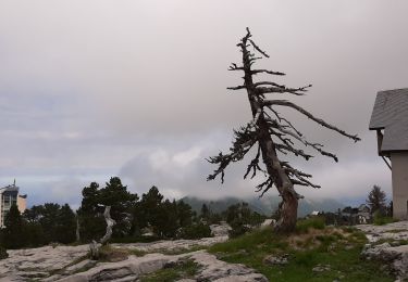
Il n'y a pas un seul arbre sur la totalité du parcours. Univers entièrement minéral.
Il faut souvent s'aider des mains pour franchir les passages rocheux, qui rendent la progression compliquée, surtout dans la première partie.
Prévoir les équipements suivants :
- 2 litres d'eau minimum.
- Chaussures montantes ( on marche sur de la roche ) avec une bonne accroche.
- Bâtons
- Casquette/chapeau , lunettes de soleil ( le calcaire renvoie la lumière ), crème solaire.
Une variante, à mon avis plus intéressante , serait de partir du col de la Pierre St Martin, pour éviter l'ascension depuis la station au milieu des remontées mécaniques, qui ne présente pas d'intérêt.
Localisation
Commentaires
Randonnées à proximité
![Randonnée A pied Lanne-en-Barétous - ISSARBE les crêtes 2893126 - Photo](https://media.geolcdn.com/t/375/260/755218ac-9ef4-4c72-9363-0dc6b489c5da.jpg&format=jpg&maxdim=2)
![A pied A pied](https://static1.geolcdn.com/sitytour/trail-icons/100.png)
A pied
![](/images/other/stat-length.png)
![](https://static1.geolcdn.com/siteimages/upload/files/16400158638029165_repeat_loop_refresh_sync_direction_icon.png)
![Randonnée A pied Osse-en-Aspe - LOURDIOS ICHERE chemin de la mâture d issaux G3 le 11/09/2020 (fait) - Photo](https://media.geolcdn.com/t/375/260/5b0c411e-8081-4f6e-b925-8fd4863ce198.jpg&format=jpg&maxdim=2)
![A pied A pied](https://static1.geolcdn.com/sitytour/trail-icons/100.png)
A pied
![](/images/other/stat-length.png)
![](https://static1.geolcdn.com/siteimages/upload/files/16400158638029165_repeat_loop_refresh_sync_direction_icon.png)
![Randonnée Marche Arette - GR 10 - 12ème etape - Arette -La Pierre-st-Matin - Le refuge de l’Abérouat - Lescun - Photo](https://media.geolcdn.com/t/375/260/ef455401-c2e2-4a88-bda3-f460b6d8e990.jpg&format=jpg&maxdim=2)
![Marche Marche](https://static1.geolcdn.com/sitytour/trail-icons/101.png)
Marche
![](/images/other/stat-length.png)
![](https://static1.geolcdn.com/siteimages/upload/files/16400158638029165_repeat_loop_refresh_sync_direction_icon.png)
![Randonnée Marche Arette - Col de Pescamou Arette La pierre St. Martin - Photo](https://media.geolcdn.com/t/375/260/310d2d8c-1f1e-4c49-9bd5-a017f557061c.jpg&format=jpg&maxdim=2)
![Marche Marche](https://static1.geolcdn.com/sitytour/trail-icons/101.png)
Marche
![](/images/other/stat-length.png)
![](https://static1.geolcdn.com/siteimages/upload/files/16400158638029165_repeat_loop_refresh_sync_direction_icon.png)
![Randonnée Autre activité Sainte-Engrâce - TDP N°9 STE EN GRÂCE ARÊTE LA PIERRE ST MARTIN - Photo](https://media.geolcdn.com/t/375/260/ext.jpg?maxdim=2&url=https%3A%2F%2Fservices.sitytrail.com%2FGeolivesWS%2FDownloadMedia.ashx%3FTrailID%3D751606%26Media%3Dfix__20170511123156.jpg)
![Autre activité Autre activité](https://static1.geolcdn.com/sitytour/trail-icons/900.png)
Autre activité
![](/images/other/stat-length.png)
![](https://static1.geolcdn.com/siteimages/upload/files/16400158638029165_repeat_loop_refresh_sync_direction_icon.png)
![Randonnée Marche Arette - La Pierre St Martin à Lescun - Photo](https://media.geolcdn.com/t/375/260/ext.jpg?maxdim=2&url=https%3A%2F%2Fservices.sitytrail.com%2FGeolivesWS%2FDownloadMedia.ashx%3FTrailID%3D109452%26Media%3D3904_4.jpg)
![Marche Marche](https://static1.geolcdn.com/sitytour/trail-icons/101.png)
Marche
![](/images/other/stat-length.png)
![](https://static1.geolcdn.com/siteimages/upload/files/16400158638029165_repeat_loop_refresh_sync_direction_icon.png)
![Randonnée Marche Sainte-Engrâce - st-engrace-Gorges-D'Ehujarre - Photo](https://media.geolcdn.com/t/375/260/f128e555-5abd-40fc-a180-29140085bec2.jpg&format=jpg&maxdim=2)
![Marche Marche](https://static1.geolcdn.com/sitytour/trail-icons/101.png)
Marche
![](/images/other/stat-length.png)
![](https://static1.geolcdn.com/siteimages/upload/files/16400158638029165_repeat_loop_refresh_sync_direction_icon.png)
![Randonnée A pied Arette - LPSM](https://media.geolcdn.com/t/375/260/ext.jpg?maxdim=2&url=https%3A%2F%2Fstatic1.geolcdn.com%2Fsiteimages%2Fupload%2Ffiles%2F1545311037marcheuse_200dpi.jpg)
![A pied A pied](https://static1.geolcdn.com/sitytour/trail-icons/100.png)
A pied
![](/images/other/stat-length.png)
![](https://static1.geolcdn.com/siteimages/upload/files/16400158638029165_repeat_loop_refresh_sync_direction_icon.png)
![Randonnée Marche Sainte-Engrâce - Le Canyon d'Ehujarre depuis Sainte-Engrâce - Photo](https://media.geolcdn.com/t/375/260/ext.jpg?maxdim=2&url=https%3A%2F%2Fservices.sitytrail.com%2FGeolivesWS%2FDownloadMedia.ashx%3FTrailID%3D110013%26Media%3D5115_1.jpg)
![Marche Marche](https://static1.geolcdn.com/sitytour/trail-icons/101.png)
Marche
![](/images/other/stat-length.png)
![](https://static1.geolcdn.com/siteimages/upload/files/16400158638029165_repeat_loop_refresh_sync_direction_icon.png)