![](/images/other/stat-length.png)
![Randonnée Autre activité Crémines - Crémines - patinoire de Moutier - Photo](https://media.geolcdn.com/t/1900/400/ext.pjpeg?maxdim=2&url=https%3A%2F%2Fstatic1.geolcdn.com%2Fsiteimages%2Fupload%2Ffiles%2F1545311037marcheuse_200dpi.jpg)
Crémines - patinoire de Moutier
rebetez
Utilisateur
![Longueur](/images/other/stat-length.png)
Longueur
10,9 km
![Altitude max](https://static1.geolcdn.com/siteimages/upload/files/1508320355ic_sort_altitude_max_24dp.png)
Altitude max
1011 m
![Dénivelé positif](https://static1.geolcdn.com/siteimages/upload/files/1508320355ic_sort_den_pos_24dp.png)
Dénivelé positif
479 m
![Km-Effort](/images/other/stat-length.png)
Km-Effort
17,5 km
![Altitude min](https://static1.geolcdn.com/siteimages/upload/files/1508320355ic_sort_altitude_min_24dp.png)
Altitude min
571 m
![Dénivelé négatif](https://static1.geolcdn.com/siteimages/upload/files/1508320355ic_sort_den_neg_24dp.png)
Dénivelé négatif
534 m
![Boucle](https://static1.geolcdn.com/siteimages/upload/files/16400158638029165_repeat_loop_refresh_sync_direction_icon.png)
Boucle
Non
Date de création :
2014-12-11 00:00:00.0
Dernière modification :
2014-12-11 00:00:00.0
![Autre activité](https://static1.geolcdn.com/sitytour/trail-icons/900.png)
--
Difficulté : Inconnu
![Scannez ce code QR pour ouvrir la randonnée dans l'application SityTrail](https://capi.geolives.com/qq0zvz2zws4bq2lad0pu/sitytour/trails/25033/qr.png?size=200)
Application GPS de randonnée GRATUITE
À propos
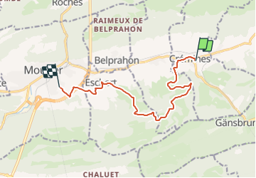
Randonnée Autre activité de 10,9 km à découvrir à Berne, Arrondissement administratif du Jura bernois, Crémines. Cette randonnée est proposée par rebetez.
Description
Crémines - charrière de Crémines - chemin des sabotiers - descente par la charrière de Grandval
Localisation
Pays :
Suisse
Région :
Berne
Département/Province :
Arrondissement administratif du Jura bernois
Commune :
Crémines
Localité :
Unknown
Départ:(Dec)
Départ:(UTM)
382336 ; 5237735 (32T) N.
Commentaires
Randonnées à proximité
![Randonnée A pied Val Terbi - Raimeux sommet - fixme - Photo](https://media.geolcdn.com/t/375/260/358c94bf-de90-42cd-b83f-c10bc4993782.jpeg&format=jpg&maxdim=2)
![A pied A pied](https://static1.geolcdn.com/sitytour/trail-icons/100.png)
Raimeux sommet - fixme
A pied
Facile
Val Terbi,
Jura,
District de Delémont,
Suisse
![](/images/other/stat-length.png)
9,1 km | 15,3 km-effort
3h 29min
![](https://static1.geolcdn.com/siteimages/upload/files/16400158638029165_repeat_loop_refresh_sync_direction_icon.png)
Non
![Randonnée A pied Val Terbi - CH-451 - Photo](https://media.geolcdn.com/t/375/260/3d152a17-cc6e-41a1-983e-298f99af708e.jpeg&format=jpg&maxdim=2)
![A pied A pied](https://static1.geolcdn.com/sitytour/trail-icons/100.png)
CH-451
A pied
Facile
Val Terbi,
Jura,
District de Delémont,
Suisse
![](/images/other/stat-length.png)
4,1 km | 6,6 km-effort
1h 29min
![](https://static1.geolcdn.com/siteimages/upload/files/16400158638029165_repeat_loop_refresh_sync_direction_icon.png)
Non
![Randonnée A pied Moutier - Chemin de Graitery - Photo](https://media.geolcdn.com/t/375/260/dev_56af3b5f-70bb-4a1b-afea-201d5c9e1231.jpeg&format=jpg&maxdim=2)
![A pied A pied](https://static1.geolcdn.com/sitytour/trail-icons/100.png)
Chemin de Graitery
A pied
Facile
Moutier,
Berne,
Arrondissement administratif du Jura bernois,
Suisse
![](/images/other/stat-length.png)
5,1 km | 8 km-effort
1h 49min
![](https://static1.geolcdn.com/siteimages/upload/files/16400158638029165_repeat_loop_refresh_sync_direction_icon.png)
Non
![Randonnée A pied Oberdorf (SO) - Planetenweg - Photo](https://media.geolcdn.com/t/375/260/dev_e05df50a-bd36-425e-a13c-8f85e627801b.jpeg&format=jpg&maxdim=2)
![A pied A pied](https://static1.geolcdn.com/sitytour/trail-icons/100.png)
Planetenweg
A pied
Facile
Oberdorf (SO),
Soleure,
Bezirk Lebern,
Suisse
![](/images/other/stat-length.png)
9,9 km | 15,2 km-effort
3h 27min
![](https://static1.geolcdn.com/siteimages/upload/files/16400158638029165_repeat_loop_refresh_sync_direction_icon.png)
Non
![Randonnée A pied Grandval - Raimeux sommet - fixme - Photo](https://media.geolcdn.com/t/375/260/ext.jpg?maxdim=2&url=https%3A%2F%2Fstatic1.geolcdn.com%2Fsiteimages%2Fupload%2Ffiles%2F1545311037marcheuse_200dpi.jpg)
![A pied A pied](https://static1.geolcdn.com/sitytour/trail-icons/100.png)
Raimeux sommet - fixme
A pied
Facile
Grandval,
Berne,
Arrondissement administratif du Jura bernois,
Suisse
![](/images/other/stat-length.png)
3,7 km | 5,3 km-effort
1h 12min
![](https://static1.geolcdn.com/siteimages/upload/files/16400158638029165_repeat_loop_refresh_sync_direction_icon.png)
Non
![Randonnée A pied Corcelles (BE) - Le Petit Pré - Sur le Golat - Photo](https://media.geolcdn.com/t/375/260/ext.jpg?maxdim=2&url=https%3A%2F%2Fstatic1.geolcdn.com%2Fsiteimages%2Fupload%2Ffiles%2F1545311037marcheuse_200dpi.jpg)
![A pied A pied](https://static1.geolcdn.com/sitytour/trail-icons/100.png)
Le Petit Pré - Sur le Golat
A pied
Facile
Corcelles (BE),
Berne,
Arrondissement administratif du Jura bernois,
Suisse
![](/images/other/stat-length.png)
3,4 km | 5 km-effort
1h 8min
![](https://static1.geolcdn.com/siteimages/upload/files/16400158638029165_repeat_loop_refresh_sync_direction_icon.png)
Non
![Randonnée A pied Val Terbi - Envelier - fixme - Photo](https://media.geolcdn.com/t/375/260/ext.jpg?maxdim=2&url=https%3A%2F%2Fstatic1.geolcdn.com%2Fsiteimages%2Fupload%2Ffiles%2F1545311037marcheuse_200dpi.jpg)
![A pied A pied](https://static1.geolcdn.com/sitytour/trail-icons/100.png)
Envelier - fixme
A pied
Facile
Val Terbi,
Jura,
District de Delémont,
Suisse
![](/images/other/stat-length.png)
3,8 km | 7,6 km-effort
1h 43min
![](https://static1.geolcdn.com/siteimages/upload/files/16400158638029165_repeat_loop_refresh_sync_direction_icon.png)
Non
![Randonnée Marche Welschenrohr-Gänsbrunnen - w09_thal1 - Photo](https://media.geolcdn.com/t/375/260/ext.jpg?maxdim=2&url=https%3A%2F%2Fstatic1.geolcdn.com%2Fsiteimages%2Fupload%2Ffiles%2F1553511878bg_sport_marche.png)
![Marche Marche](https://static1.geolcdn.com/sitytour/trail-icons/101.png)
w09_thal1
Marche
Très facile
Welschenrohr-Gänsbrunnen,
Soleure,
Bezirk Thal,
Suisse
![](/images/other/stat-length.png)
15 km | 26 km-effort
4h 35min
![](https://static1.geolcdn.com/siteimages/upload/files/16400158638029165_repeat_loop_refresh_sync_direction_icon.png)
Non
![Randonnée A pied Grandval - Grandval - Combe des Geais - Photo](https://media.geolcdn.com/t/375/260/ext.jpg?maxdim=2&url=https%3A%2F%2Fstatic1.geolcdn.com%2Fsiteimages%2Fupload%2Ffiles%2F1545311037marcheuse_200dpi.jpg)
![A pied A pied](https://static1.geolcdn.com/sitytour/trail-icons/100.png)
Grandval - Combe des Geais
A pied
Facile
Grandval,
Berne,
Arrondissement administratif du Jura bernois,
Suisse
![](/images/other/stat-length.png)
3,1 km | 4,6 km-effort
1h 2min
![](https://static1.geolcdn.com/siteimages/upload/files/16400158638029165_repeat_loop_refresh_sync_direction_icon.png)
Non