![](/images/other/stat-length.png)
![Randonnée Marche Fontainebleau - Fontainebleau - Photo](https://media.geolcdn.com/t/1900/400/b2f4f0a0-14c6-467b-a639-5d43b5c1cf69.jpeg&format=pjpeg&maxdim=2)
Fontainebleau
Jethro Gene
Utilisateur
![Longueur](/images/other/stat-length.png)
Longueur
12,4 km
![Altitude max](https://static1.geolcdn.com/siteimages/upload/files/1508320355ic_sort_altitude_max_24dp.png)
Altitude max
132 m
![Dénivelé positif](https://static1.geolcdn.com/siteimages/upload/files/1508320355ic_sort_den_pos_24dp.png)
Dénivelé positif
244 m
![Km-Effort](/images/other/stat-length.png)
Km-Effort
15,6 km
![Altitude min](https://static1.geolcdn.com/siteimages/upload/files/1508320355ic_sort_altitude_min_24dp.png)
Altitude min
73 m
![Dénivelé négatif](https://static1.geolcdn.com/siteimages/upload/files/1508320355ic_sort_den_neg_24dp.png)
Dénivelé négatif
244 m
![Boucle](https://static1.geolcdn.com/siteimages/upload/files/16400158638029165_repeat_loop_refresh_sync_direction_icon.png)
Boucle
Oui
Date de création :
2020-08-04 07:57:52.0
Dernière modification :
2020-08-04 14:40:55.96
![Marche](https://static1.geolcdn.com/sitytour/trail-icons/101.png)
4h07
Difficulté : Moyen
![Scannez ce code QR pour ouvrir la randonnée dans l'application SityTrail](https://capi.geolives.com/qq0zvz2zws4bq2lad0pu/sitytour/trails/2501823/qr.png?size=200)
Application GPS de randonnée GRATUITE
À propos
Randonnée Marche de 12,4 km à découvrir à Île-de-France, Seine-et-Marne, Fontainebleau. Cette randonnée est proposée par Jethro Gene.
Description
4h-4h30 très jolie rando que j'avais récupérée sur Visorando - le GPS de Sitytrail a été indispensable car certains passages ne sont pas vraiment bien repérables...
Localisation
Pays :
France
Région :
Île-de-France
Département/Province :
Seine-et-Marne
Commune :
Fontainebleau
Localité :
Unknown
Départ:(Dec)
Départ:(UTM)
470285 ; 5362070 (31U) N.
Commentaires
Randonnées à proximité
![Randonnée Marche Barbizon - Sentier des peintres - Photo](https://media.geolcdn.com/t/375/260/ext.jpg?maxdim=2&url=https%3A%2F%2Fservices.sitytrail.com%2FGeolivesWS%2FDownloadMedia.ashx%3FTrailID%3D188736%26Media%3D187396bd-9ee4-4169-9310-5793d2588587.jpeg)
![Marche Marche](https://static1.geolcdn.com/sitytour/trail-icons/101.png)
Sentier des peintres
Marche
Moyen
(11)
Barbizon,
Île-de-France,
Seine-et-Marne,
France
![](/images/other/stat-length.png)
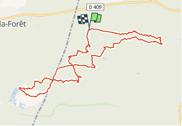
7,5 km | 8,2 km-effort
1h 25min
![](https://static1.geolcdn.com/siteimages/upload/files/16400158638029165_repeat_loop_refresh_sync_direction_icon.png)
Oui
![Randonnée Marche Fontainebleau - 3pi-150428 - DésertApremont-Jupiter - Photo](https://media.geolcdn.com/t/375/260/ext.jpg?maxdim=2&url=https%3A%2F%2Fservices.sitytrail.com%2FGeolivesWS%2FDownloadMedia.ashx%3FTrailID%3D414037%26Media%3D22942274-9308-46bb-bc6d-06c82c3e8751.jpg)
![Marche Marche](https://static1.geolcdn.com/sitytour/trail-icons/101.png)
3pi-150428 - DésertApremont-Jupiter
Marche
Facile
(1)
Fontainebleau,
Île-de-France,
Seine-et-Marne,
France
![](/images/other/stat-length.png)
16 km | 19,4 km-effort
6h 30min
![](https://static1.geolcdn.com/siteimages/upload/files/16400158638029165_repeat_loop_refresh_sync_direction_icon.png)
Oui
![Randonnée Marche Noisy-sur-École - M&R-121118 - 250Marches - Photo](https://media.geolcdn.com/t/375/260/ext.jpg?maxdim=2&url=https%3A%2F%2Fservices.sitytrail.com%2FGeolivesWS%2FDownloadMedia.ashx%3FTrailID%3D163348%26Media%3D20121118101634.jpeg)
![Marche Marche](https://static1.geolcdn.com/sitytour/trail-icons/101.png)
M&R-121118 - 250Marches
Marche
Facile
(1)
Noisy-sur-École,
Île-de-France,
Seine-et-Marne,
France
![](/images/other/stat-length.png)
14,3 km | 18,1 km-effort
3h 50min
![](https://static1.geolcdn.com/siteimages/upload/files/16400158638029165_repeat_loop_refresh_sync_direction_icon.png)
Oui
![Randonnée Marche Noisy-sur-École - Bois Rond#4 - Photo](https://media.geolcdn.com/t/375/260/7321184d-880d-445f-98b4-47f0ff0d82dd.jpg&format=jpg&maxdim=2)
![Marche Marche](https://static1.geolcdn.com/sitytour/trail-icons/101.png)
Bois Rond#4
Marche
Très facile
(1)
Noisy-sur-École,
Île-de-France,
Seine-et-Marne,
France
![](/images/other/stat-length.png)
8,8 km | 10,5 km-effort
2h 18min
![](https://static1.geolcdn.com/siteimages/upload/files/16400158638029165_repeat_loop_refresh_sync_direction_icon.png)
Oui
![Randonnée Marche Noisy-sur-École - Les 25 Bosses - Gps en Forêt de Fontainebleau - Photo](https://media.geolcdn.com/t/375/260/ext.jpg?maxdim=2&url=https%3A%2F%2Fservices.sitytrail.com%2FGeolivesWS%2FDownloadMedia.ashx%3FTrailID%3D101528%26Media%3D1630_1.jpg)
![Marche Marche](https://static1.geolcdn.com/sitytour/trail-icons/101.png)
Les 25 Bosses - Gps en Forêt de Fontainebleau
Marche
Très difficile
(2)
Noisy-sur-École,
Île-de-France,
Seine-et-Marne,
France
![](/images/other/stat-length.png)
17,6 km | 23 km-effort
4h 45min
![](https://static1.geolcdn.com/siteimages/upload/files/16400158638029165_repeat_loop_refresh_sync_direction_icon.png)
Oui
![Randonnée Marche Fontainebleau - Boucle Barbizon - Arbonne 26 km - Photo](https://media.geolcdn.com/t/375/260/d3a133ff-ea77-47a6-826a-54bbe45391c4.jpg&format=jpg&maxdim=2)
![Marche Marche](https://static1.geolcdn.com/sitytour/trail-icons/101.png)
Boucle Barbizon - Arbonne 26 km
Marche
Moyen
Fontainebleau,
Île-de-France,
Seine-et-Marne,
France
![](/images/other/stat-length.png)
26 km | 30 km-effort
5h 6min
![](https://static1.geolcdn.com/siteimages/upload/files/16400158638029165_repeat_loop_refresh_sync_direction_icon.png)
Oui
![Randonnée Marche Noisy-sur-École - Boucle 24 km Fontainebleau Arbonne - Photo](https://media.geolcdn.com/t/375/260/5aaa62f0-dc57-4770-a77a-231413885a94.jpg&format=jpg&maxdim=2)
![Marche Marche](https://static1.geolcdn.com/sitytour/trail-icons/101.png)
Boucle 24 km Fontainebleau Arbonne
Marche
Facile
Noisy-sur-École,
Île-de-France,
Seine-et-Marne,
France
![](/images/other/stat-length.png)
25 km | 31 km-effort
5h 52min
![](https://static1.geolcdn.com/siteimages/upload/files/16400158638029165_repeat_loop_refresh_sync_direction_icon.png)
Oui
![Randonnée Marche Noisy-sur-École - Noisy sur Ecole / Coquibus - Photo](https://media.geolcdn.com/t/375/260/9f6ffc55-2cbc-4988-8e49-be93fd15ba38.jpg&format=jpg&maxdim=2)
![Marche Marche](https://static1.geolcdn.com/sitytour/trail-icons/101.png)
Noisy sur Ecole / Coquibus
Marche
Moyen
Noisy-sur-École,
Île-de-France,
Seine-et-Marne,
France
![](/images/other/stat-length.png)
21 km | 26 km-effort
5h 20min
![](https://static1.geolcdn.com/siteimages/upload/files/16400158638029165_repeat_loop_refresh_sync_direction_icon.png)
Oui
![Randonnée Marche Barbizon - Le tour du Grand Paris via le GR1 etape 14 Barbizon- Malesherbes - Photo](https://media.geolcdn.com/t/375/260/8af1b7ac-6c06-4a51-9474-d487076c1a9a.jpg&format=jpg&maxdim=2)
![Marche Marche](https://static1.geolcdn.com/sitytour/trail-icons/101.png)
Le tour du Grand Paris via le GR1 etape 14 Barbizon- Malesherbes
Marche
Très difficile
Barbizon,
Île-de-France,
Seine-et-Marne,
France
![](/images/other/stat-length.png)
35 km | 41 km-effort
6h 11min
![](https://static1.geolcdn.com/siteimages/upload/files/16400158638029165_repeat_loop_refresh_sync_direction_icon.png)
Non