![](/images/other/stat-length.png)
![Randonnée Marche Revel - Pré Raymond, lac de Crozet, Refuge de la Pra, lacs Domenons, Refuge du Pré Mollard, Retour - Photo](https://media.geolcdn.com/t/1900/400/3f6e15ac-89ad-4cdf-811e-43dd8298bd03.jpg&format=pjpeg&maxdim=2)
Pré Raymond, lac de Crozet, Refuge de la Pra, lacs Domenons, Refuge du Pré Mollard, Retour
zazie
Utilisateur
![Longueur](/images/other/stat-length.png)
![Altitude max](https://static1.geolcdn.com/siteimages/upload/files/1508320355ic_sort_altitude_max_24dp.png)
![Dénivelé positif](https://static1.geolcdn.com/siteimages/upload/files/1508320355ic_sort_den_pos_24dp.png)
![Km-Effort](/images/other/stat-length.png)
![Altitude min](https://static1.geolcdn.com/siteimages/upload/files/1508320355ic_sort_altitude_min_24dp.png)
![Dénivelé négatif](https://static1.geolcdn.com/siteimages/upload/files/1508320355ic_sort_den_neg_24dp.png)
![Boucle](https://static1.geolcdn.com/siteimages/upload/files/16400158638029165_repeat_loop_refresh_sync_direction_icon.png)
![Marche](https://static1.geolcdn.com/sitytour/trail-icons/101.png)
5h41
Difficulté : Difficile
![Scannez ce code QR pour ouvrir la randonnée dans l'application SityTrail](https://capi.geolives.com/qq0zvz2zws4bq2lad0pu/sitytour/trails/2498103/qr.png?size=200)
Application GPS de randonnée GRATUITE
À propos
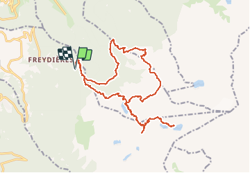
Randonnée Marche de 23 km à découvrir à Auvergne-Rhône-Alpes, Isère, Revel. Cette randonnée est proposée par zazie.
Description
Après une grosse montée, laisser sur votre gauche le sentier qui mène au refuge du Pré Mollard (chemin du retour) et suivre le chemin montant pour un accès rapide au refuge de la Pra.
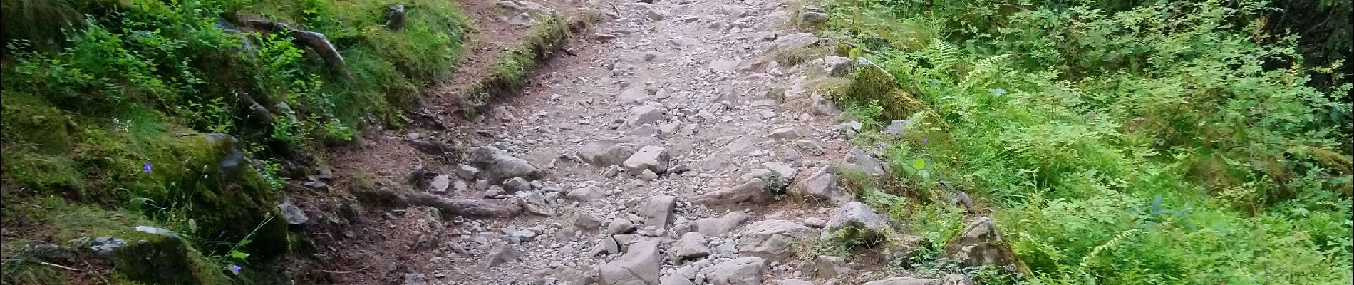
Liaison entre le lac de Crozet et le refuge de Pré Mollard par de très nombreux pierriers.
Liaison entre le second refuge et le chemin du parking part un sentier usé jalonné de prises d'eau et de cascades.
Attention, randonnée parfois aérienne.
Localisation
Commentaires
Randonnées à proximité
![Randonnée A pied La Combe-de-Lancey - Chemin de Découverte (boucle Haute) - Photo](https://media.geolcdn.com/t/375/260/6a0cb0d1-93da-4068-99ad-9a549161cacf.jpeg&format=jpg&maxdim=2)
![A pied A pied](https://static1.geolcdn.com/sitytour/trail-icons/100.png)
A pied
![](/images/other/stat-length.png)
![](https://static1.geolcdn.com/siteimages/upload/files/16400158638029165_repeat_loop_refresh_sync_direction_icon.png)
![Randonnée A pied Saint-Jean-le-Vieux - La Tour de Revel (par le Mollard) - Photo](https://media.geolcdn.com/t/375/260/9b2599de-7f79-405c-8210-bdfecfa7c849.jpeg&format=jpg&maxdim=2)
![A pied A pied](https://static1.geolcdn.com/sitytour/trail-icons/100.png)
A pied
![](/images/other/stat-length.png)
![](https://static1.geolcdn.com/siteimages/upload/files/16400158638029165_repeat_loop_refresh_sync_direction_icon.png)
![Randonnée Marche Chamrousse - lacs Robert - Photo](https://media.geolcdn.com/t/375/260/ext.jpg?maxdim=2&url=https%3A%2F%2Fstatic1.geolcdn.com%2Fsiteimages%2Fupload%2Ffiles%2F1553511878bg_sport_marche.png)
![Marche Marche](https://static1.geolcdn.com/sitytour/trail-icons/101.png)
Marche
![](/images/other/stat-length.png)
![](https://static1.geolcdn.com/siteimages/upload/files/16400158638029165_repeat_loop_refresh_sync_direction_icon.png)
![Randonnée Marche Saint-Martin-d'Uriage - Les Seiglières. Circuit des Gardes n°9 raccourci à 8 km - Photo](https://media.geolcdn.com/t/375/260/e86aee80-f13d-4d4a-be38-285e5f19658e.jpg&format=jpg&maxdim=2)
![Marche Marche](https://static1.geolcdn.com/sitytour/trail-icons/101.png)
Marche
![](/images/other/stat-length.png)
![](https://static1.geolcdn.com/siteimages/upload/files/16400158638029165_repeat_loop_refresh_sync_direction_icon.png)
![Randonnée Marche La Combe-de-Lancey - Col du Pré du Molard - Photo](https://media.geolcdn.com/t/375/260/29dc783a-080e-448f-b06b-b4c5ed8fc906.jpg&format=jpg&maxdim=2)
![Marche Marche](https://static1.geolcdn.com/sitytour/trail-icons/101.png)
Marche
![](/images/other/stat-length.png)
![](https://static1.geolcdn.com/siteimages/upload/files/16400158638029165_repeat_loop_refresh_sync_direction_icon.png)
![Randonnée Marche Saint-Mury-Monteymond - Lac Blanc au pied de Belledonne - Photo](https://media.geolcdn.com/t/375/260/be8bcf54-d056-4226-93e0-f27b8cc25845.jpg&format=jpg&maxdim=2)
![Marche Marche](https://static1.geolcdn.com/sitytour/trail-icons/101.png)
Marche
![](/images/other/stat-length.png)
![](https://static1.geolcdn.com/siteimages/upload/files/16400158638029165_repeat_loop_refresh_sync_direction_icon.png)
![Randonnée Marche Revel - Montagne 15/08/2023 - Photo](https://media.geolcdn.com/t/375/260/ca509cb3-3847-45e2-a337-c41964fdee08.jpg&format=jpg&maxdim=2)
![Marche Marche](https://static1.geolcdn.com/sitytour/trail-icons/101.png)
Marche
![](/images/other/stat-length.png)
![](https://static1.geolcdn.com/siteimages/upload/files/16400158638029165_repeat_loop_refresh_sync_direction_icon.png)
![Randonnée Marche Saint-Mury-Monteymond - Col et Pointe de la Sitre - Photo](https://media.geolcdn.com/t/375/260/12aa835d-a61b-4dc5-8899-8748a81192a8.jpg&format=jpg&maxdim=2)
![Marche Marche](https://static1.geolcdn.com/sitytour/trail-icons/101.png)
Marche
![](/images/other/stat-length.png)
![](https://static1.geolcdn.com/siteimages/upload/files/16400158638029165_repeat_loop_refresh_sync_direction_icon.png)
![Randonnée Marche Saint-Martin-d'Uriage - Circuit des Gardes - Photo](https://media.geolcdn.com/t/375/260/5aace18d-b6a8-46a3-a2a8-ee9515f27ad2.jpg&format=jpg&maxdim=2)
![Marche Marche](https://static1.geolcdn.com/sitytour/trail-icons/101.png)
Marche
![](/images/other/stat-length.png)
![](https://static1.geolcdn.com/siteimages/upload/files/16400158638029165_repeat_loop_refresh_sync_direction_icon.png)