![](/images/other/stat-length.png)
![Randonnée V.T.T. Saint-Crépin - Le lac Lauzet et les Grangettes au départ du villard de St-Crépin - Photo](https://media.geolcdn.com/t/1900/400/ext.pjpeg?maxdim=2&url=https%3A%2F%2Fstatic1.geolcdn.com%2Fsiteimages%2Fupload%2Ffiles%2F1524743154velo.jpg)
Le lac Lauzet et les Grangettes au départ du villard de St-Crépin
Forain
Utilisateur
![Longueur](/images/other/stat-length.png)
![Altitude max](https://static1.geolcdn.com/siteimages/upload/files/1508320355ic_sort_altitude_max_24dp.png)
![Dénivelé positif](https://static1.geolcdn.com/siteimages/upload/files/1508320355ic_sort_den_pos_24dp.png)
![Km-Effort](/images/other/stat-length.png)
![Altitude min](https://static1.geolcdn.com/siteimages/upload/files/1508320355ic_sort_altitude_min_24dp.png)
![Dénivelé négatif](https://static1.geolcdn.com/siteimages/upload/files/1508320355ic_sort_den_neg_24dp.png)
![Boucle](https://static1.geolcdn.com/siteimages/upload/files/16400158638029165_repeat_loop_refresh_sync_direction_icon.png)
![V.T.T.](https://static1.geolcdn.com/sitytour/trail-icons/202.png)
2h59
Difficulté : Difficile
![Scannez ce code QR pour ouvrir la randonnée dans l'application SityTrail](https://capi.geolives.com/qq0zvz2zws4bq2lad0pu/sitytour/trails/2498002/qr.png?size=200)
Application GPS de randonnée GRATUITE
À propos
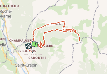
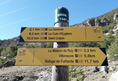
Randonnée V.T.T. de 22 km à découvrir à Provence-Alpes-Côte d'Azur, Hautes-Alpes, Saint-Crépin. Cette randonnée est proposée par Forain.
Description
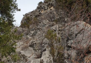
La montée est assez raide au début(4km) suivi d'une section plus roulante, suivi d'un final plus grimpant avec au sommet un petit lac d’altitude. Le retour ce fait par la voie de montée sur environ 1,7km avant de bifurquer sur un petit chemin de randonnée à droite(au niveau de la cabane du Lauzet) en direction des Grangettes. Le début de ce sentier est technique pour devenir de plus en plus roulant.
Localisation
Commentaires
Randonnées à proximité
![Randonnée Marche Freissinières - Crête en bordure vallée Freissinieres (Rortie) - Photo](https://media.geolcdn.com/t/375/260/ext.jpg?maxdim=2&url=https%3A%2F%2Fservices.sitytrail.com%2FGeolivesWS%2FDownloadMedia.ashx%3FTrailID%3D615510%26Media%3Dfix__20160816131321.jpg)
![Marche Marche](https://static1.geolcdn.com/sitytour/trail-icons/101.png)
Marche
![](/images/other/stat-length.png)
![](https://static1.geolcdn.com/siteimages/upload/files/16400158638029165_repeat_loop_refresh_sync_direction_icon.png)
![Randonnée Marche Eygliers - crots les Girars - Photo](https://media.geolcdn.com/t/375/260/1984f172-53b4-4530-81bd-f8dbb8a69056.jpg&format=jpg&maxdim=2)
![Marche Marche](https://static1.geolcdn.com/sitytour/trail-icons/101.png)
Marche
![](/images/other/stat-length.png)
![](https://static1.geolcdn.com/siteimages/upload/files/16400158638029165_repeat_loop_refresh_sync_direction_icon.png)
![Randonnée Marche Champcella - Gouffre de Gourfouran - Photo](https://media.geolcdn.com/t/375/260/e71c0816-5ea3-48b2-a638-eb4844c01261.jpg&format=jpg&maxdim=2)
![Marche Marche](https://static1.geolcdn.com/sitytour/trail-icons/101.png)
Marche
![](/images/other/stat-length.png)
![](https://static1.geolcdn.com/siteimages/upload/files/16400158638029165_repeat_loop_refresh_sync_direction_icon.png)
![Randonnée Marche Champcella - FRESSINIERES - SEYES 16.3KM - Photo](https://media.geolcdn.com/t/375/260/ext.jpg?maxdim=2&url=https%3A%2F%2Fservices.sitytrail.com%2FGeolivesWS%2FDownloadMedia.ashx%3FTrailID%3D453121%26Media%3Daf20fe3c-1968-4140-9440-e6d14a0bf00b.jpg)
![Marche Marche](https://static1.geolcdn.com/sitytour/trail-icons/101.png)
Marche
![](/images/other/stat-length.png)
![](https://static1.geolcdn.com/siteimages/upload/files/16400158638029165_repeat_loop_refresh_sync_direction_icon.png)
![Randonnée Marche Eygliers - eygliers - Photo](https://media.geolcdn.com/t/375/260/4d2fa757-82b4-42b5-b98d-a01be8317965.jpg&format=jpg&maxdim=2)
![Marche Marche](https://static1.geolcdn.com/sitytour/trail-icons/101.png)
Marche
![](/images/other/stat-length.png)
![](https://static1.geolcdn.com/siteimages/upload/files/16400158638029165_repeat_loop_refresh_sync_direction_icon.png)
![Randonnée Marche Saint-Crépin - St Crépin Thurifère vers hameau de Guion Chantal - Photo](https://media.geolcdn.com/t/375/260/c1ee07d4-05f0-443a-a59c-bf145194c732.jpg&format=jpg&maxdim=2)
![Marche Marche](https://static1.geolcdn.com/sitytour/trail-icons/101.png)
Marche
![](/images/other/stat-length.png)
![](https://static1.geolcdn.com/siteimages/upload/files/16400158638029165_repeat_loop_refresh_sync_direction_icon.png)
![Randonnée Marche Eygliers - Gros cabannes Tourouder - Photo](https://media.geolcdn.com/t/375/260/316d45c1-9e6e-42ed-8767-48fc2893efef.jpg&format=jpg&maxdim=2)
![Marche Marche](https://static1.geolcdn.com/sitytour/trail-icons/101.png)
Marche
![](/images/other/stat-length.png)
![](https://static1.geolcdn.com/siteimages/upload/files/16400158638029165_repeat_loop_refresh_sync_direction_icon.png)
![Randonnée Marche Champcella - 2020-09-10 Balade Gouffre du Gourfouran - Photo](https://media.geolcdn.com/t/375/260/bfedcf14-c21e-4e5e-9a44-ef10f0f1a645.jpg&format=jpg&maxdim=2)
![Marche Marche](https://static1.geolcdn.com/sitytour/trail-icons/101.png)
Marche
![](/images/other/stat-length.png)
![](https://static1.geolcdn.com/siteimages/upload/files/16400158638029165_repeat_loop_refresh_sync_direction_icon.png)
![Randonnée Marche La Roche-de-Rame - Le Pic du haut Mouriare et le lac de l'Ascension - Photo](https://media.geolcdn.com/t/375/260/8e7aa451-d695-4417-922a-7f908363131f.jpg&format=jpg&maxdim=2)
![Marche Marche](https://static1.geolcdn.com/sitytour/trail-icons/101.png)
Marche
![](/images/other/stat-length.png)
![](https://static1.geolcdn.com/siteimages/upload/files/16400158638029165_repeat_loop_refresh_sync_direction_icon.png)