![](/images/other/stat-length.png)
![Randonnée V.T.T. Rodez - Rodez Agglomeration - Circuit 6 - Le bois de l?ours - Photo](https://media.geolcdn.com/t/1900/400/78030542-0853-4f3f-94af-6b278eb696ba.jpg&format=pjpeg&maxdim=2)
Rodez Agglomeration - Circuit 6 - Le bois de l?ours
randoruthene
Utilisateur
![Longueur](/images/other/stat-length.png)
![Altitude max](https://static1.geolcdn.com/siteimages/upload/files/1508320355ic_sort_altitude_max_24dp.png)
![Dénivelé positif](https://static1.geolcdn.com/siteimages/upload/files/1508320355ic_sort_den_pos_24dp.png)
![Km-Effort](/images/other/stat-length.png)
![Altitude min](https://static1.geolcdn.com/siteimages/upload/files/1508320355ic_sort_altitude_min_24dp.png)
![Dénivelé négatif](https://static1.geolcdn.com/siteimages/upload/files/1508320355ic_sort_den_neg_24dp.png)
![Boucle](https://static1.geolcdn.com/siteimages/upload/files/16400158638029165_repeat_loop_refresh_sync_direction_icon.png)
![V.T.T.](https://static1.geolcdn.com/sitytour/trail-icons/202.png)
3h11
Difficulté : Très difficile
![Scannez ce code QR pour ouvrir la randonnée dans l'application SityTrail](https://capi.geolives.com/qq0zvz2zws4bq2lad0pu/sitytour/trails/2492072/qr.png?size=200)
Application GPS de randonnée GRATUITE
À propos
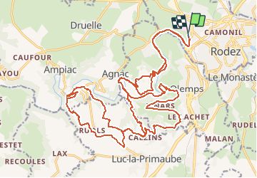
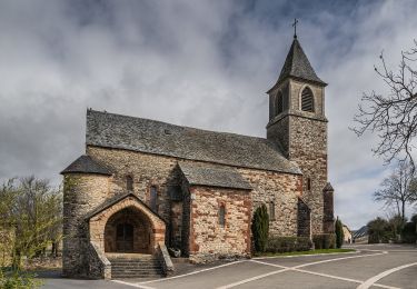
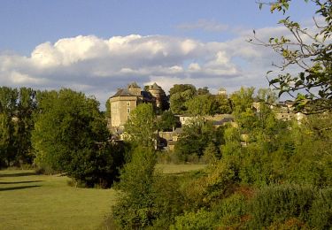
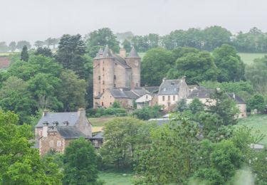
Randonnée V.T.T. de 36 km à découvrir à Occitanie, Aveyron, Rodez. Cette randonnée est proposée par randoruthene.
Description
Espace VTT Rodez Agglo - 400 km de chemins balisés - 18 circuits labéllisés FFC
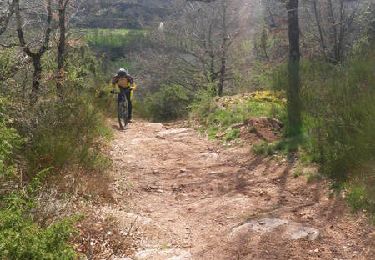
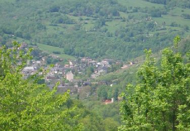
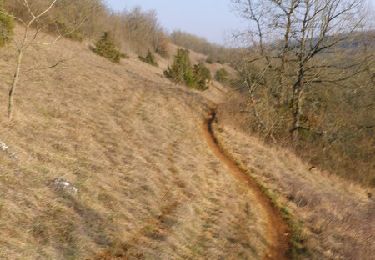
Ce circuit rouge est vallonné et varié avec des passages exigeants. Il offre de superbes points de vue sur la vallée de l’Aveyron, avec des passages en forêt, en plateaux, avec du technique, du roulant : il y en a pour tous les goûts.
Localisation
Commentaires
Randonnées à proximité
![Randonnée V.T.T. Druelle Balsac - Autour de l'Aveyron de Agnac à Ampiac - Photo](https://media.geolcdn.com/t/375/260/ext.jpg?maxdim=2&url=https%3A%2F%2Fservices.sitytrail.com%2FGeolivesWS%2FDownloadMedia.ashx%3FTrailID%3D129771%26Media%3D13313_6.jpg)
![V.T.T. V.T.T.](https://static1.geolcdn.com/sitytour/trail-icons/202.png)
V.T.T.
![](/images/other/stat-length.png)
![](https://static1.geolcdn.com/siteimages/upload/files/16400158638029165_repeat_loop_refresh_sync_direction_icon.png)
![Randonnée V.T.T. Onet-le-Château - Randonnée VTT boucle d'Onet le Château à Macillac - Photo](https://media.geolcdn.com/t/375/260/ext.jpg?maxdim=2&url=https%3A%2F%2Fservices.sitytrail.com%2FGeolivesWS%2FDownloadMedia.ashx%3FTrailID%3D106486%26Media%3D11020_6.jpg)
![V.T.T. V.T.T.](https://static1.geolcdn.com/sitytour/trail-icons/202.png)
V.T.T.
![](/images/other/stat-length.png)
![](https://static1.geolcdn.com/siteimages/upload/files/16400158638029165_repeat_loop_refresh_sync_direction_icon.png)
![Randonnée V.T.T. Onet-le-Château - Onet - Mondalazac - Onet - Photo](https://media.geolcdn.com/t/375/260/ext.jpg?maxdim=2&url=https%3A%2F%2Fservices.sitytrail.com%2FGeolivesWS%2FDownloadMedia.ashx%3FTrailID%3D106177%26Media%3D10451_6.jpg)
![V.T.T. V.T.T.](https://static1.geolcdn.com/sitytour/trail-icons/202.png)
V.T.T.
![](/images/other/stat-length.png)
![](https://static1.geolcdn.com/siteimages/upload/files/16400158638029165_repeat_loop_refresh_sync_direction_icon.png)
![Randonnée A pied Rodez - Randonnée de Rodez Agglomération Circuit n°2 - Layoule - Photo](https://media.geolcdn.com/t/375/260/f3313b5c-ce65-4318-890f-b27e77cbc381.jpeg&format=jpg&maxdim=2)
![A pied A pied](https://static1.geolcdn.com/sitytour/trail-icons/100.png)
A pied
![](/images/other/stat-length.png)
![](https://static1.geolcdn.com/siteimages/upload/files/16400158638029165_repeat_loop_refresh_sync_direction_icon.png)
![Randonnée A pied Onet-le-Château - Circuit 20 Vabres - Photo](https://media.geolcdn.com/t/375/260/1433d9f6-de3b-438e-a0f0-7d050107ea52.jpeg&format=jpg&maxdim=2)
![A pied A pied](https://static1.geolcdn.com/sitytour/trail-icons/100.png)
A pied
![](/images/other/stat-length.png)
![](https://static1.geolcdn.com/siteimages/upload/files/16400158638029165_repeat_loop_refresh_sync_direction_icon.png)
![Randonnée A pied Onet-le-Château - Circuit 16 Moulin de cantarane - Photo](https://media.geolcdn.com/t/375/260/235c9653-a6cd-4d3e-a1cf-bad11a8eacbc.jpeg&format=jpg&maxdim=2)
![A pied A pied](https://static1.geolcdn.com/sitytour/trail-icons/100.png)
A pied
![](/images/other/stat-length.png)
![](https://static1.geolcdn.com/siteimages/upload/files/16400158638029165_repeat_loop_refresh_sync_direction_icon.png)
![Randonnée A pied Le Monastère - Circuit 11 Le Monsastère - Photo](https://media.geolcdn.com/t/375/260/7f6d0b8f-df20-456a-b847-03e2bacf2452.jpeg&format=jpg&maxdim=2)
![A pied A pied](https://static1.geolcdn.com/sitytour/trail-icons/100.png)
A pied
![](/images/other/stat-length.png)
![](https://static1.geolcdn.com/siteimages/upload/files/16400158638029165_repeat_loop_refresh_sync_direction_icon.png)
![Randonnée A pied Luc-la-Primaube - Circuit 9 Planèzes - Photo](https://media.geolcdn.com/t/375/260/5a6f95bc-d295-4447-ad49-16f1eeefb33a.jpeg&format=jpg&maxdim=2)
![A pied A pied](https://static1.geolcdn.com/sitytour/trail-icons/100.png)
A pied
![](/images/other/stat-length.png)
![](https://static1.geolcdn.com/siteimages/upload/files/16400158638029165_repeat_loop_refresh_sync_direction_icon.png)
![Randonnée A pied Olemps - Circuit 8 Le Viel Olemps - Photo](https://media.geolcdn.com/t/375/260/eb25fc91-7c0e-4dc4-8e2b-7796a039a790.jpeg&format=jpg&maxdim=2)
![A pied A pied](https://static1.geolcdn.com/sitytour/trail-icons/100.png)
A pied
![](/images/other/stat-length.png)
![](https://static1.geolcdn.com/siteimages/upload/files/16400158638029165_repeat_loop_refresh_sync_direction_icon.png)