![](/images/other/stat-length.png)
![Randonnée V.T.T. Luc-la-Primaube - Rodez Agglomeration - Circuit 3 - Au fil de la Brienne - Photo](https://media.geolcdn.com/t/1900/400/2d488229-e470-4b33-a498-e1653098ca57.jpg&format=pjpeg&maxdim=2)
Rodez Agglomeration - Circuit 3 - Au fil de la Brienne
randoruthene
Utilisateur
![Longueur](/images/other/stat-length.png)
![Altitude max](https://static1.geolcdn.com/siteimages/upload/files/1508320355ic_sort_altitude_max_24dp.png)
![Dénivelé positif](https://static1.geolcdn.com/siteimages/upload/files/1508320355ic_sort_den_pos_24dp.png)
![Km-Effort](/images/other/stat-length.png)
![Altitude min](https://static1.geolcdn.com/siteimages/upload/files/1508320355ic_sort_altitude_min_24dp.png)
![Dénivelé négatif](https://static1.geolcdn.com/siteimages/upload/files/1508320355ic_sort_den_neg_24dp.png)
![Boucle](https://static1.geolcdn.com/siteimages/upload/files/16400158638029165_repeat_loop_refresh_sync_direction_icon.png)
![V.T.T.](https://static1.geolcdn.com/sitytour/trail-icons/202.png)
1h57
Difficulté : Moyen
![Scannez ce code QR pour ouvrir la randonnée dans l'application SityTrail](https://capi.geolives.com/qq0zvz2zws4bq2lad0pu/sitytour/trails/2492060/qr.png?size=200)
Application GPS de randonnée GRATUITE
À propos
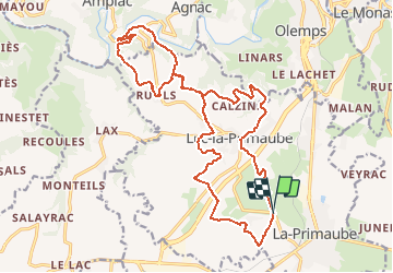
Randonnée V.T.T. de 23 km à découvrir à Occitanie, Aveyron, Luc-la-Primaube. Cette randonnée est proposée par randoruthene.
Description
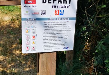
Espace VTT Rodez Agglo - 400 km de chemins balisés - 18 circuits labéllisés FFC
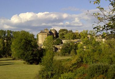
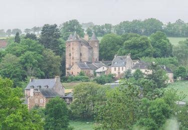
Pour ce circuit rouge, vous partirez du lac de Planèzes.
A noter qu’à proximité de ce lac, vous pourrez découvrir le château de Planèzes, dont la construction a débuté au XVe siècle. Avec ce château notamment, la commune conserve quelques souvenirs du village médiéval.
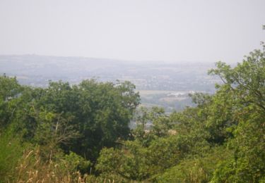
Ce parcours vous amènera ensuite dans la vallée de l’Aveyron par des chemins forestiers avec quelques passages techniques.
Localisation
Commentaires
Randonnées à proximité
![Randonnée A pied Le Monastère - Circuit 11 Le Monsastère - Photo](https://media.geolcdn.com/t/375/260/7f6d0b8f-df20-456a-b847-03e2bacf2452.jpeg&format=jpg&maxdim=2)
![A pied A pied](https://static1.geolcdn.com/sitytour/trail-icons/100.png)
A pied
![](/images/other/stat-length.png)
![](https://static1.geolcdn.com/siteimages/upload/files/16400158638029165_repeat_loop_refresh_sync_direction_icon.png)
![Randonnée A pied Luc-la-Primaube - Circuit 10 La Capelle Saint-Martin - Photo](https://media.geolcdn.com/t/375/260/5a6f95bc-d295-4447-ad49-16f1eeefb33a.jpeg&format=jpg&maxdim=2)
![A pied A pied](https://static1.geolcdn.com/sitytour/trail-icons/100.png)
A pied
![](/images/other/stat-length.png)
![](https://static1.geolcdn.com/siteimages/upload/files/16400158638029165_repeat_loop_refresh_sync_direction_icon.png)
![Randonnée A pied Luc-la-Primaube - Circuit 9 Planèzes - Photo](https://media.geolcdn.com/t/375/260/5a6f95bc-d295-4447-ad49-16f1eeefb33a.jpeg&format=jpg&maxdim=2)
![A pied A pied](https://static1.geolcdn.com/sitytour/trail-icons/100.png)
A pied
![](/images/other/stat-length.png)
![](https://static1.geolcdn.com/siteimages/upload/files/16400158638029165_repeat_loop_refresh_sync_direction_icon.png)
![Randonnée A pied Olemps - Circuit 8 Le Viel Olemps - Photo](https://media.geolcdn.com/t/375/260/eb25fc91-7c0e-4dc4-8e2b-7796a039a790.jpeg&format=jpg&maxdim=2)
![A pied A pied](https://static1.geolcdn.com/sitytour/trail-icons/100.png)
A pied
![](/images/other/stat-length.png)
![](https://static1.geolcdn.com/siteimages/upload/files/16400158638029165_repeat_loop_refresh_sync_direction_icon.png)
![Randonnée A pied Rodez - Via Piodensis - Rodez - Photo](https://media.geolcdn.com/t/375/260/9dd22525-ee44-4bef-976c-a9f96d351214.jpeg&format=jpg&maxdim=2)
![A pied A pied](https://static1.geolcdn.com/sitytour/trail-icons/100.png)
A pied
![](/images/other/stat-length.png)
![](https://static1.geolcdn.com/siteimages/upload/files/16400158638029165_repeat_loop_refresh_sync_direction_icon.png)
![Randonnée V.T.T. Luc-la-Primaube - Rodez Agglomeration - Circuit 4 - Les trois châteaux - Photo](https://media.geolcdn.com/t/375/260/cad89de7-cb4b-41dc-82e7-04ffbe1dbde1.jpg&format=jpg&maxdim=2)
![V.T.T. V.T.T.](https://static1.geolcdn.com/sitytour/trail-icons/202.png)
V.T.T.
![](/images/other/stat-length.png)
![](https://static1.geolcdn.com/siteimages/upload/files/16400158638029165_repeat_loop_refresh_sync_direction_icon.png)
![Randonnée V.T.T. Sainte-Radegonde - Combelles et les Crêtes - Photo](https://media.geolcdn.com/t/375/260/ext.jpg?maxdim=2&url=https%3A%2F%2Fservices.sitytrail.com%2FGeolivesWS%2FDownloadMedia.ashx%3FTrailID%3D172638%26Media%3D14007_2.jpg)
![V.T.T. V.T.T.](https://static1.geolcdn.com/sitytour/trail-icons/202.png)
V.T.T.
![](/images/other/stat-length.png)
![](https://static1.geolcdn.com/siteimages/upload/files/16400158638029165_repeat_loop_refresh_sync_direction_icon.png)
![Randonnée A pied Olemps - Circuit 6 Toizac - Photo](https://media.geolcdn.com/t/375/260/ext.jpg?maxdim=2&url=https%3A%2F%2Fstatic1.geolcdn.com%2Fsiteimages%2Fupload%2Ffiles%2F1545311037marcheuse_200dpi.jpg)
![A pied A pied](https://static1.geolcdn.com/sitytour/trail-icons/100.png)
![Randonnée V.T.T. Olemps - Rodez Agglomeration - Circuit 15 - Les Ballades - Photo](https://media.geolcdn.com/t/375/260/de43fcb9-2070-4512-bae5-91ee5485dcf0.jpg&format=jpg&maxdim=2)
![V.T.T. V.T.T.](https://static1.geolcdn.com/sitytour/trail-icons/202.png)
V.T.T.
![](/images/other/stat-length.png)
![](https://static1.geolcdn.com/siteimages/upload/files/16400158638029165_repeat_loop_refresh_sync_direction_icon.png)