![](/images/other/stat-length.png)
![Randonnée Marche Mettray - Mettray - Dolmen - 12.9km 160m 2h40 - 2020 07 26 - Photo](https://media.geolcdn.com/t/1900/400/7eb82ac0-48df-4237-a483-c208fe4e7abd.jpg&format=pjpeg&maxdim=2)
Mettray - Dolmen - 12.9km 160m 2h40 - 2020 07 26
Orcal37
Utilisateur GUIDE
![Longueur](/images/other/stat-length.png)
Longueur
12,9 km
![Altitude max](https://static1.geolcdn.com/siteimages/upload/files/1508320355ic_sort_altitude_max_24dp.png)
Altitude max
100 m
![Dénivelé positif](https://static1.geolcdn.com/siteimages/upload/files/1508320355ic_sort_den_pos_24dp.png)
Dénivelé positif
161 m
![Km-Effort](/images/other/stat-length.png)
Km-Effort
15 km
![Altitude min](https://static1.geolcdn.com/siteimages/upload/files/1508320355ic_sort_altitude_min_24dp.png)
Altitude min
51 m
![Dénivelé négatif](https://static1.geolcdn.com/siteimages/upload/files/1508320355ic_sort_den_neg_24dp.png)
Dénivelé négatif
163 m
![Boucle](https://static1.geolcdn.com/siteimages/upload/files/16400158638029165_repeat_loop_refresh_sync_direction_icon.png)
Boucle
Oui
Date de création :
2020-07-26 12:25:00.672
Dernière modification :
2020-07-27 09:43:37.254
![Marche](https://static1.geolcdn.com/sitytour/trail-icons/101.png)
2h40
Difficulté : Facile
![Scannez ce code QR pour ouvrir la randonnée dans l'application SityTrail](https://capi.geolives.com/qq0zvz2zws4bq2lad0pu/sitytour/trails/2491226/qr.png?size=200)
Application GPS de randonnée GRATUITE
À propos
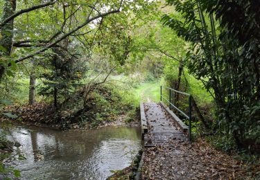
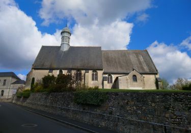
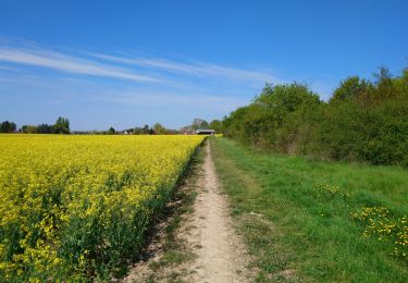
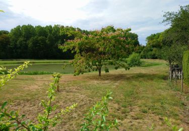
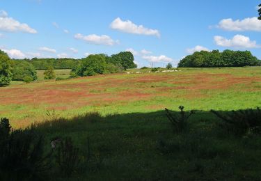
Randonnée Marche de 12,9 km à découvrir à Centre-Val de Loire, Indre-et-Loire, Mettray. Cette randonnée est proposée par Orcal37.
Description
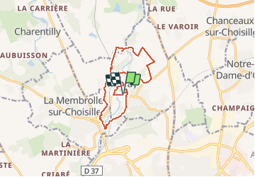
Mettray - Dolmen de la Grotte aux Fées - plan d'eau de La Membrolle-sur-Choisille - 12.9km 160m 2h40 - 2020 07 26
Localisation
Pays :
France
Région :
Centre-Val de Loire
Département/Province :
Indre-et-Loire
Commune :
Mettray
Localité :
Unknown
Départ:(Dec)
Départ:(UTM)
322892 ; 5257705 (31T) N.
Commentaires
Randonnées à proximité
![Randonnée Marche Saint-Cyr-sur-Loire - Saint-Cyr-sur-Loire la Gagnerie - la Membrolle-sur-Choisille Mettray - 24km 405m 5h15 (50mn) - 2024 10 20 - Photo](https://media.geolcdn.com/t/375/260/21cd2b46-14f0-4eaa-a3c8-0e5f8e58cc4a.jpg&format=jpg&maxdim=2)
![Marche Marche](https://static1.geolcdn.com/sitytour/trail-icons/101.png)
Saint-Cyr-sur-Loire la Gagnerie - la Membrolle-sur-Choisille Mettray - 24km 4...
Marche
Moyen
Saint-Cyr-sur-Loire,
Centre-Val de Loire,
Indre-et-Loire,
France
![](/images/other/stat-length.png)
24 km | 29 km-effort
5h 15min
![](https://static1.geolcdn.com/siteimages/upload/files/16400158638029165_repeat_loop_refresh_sync_direction_icon.png)
Oui
![Randonnée Marche Fondettes - Fondettes Charcenay - Sentier Val de Choisille avec variantes - 23.5km 335m 5h10 (55mn) - 2024 10 13 - Photo](https://media.geolcdn.com/t/375/260/da5cdfb1-5871-4878-b704-e11c5bcbf000.jpg&format=jpg&maxdim=2)
![Marche Marche](https://static1.geolcdn.com/sitytour/trail-icons/101.png)
Fondettes Charcenay - Sentier Val de Choisille avec variantes - 23.5km 335m 5...
Marche
Facile
Fondettes,
Centre-Val de Loire,
Indre-et-Loire,
France
![](/images/other/stat-length.png)
23 km | 28 km-effort
5h 10min
![](https://static1.geolcdn.com/siteimages/upload/files/16400158638029165_repeat_loop_refresh_sync_direction_icon.png)
Oui
![Randonnée Marche Saint-Antoine-du-Rocher - Saint-Antoine-du-Rocher - Rouziers-de-Touraine - 21.4km 165m 4h55 - 2022 04 03 - Photo](https://media.geolcdn.com/t/375/260/8b36e295-8247-4873-9751-f344e6172f47.jpg&format=jpg&maxdim=2)
![Marche Marche](https://static1.geolcdn.com/sitytour/trail-icons/101.png)
Saint-Antoine-du-Rocher - Rouziers-de-Touraine - 21.4km 165m 4h55 - 2022 04 03
Marche
Facile
Saint-Antoine-du-Rocher,
Centre-Val de Loire,
Indre-et-Loire,
France
![](/images/other/stat-length.png)
21 km | 24 km-effort
4h 55min
![](https://static1.geolcdn.com/siteimages/upload/files/16400158638029165_repeat_loop_refresh_sync_direction_icon.png)
Oui
![Randonnée Marche Fondettes - Fondettes - Impro 4 communes - 21.6km 200m 4h40 (30mn) - 2021 04 24 - Photo](https://media.geolcdn.com/t/375/260/8360f715-226c-4f82-afa7-992b48458f8c.jpg&format=jpg&maxdim=2)
![Marche Marche](https://static1.geolcdn.com/sitytour/trail-icons/101.png)
Fondettes - Impro 4 communes - 21.6km 200m 4h40 (30mn) - 2021 04 24
Marche
Facile
Fondettes,
Centre-Val de Loire,
Indre-et-Loire,
France
![](/images/other/stat-length.png)
22 km | 24 km-effort
4h 40min
![](https://static1.geolcdn.com/siteimages/upload/files/16400158638029165_repeat_loop_refresh_sync_direction_icon.png)
Oui
![Randonnée Marche Charentilly - Charentilly - PR la Choisillette avec variante - 9km 100m 1h50 - 2020 11 28 - Photo](https://media.geolcdn.com/t/375/260/c1b744c0-bc06-4fe5-a4fc-24f9728adfe5.jpg&format=jpg&maxdim=2)
![Marche Marche](https://static1.geolcdn.com/sitytour/trail-icons/101.png)
Charentilly - PR la Choisillette avec variante - 9km 100m 1h50 - 2020 11 28
Marche
Facile
Charentilly,
Centre-Val de Loire,
Indre-et-Loire,
France
![](/images/other/stat-length.png)
9 km | 10,4 km-effort
1h 50min
![](https://static1.geolcdn.com/siteimages/upload/files/16400158638029165_repeat_loop_refresh_sync_direction_icon.png)
Oui
![Randonnée Marche Charentilly - Charentilly - Circuit 2 avec variante - 14.8km 135m 3h05 - 2020 08 15 - Photo](https://media.geolcdn.com/t/375/260/3d2c51a1-3af7-44d8-bc0c-6a33566d6f6e.jpg&format=jpg&maxdim=2)
![Marche Marche](https://static1.geolcdn.com/sitytour/trail-icons/101.png)
Charentilly - Circuit 2 avec variante - 14.8km 135m 3h05 - 2020 08 15
Marche
Facile
Charentilly,
Centre-Val de Loire,
Indre-et-Loire,
France
![](/images/other/stat-length.png)
14,8 km | 16,6 km-effort
3h 5min
![](https://static1.geolcdn.com/siteimages/upload/files/16400158638029165_repeat_loop_refresh_sync_direction_icon.png)
Oui
![Randonnée Marche La Membrolle-sur-Choisille - La Membrolle-sur-Choisille - sentier Petite Choisille - 11.9km 170m 2h30 - 2020 07 24 - Photo](https://media.geolcdn.com/t/375/260/f6ef86c8-3755-4875-9651-44b6a31fd08c.jpg&format=jpg&maxdim=2)
![Marche Marche](https://static1.geolcdn.com/sitytour/trail-icons/101.png)
La Membrolle-sur-Choisille - sentier Petite Choisille - 11.9km 170m 2h30 - 20...
Marche
Facile
La Membrolle-sur-Choisille,
Centre-Val de Loire,
Indre-et-Loire,
France
![](/images/other/stat-length.png)
11,9 km | 14,2 km-effort
2h 30min
![](https://static1.geolcdn.com/siteimages/upload/files/16400158638029165_repeat_loop_refresh_sync_direction_icon.png)
Oui
![Randonnée Marche Chanceaux-sur-Choisille - Chanceaux-sur-Choisille - Sentier découverte - 14.1km 130m 2h55 - 2019 05 12 - Photo](https://media.geolcdn.com/t/375/260/bca621a1-a85c-4e84-a79a-18fb7885ed73.jpg&format=jpg&maxdim=2)
![Marche Marche](https://static1.geolcdn.com/sitytour/trail-icons/101.png)
Chanceaux-sur-Choisille - Sentier découverte - 14.1km 130m 2h55 - 2019 05 12
Marche
Facile
Chanceaux-sur-Choisille,
Centre-Val de Loire,
Indre-et-Loire,
France
![](/images/other/stat-length.png)
14,1 km | 15,8 km-effort
2h 55min
![](https://static1.geolcdn.com/siteimages/upload/files/16400158638029165_repeat_loop_refresh_sync_direction_icon.png)
Oui
![Randonnée Marche Mettray - Mettray - Sentier de la Grotte aux Fées - Photo](https://media.geolcdn.com/t/375/260/0d3020ff-602a-4622-830d-5eed4789d621.jpg&format=jpg&maxdim=2)
![Marche Marche](https://static1.geolcdn.com/sitytour/trail-icons/101.png)
Mettray - Sentier de la Grotte aux Fées
Marche
Moyen
Mettray,
Centre-Val de Loire,
Indre-et-Loire,
France
![](/images/other/stat-length.png)
9,6 km | 11 km-effort
2h 30min
![](https://static1.geolcdn.com/siteimages/upload/files/16400158638029165_repeat_loop_refresh_sync_direction_icon.png)
Oui