![](/images/other/stat-length.png)
![Randonnée A pied Audinghen - circuit du cap gris nez à Wissant - Photo](https://media.geolcdn.com/t/1900/400/503b72ca-bc97-4d76-b1ad-17cde1c6076f.jpg&format=pjpeg&maxdim=2)
circuit du cap gris nez à Wissant
Templeuveenmarche
Utilisateur
![Longueur](/images/other/stat-length.png)
Longueur
15,2 km
![Altitude max](https://static1.geolcdn.com/siteimages/upload/files/1508320355ic_sort_altitude_max_24dp.png)
Altitude max
56 m
![Dénivelé positif](https://static1.geolcdn.com/siteimages/upload/files/1508320355ic_sort_den_pos_24dp.png)
Dénivelé positif
180 m
![Km-Effort](/images/other/stat-length.png)
Km-Effort
17,6 km
![Altitude min](https://static1.geolcdn.com/siteimages/upload/files/1508320355ic_sort_altitude_min_24dp.png)
Altitude min
0 m
![Dénivelé négatif](https://static1.geolcdn.com/siteimages/upload/files/1508320355ic_sort_den_neg_24dp.png)
Dénivelé négatif
178 m
![Boucle](https://static1.geolcdn.com/siteimages/upload/files/16400158638029165_repeat_loop_refresh_sync_direction_icon.png)
Boucle
Oui
Date de création :
2020-07-23 09:40:25.427
Dernière modification :
2024-07-23 06:32:14.286
![A pied](https://static1.geolcdn.com/sitytour/trail-icons/100.png)
4h00
Difficulté : Facile
![Scannez ce code QR pour ouvrir la randonnée dans l'application SityTrail](https://capi.geolives.com/qq0zvz2zws4bq2lad0pu/sitytour/trails/2487371/qr.png?size=200)
Application GPS de randonnée GRATUITE
À propos
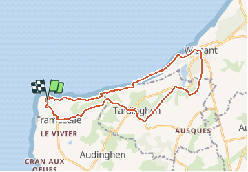
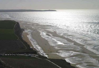
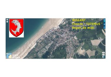
Randonnée A pied de 15,2 km à découvrir à Hauts-de-France, Pas-de-Calais, Audinghen. Cette randonnée est proposée par Templeuveenmarche.
Description
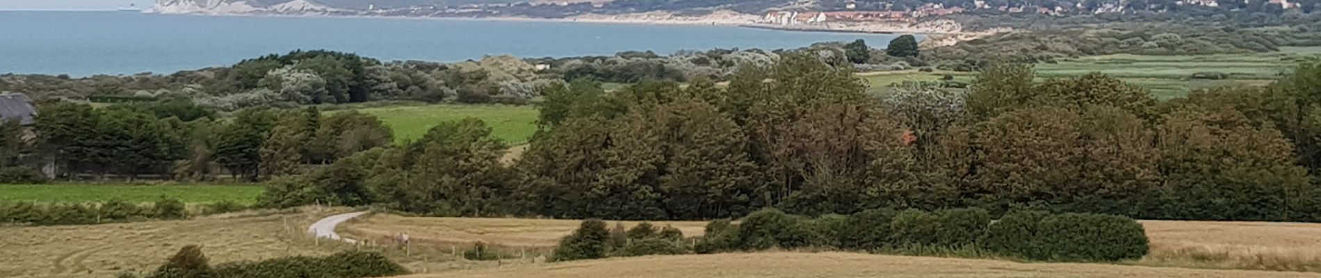
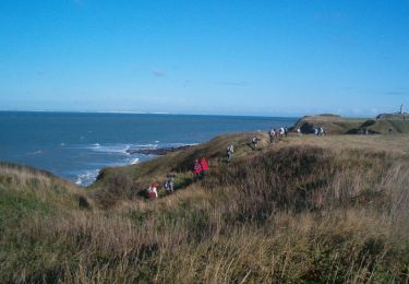
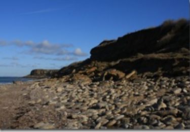
Cette belle randonnée nous fait découvrir le littoral et aussi l'arrière pays autour du cap gris nez. Des paysages somptueux entre mer et campagne.
Localisation
Pays :
France
Région :
Hauts-de-France
Département/Province :
Pas-de-Calais
Commune :
Audinghen
Localité :
Unknown
Départ:(Dec)
Départ:(UTM)
400829 ; 5636281 (31U) N.
Commentaires
Randonnées à proximité
![Randonnée Marche Wissant - Le Fartz - Photo](https://media.geolcdn.com/t/375/260/21ada877-513c-478a-b332-d0dc0a2aace8.jpg&format=jpg&maxdim=2)
![Marche Marche](https://static1.geolcdn.com/sitytour/trail-icons/101.png)
Le Fartz
Marche
Très facile
(1)
Wissant,
Hauts-de-France,
Pas-de-Calais,
France
![](/images/other/stat-length.png)
5,5 km | 6,2 km-effort
1h 29min
![](https://static1.geolcdn.com/siteimages/upload/files/16400158638029165_repeat_loop_refresh_sync_direction_icon.png)
Oui
![Randonnée Marche Tardinghen - Le Site des 2 Caps - Le Sentier des Crans - Photo](https://media.geolcdn.com/t/375/260/ext.jpg?maxdim=2&url=https%3A%2F%2Fservices.sitytrail.com%2FGeolivesWS%2FDownloadMedia.ashx%3FTrailID%3D109462%26Media%3D3985_6.jpg)
![Marche Marche](https://static1.geolcdn.com/sitytour/trail-icons/101.png)
Le Site des 2 Caps - Le Sentier des Crans
Marche
Moyen
(2)
Tardinghen,
Hauts-de-France,
Pas-de-Calais,
France
![](/images/other/stat-length.png)
12 km | 14,3 km-effort
3h 0min
![](https://static1.geolcdn.com/siteimages/upload/files/16400158638029165_repeat_loop_refresh_sync_direction_icon.png)
Oui
![Randonnée Marche Audinghen - Sentier cotier Audresselles - Audinghen - Photo](https://media.geolcdn.com/t/375/260/ext.jpg?maxdim=2&url=https%3A%2F%2Fservices.sitytrail.com%2FGeolivesWS%2FDownloadMedia.ashx%3FTrailID%3D106662%26Media%3D11283_3.jpg)
![Marche Marche](https://static1.geolcdn.com/sitytour/trail-icons/101.png)
Sentier cotier Audresselles - Audinghen
Marche
Moyen
(1)
Audinghen,
Hauts-de-France,
Pas-de-Calais,
France
![](/images/other/stat-length.png)
5,8 km | 7 km-effort
1h 30min
![](https://static1.geolcdn.com/siteimages/upload/files/16400158638029165_repeat_loop_refresh_sync_direction_icon.png)
Oui
![Randonnée Marche Tardinghen - Sentier du Fartz - Waissant - Photo](https://media.geolcdn.com/t/375/260/ext.jpg?maxdim=2&url=https%3A%2F%2Fservices.sitytrail.com%2FGeolivesWS%2FDownloadMedia.ashx%3FTrailID%3D106661%26Media%3D11281_6.jpg)
![Marche Marche](https://static1.geolcdn.com/sitytour/trail-icons/101.png)
Sentier du Fartz - Waissant
Marche
Facile
(1)
Tardinghen,
Hauts-de-France,
Pas-de-Calais,
France
![](/images/other/stat-length.png)
5,1 km | 5,8 km-effort
1h 30min
![](https://static1.geolcdn.com/siteimages/upload/files/16400158638029165_repeat_loop_refresh_sync_direction_icon.png)
Oui
![Randonnée Marche Audinghen - Circuit du Cap Gris-Nez - Photo](https://media.geolcdn.com/t/375/260/ext.jpg?maxdim=2&url=https%3A%2F%2Fservices.sitytrail.com%2FGeolivesWS%2FDownloadMedia.ashx%3FTrailID%3D467217%26Media%3D8e13a12a-37c7-44c3-b5de-cef39bc6199a.jpg)
![Marche Marche](https://static1.geolcdn.com/sitytour/trail-icons/101.png)
Circuit du Cap Gris-Nez
Marche
Très difficile
(1)
Audinghen,
Hauts-de-France,
Pas-de-Calais,
France
![](/images/other/stat-length.png)
27 km | 31 km-effort
7h 0min
![](https://static1.geolcdn.com/siteimages/upload/files/16400158638029165_repeat_loop_refresh_sync_direction_icon.png)
Oui
![Randonnée Marche Audinghen - Circuit du Cap Gris-Nez - Photo](https://media.geolcdn.com/t/375/260/ext.jpg?maxdim=2&url=https%3A%2F%2Fservices.sitytrail.com%2FGeolivesWS%2FDownloadMedia.ashx%3FTrailID%3D109809%26Media%3D4750_2.jpg)
![Marche Marche](https://static1.geolcdn.com/sitytour/trail-icons/101.png)
Circuit du Cap Gris-Nez
Marche
Très difficile
(1)
Audinghen,
Hauts-de-France,
Pas-de-Calais,
France
![](/images/other/stat-length.png)
27 km | 31 km-effort
7h 0min
![](https://static1.geolcdn.com/siteimages/upload/files/16400158638029165_repeat_loop_refresh_sync_direction_icon.png)
Oui
![Randonnée Marche Tardinghen - Le Site des 2 Caps - Le Sentier des Crans - Photo](https://media.geolcdn.com/t/375/260/ext.jpg?maxdim=2&url=https%3A%2F%2Fstatic1.geolcdn.com%2Fsiteimages%2Fupload%2Ffiles%2F1553511878bg_sport_marche.png)
![Marche Marche](https://static1.geolcdn.com/sitytour/trail-icons/101.png)
Le Site des 2 Caps - Le Sentier des Crans
Marche
Facile
(3)
Tardinghen,
Hauts-de-France,
Pas-de-Calais,
France
![](/images/other/stat-length.png)
12 km | 14,3 km-effort
3h 0min
![](https://static1.geolcdn.com/siteimages/upload/files/16400158638029165_repeat_loop_refresh_sync_direction_icon.png)
Oui
![Randonnée Marche Wissant - Le Site des 2 Caps - Le Sentier du Phartz et de la Dune d'Aval - Photo](https://media.geolcdn.com/t/375/260/ext.jpg?maxdim=2&url=https%3A%2F%2Fstatic1.geolcdn.com%2Fsiteimages%2Fupload%2Ffiles%2F1553511878bg_sport_marche.png)
![Marche Marche](https://static1.geolcdn.com/sitytour/trail-icons/101.png)
Le Site des 2 Caps - Le Sentier du Phartz et de la Dune d'Aval
Marche
Facile
(3)
Wissant,
Hauts-de-France,
Pas-de-Calais,
France
![](/images/other/stat-length.png)
7,4 km | 8,3 km-effort
1h 50min
![](https://static1.geolcdn.com/siteimages/upload/files/16400158638029165_repeat_loop_refresh_sync_direction_icon.png)
Oui
![Randonnée Marche Wissant - 20240719 - TOTEMUS Wissant - 4.9 Km - Photo](https://media.geolcdn.com/t/375/260/7f9acced-e346-45f4-82d8-43ee0fccc265.jpg&format=jpg&maxdim=2)
![Marche Marche](https://static1.geolcdn.com/sitytour/trail-icons/101.png)
20240719 - TOTEMUS Wissant - 4.9 Km
Marche
Facile
(1)
Wissant,
Hauts-de-France,
Pas-de-Calais,
France
![](/images/other/stat-length.png)
4,9 km | 5,6 km-effort
2h 26min
![](https://static1.geolcdn.com/siteimages/upload/files/16400158638029165_repeat_loop_refresh_sync_direction_icon.png)
Oui