![](/images/other/stat-length.png)
![Randonnée Marche Lapleau - viaduc du rocher noir - Photo](https://media.geolcdn.com/t/1900/400/ext.pjpeg?maxdim=2&url=https%3A%2F%2Fstatic1.geolcdn.com%2Fsiteimages%2Fupload%2Ffiles%2F1553511878bg_sport_marche.png)
viaduc du rocher noir
honda400xr
Utilisateur
![Longueur](/images/other/stat-length.png)
Longueur
12,2 km
![Altitude max](https://static1.geolcdn.com/siteimages/upload/files/1508320355ic_sort_altitude_max_24dp.png)
Altitude max
534 m
![Dénivelé positif](https://static1.geolcdn.com/siteimages/upload/files/1508320355ic_sort_den_pos_24dp.png)
Dénivelé positif
317 m
![Km-Effort](/images/other/stat-length.png)
Km-Effort
16,4 km
![Altitude min](https://static1.geolcdn.com/siteimages/upload/files/1508320355ic_sort_altitude_min_24dp.png)
Altitude min
373 m
![Dénivelé négatif](https://static1.geolcdn.com/siteimages/upload/files/1508320355ic_sort_den_neg_24dp.png)
Dénivelé négatif
319 m
![Boucle](https://static1.geolcdn.com/siteimages/upload/files/16400158638029165_repeat_loop_refresh_sync_direction_icon.png)
Boucle
Oui
Date de création :
2020-07-22 08:02:30.31
Dernière modification :
2020-07-22 11:41:26.248
![Marche](https://static1.geolcdn.com/sitytour/trail-icons/101.png)
3h00
Difficulté : Moyen
![Scannez ce code QR pour ouvrir la randonnée dans l'application SityTrail](https://capi.geolives.com/qq0zvz2zws4bq2lad0pu/sitytour/trails/2485715/qr.png?size=200)
Application GPS de randonnée GRATUITE
À propos
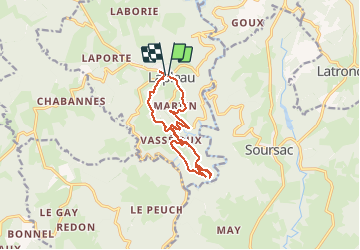
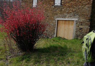
Randonnée Marche de 12,2 km à découvrir à Nouvelle-Aquitaine, Corrèze, Lapleau. Cette randonnée est proposée par honda400xr.
Description
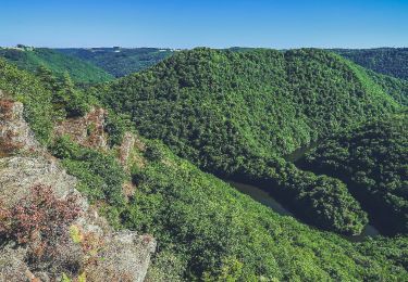
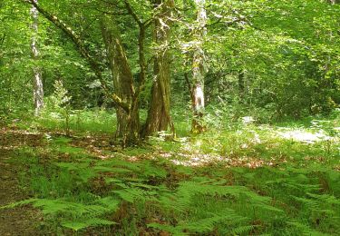
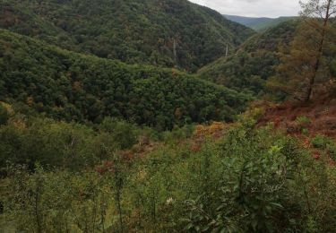
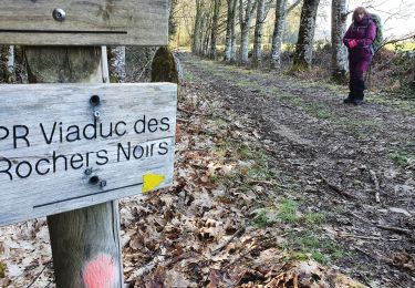
Belle randonnée qui empreinte en partie une ancienne voie ferré
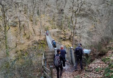
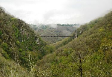
À voir le viaduc du rocher noir construit en 1913.
Visite de Lapleau.
Localisation
Pays :
France
Région :
Nouvelle-Aquitaine
Département/Province :
Corrèze
Commune :
Lapleau
Localité :
Unknown
Départ:(Dec)
Départ:(UTM)
434654 ; 5015896 (31T) N.
Commentaires
Randonnées à proximité
![Randonnée Marche Soursac - Soursac_Rochers_Noirs - Photo](https://media.geolcdn.com/t/375/260/b0d76ef7-ad31-49e1-a93d-fc830c4113fa.jpg&format=jpg&maxdim=2)
![Marche Marche](https://static1.geolcdn.com/sitytour/trail-icons/101.png)
Soursac_Rochers_Noirs
Marche
Moyen
Soursac,
Nouvelle-Aquitaine,
Corrèze,
France
![](/images/other/stat-length.png)
10,5 km | 14,4 km-effort
3h 0min
![](https://static1.geolcdn.com/siteimages/upload/files/16400158638029165_repeat_loop_refresh_sync_direction_icon.png)
Oui
![Randonnée Marche Saint-Pantaléon-de-Lapleau - St Pantaleon_Luzege - Photo](https://media.geolcdn.com/t/375/260/34576bdf-919b-48af-9826-42c86b9ec9ee.jpg&format=jpg&maxdim=2)
![Marche Marche](https://static1.geolcdn.com/sitytour/trail-icons/101.png)
St Pantaleon_Luzege
Marche
Moyen
(2)
Saint-Pantaléon-de-Lapleau,
Nouvelle-Aquitaine,
Corrèze,
France
![](/images/other/stat-length.png)
12,3 km | 18,2 km-effort
4h 0min
![](https://static1.geolcdn.com/siteimages/upload/files/16400158638029165_repeat_loop_refresh_sync_direction_icon.png)
Oui
![Randonnée Marche Soursac - Soursac_Spontour - Photo](https://media.geolcdn.com/t/375/260/2c029f0d-195a-4ddf-bf38-4d0cdf096c02.jpg&format=jpg&maxdim=2)
![Marche Marche](https://static1.geolcdn.com/sitytour/trail-icons/101.png)
Soursac_Spontour
Marche
Moyen
(2)
Soursac,
Nouvelle-Aquitaine,
Corrèze,
France
![](/images/other/stat-length.png)
15,2 km | 22 km-effort
5h 0min
![](https://static1.geolcdn.com/siteimages/upload/files/16400158638029165_repeat_loop_refresh_sync_direction_icon.png)
Oui
![Randonnée Marche Lapleau - Viaduc des pierres noires depuis Lapleau - Photo](https://media.geolcdn.com/t/375/260/ffa71253-2e5c-4876-9cd9-66930580b9eb.jpg&format=jpg&maxdim=2)
![Marche Marche](https://static1.geolcdn.com/sitytour/trail-icons/101.png)
Viaduc des pierres noires depuis Lapleau
Marche
Moyen
Lapleau,
Nouvelle-Aquitaine,
Corrèze,
France
![](/images/other/stat-length.png)
11,2 km | 16,2 km-effort
4h 2min
![](https://static1.geolcdn.com/siteimages/upload/files/16400158638029165_repeat_loop_refresh_sync_direction_icon.png)
Oui
![Randonnée Marche Lapleau - passerelle 1 - Photo](https://media.geolcdn.com/t/375/260/e9af52c5-4ad0-4617-8e86-33ea030733a1.jpg&format=jpg&maxdim=2)
![Marche Marche](https://static1.geolcdn.com/sitytour/trail-icons/101.png)
passerelle 1
Marche
Très difficile
Lapleau,
Nouvelle-Aquitaine,
Corrèze,
France
![](/images/other/stat-length.png)
16 km | 24 km-effort
5h 4min
![](https://static1.geolcdn.com/siteimages/upload/files/16400158638029165_repeat_loop_refresh_sync_direction_icon.png)
Oui
![Randonnée Marche Laval-sur-Luzège - Fred Laval sur luzege_1 - Photo](https://media.geolcdn.com/t/375/260/03c07a16-c5ff-42ee-ba0c-4d95d3c81736.jpg&format=jpg&maxdim=2)
![Marche Marche](https://static1.geolcdn.com/sitytour/trail-icons/101.png)
Fred Laval sur luzege_1
Marche
Très facile
Laval-sur-Luzège,
Nouvelle-Aquitaine,
Corrèze,
France
![](/images/other/stat-length.png)
10,7 km | 13,9 km-effort
3h 22min
![](https://static1.geolcdn.com/siteimages/upload/files/16400158638029165_repeat_loop_refresh_sync_direction_icon.png)
Oui
![Randonnée Marche Soursac - Fred les roches noires - Photo](https://media.geolcdn.com/t/375/260/ec608207-f431-49a6-82e4-f0bedcbf0990.jpg&format=jpg&maxdim=2)
![Marche Marche](https://static1.geolcdn.com/sitytour/trail-icons/101.png)
Fred les roches noires
Marche
Très facile
Soursac,
Nouvelle-Aquitaine,
Corrèze,
France
![](/images/other/stat-length.png)
11,7 km | 15,3 km-effort
3h 46min
![](https://static1.geolcdn.com/siteimages/upload/files/16400158638029165_repeat_loop_refresh_sync_direction_icon.png)
Oui
![Randonnée Marche Lapleau - viaduc rochers noirs - Photo](https://media.geolcdn.com/t/375/260/9761b47e-b9e1-4080-a5c7-3102395a98fa.jpg&format=jpg&maxdim=2)
![Marche Marche](https://static1.geolcdn.com/sitytour/trail-icons/101.png)
viaduc rochers noirs
Marche
Moyen
(1)
Lapleau,
Nouvelle-Aquitaine,
Corrèze,
France
![](/images/other/stat-length.png)
9,9 km | 13,9 km-effort
3h 47min
![](https://static1.geolcdn.com/siteimages/upload/files/16400158638029165_repeat_loop_refresh_sync_direction_icon.png)
Oui
![Randonnée Marche Soursac - Du plateau Soursacois aux gorges de la Luzège - Soursac - Pays de Haute Corrèze - Photo](https://media.geolcdn.com/t/375/260/ext.jpg?maxdim=2&url=https%3A%2F%2Fservices.sitytrail.com%2FGeolivesWS%2FDownloadMedia.ashx%3FTrailID%3D112407%26Media%3D10530_1.jpg)
![Marche Marche](https://static1.geolcdn.com/sitytour/trail-icons/101.png)
Du plateau Soursacois aux gorges de la Luzège - Soursac - Pays de Haute Corrèze
Marche
Moyen
(1)
Soursac,
Nouvelle-Aquitaine,
Corrèze,
France
![](/images/other/stat-length.png)
14,8 km | 20 km-effort
4h 0min
![](https://static1.geolcdn.com/siteimages/upload/files/16400158638029165_repeat_loop_refresh_sync_direction_icon.png)
Oui