![](/images/other/stat-length.png)
![Randonnée Marche Labastide-en-Val - Labastide-En-val - Photo](https://media.geolcdn.com/t/1900/400/ext.pjpeg?maxdim=2&url=https%3A%2F%2Fstatic1.geolcdn.com%2Fsiteimages%2Fupload%2Ffiles%2F1553511878bg_sport_marche.png)
Labastide-En-val
mikaou.t
Utilisateur
![Longueur](/images/other/stat-length.png)
Longueur
11 km
![Altitude max](https://static1.geolcdn.com/siteimages/upload/files/1508320355ic_sort_altitude_max_24dp.png)
Altitude max
647 m
![Dénivelé positif](https://static1.geolcdn.com/siteimages/upload/files/1508320355ic_sort_den_pos_24dp.png)
Dénivelé positif
406 m
![Km-Effort](/images/other/stat-length.png)
Km-Effort
16,4 km
![Altitude min](https://static1.geolcdn.com/siteimages/upload/files/1508320355ic_sort_altitude_min_24dp.png)
Altitude min
245 m
![Dénivelé négatif](https://static1.geolcdn.com/siteimages/upload/files/1508320355ic_sort_den_neg_24dp.png)
Dénivelé négatif
406 m
![Boucle](https://static1.geolcdn.com/siteimages/upload/files/16400158638029165_repeat_loop_refresh_sync_direction_icon.png)
Boucle
Oui
Date de création :
2020-07-20 08:10:41.813
Dernière modification :
2020-07-21 14:32:02.239
![Marche](https://static1.geolcdn.com/sitytour/trail-icons/101.png)
3h25
Difficulté : Moyen
![Scannez ce code QR pour ouvrir la randonnée dans l'application SityTrail](https://capi.geolives.com/qq0zvz2zws4bq2lad0pu/sitytour/trails/2484556/qr.png?size=200)
Application GPS de randonnée GRATUITE
À propos
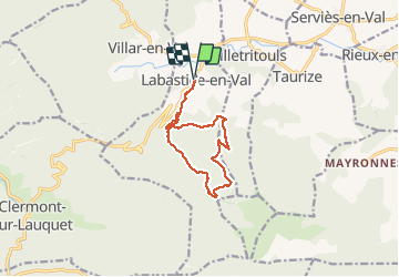
Randonnée Marche de 11 km à découvrir à Occitanie, Aude, Labastide-en-Val. Cette randonnée est proposée par mikaou.t.
Description
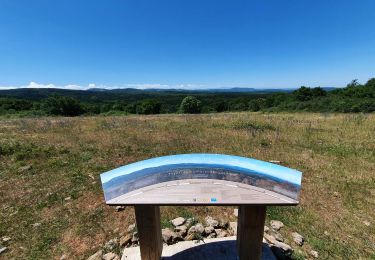
Départ du pont à côté de l'église.
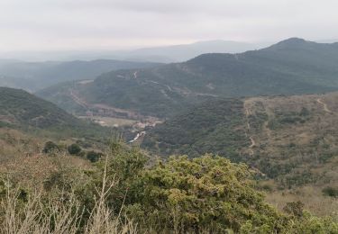
Circuit balisé en jaune. A la fin du circuit, le tracé poursuit sur la large piste forestière afin de passer à proximité du barrage sur la rivière et rejoint ensuite le chemin du départ afin d'éviter la route bitumée.
Localisation
Pays :
France
Région :
Occitanie
Département/Province :
Aude
Commune :
Labastide-en-Val
Localité :
Unknown
Départ:(Dec)
Départ:(UTM)
457094 ; 4769336 (31T) N.
Commentaires
Randonnées à proximité
![Randonnée Marche Labastide-en-Val - Labastide en val- Plateau Lacamp - Photo](https://media.geolcdn.com/t/375/260/f954c292-c7f5-4aab-a568-15dfd0efbbfe.jpg&format=jpg&maxdim=2)
![Marche Marche](https://static1.geolcdn.com/sitytour/trail-icons/101.png)
Labastide en val- Plateau Lacamp
Marche
Moyen
Labastide-en-Val,
Occitanie,
Aude,
France
![](/images/other/stat-length.png)
20 km | 28 km-effort
5h 4min
![](https://static1.geolcdn.com/siteimages/upload/files/16400158638029165_repeat_loop_refresh_sync_direction_icon.png)
Oui
![Marche Marche](https://static1.geolcdn.com/sitytour/trail-icons/101.png)
Le chemin des panoramas à Labastide-en-Val (variante)
Marche
Moyen
Labastide-en-Val,
Occitanie,
Aude,
France
![](/images/other/stat-length.png)
16,7 km | 24 km-effort
5h 0min
![](https://static1.geolcdn.com/siteimages/upload/files/16400158638029165_repeat_loop_refresh_sync_direction_icon.png)
Oui
![Randonnée Marche Taurize - Taurize - Photo](https://media.geolcdn.com/t/375/260/bad6b247-77be-4158-8da2-ffd1423076fe.jpg&format=jpg&maxdim=2)
![Marche Marche](https://static1.geolcdn.com/sitytour/trail-icons/101.png)
![Randonnée Marche nordique Labastide-en-Val - Chemin des panoramas - Photo](https://media.geolcdn.com/t/375/260/5249dee0-6ad6-4fca-8c06-4439e9a7bbf3.jpg&format=jpg&maxdim=2)
![Marche nordique Marche nordique](https://static1.geolcdn.com/sitytour/trail-icons/102.png)
Chemin des panoramas
Marche nordique
Difficile
Labastide-en-Val,
Occitanie,
Aude,
France
![](/images/other/stat-length.png)
18,7 km | 26 km-effort
Inconnu
![](https://static1.geolcdn.com/siteimages/upload/files/16400158638029165_repeat_loop_refresh_sync_direction_icon.png)
Oui
![Randonnée Marche Taurize - le roc du Causse - Photo](https://media.geolcdn.com/t/375/260/ext.jpg?maxdim=2&url=https%3A%2F%2Fstatic1.geolcdn.com%2Fsiteimages%2Fupload%2Ffiles%2F1553511878bg_sport_marche.png)
![Marche Marche](https://static1.geolcdn.com/sitytour/trail-icons/101.png)
le roc du Causse
Marche
Moyen
Taurize,
Occitanie,
Aude,
France
![](/images/other/stat-length.png)
11,5 km | 16,5 km-effort
3h 52min
![](https://static1.geolcdn.com/siteimages/upload/files/16400158638029165_repeat_loop_refresh_sync_direction_icon.png)
Oui
![Randonnée Marche Taurize - Taurize - Photo](https://media.geolcdn.com/t/375/260/ext.jpg?maxdim=2&url=https%3A%2F%2Fstatic1.geolcdn.com%2Fsiteimages%2Fupload%2Ffiles%2F1553511878bg_sport_marche.png)
![Marche Marche](https://static1.geolcdn.com/sitytour/trail-icons/101.png)
![Randonnée Marche Villar-en-Val - sentier en poésie - Photo](https://media.geolcdn.com/t/375/260/ext.jpg?maxdim=2&url=https%3A%2F%2Fstatic1.geolcdn.com%2Fsiteimages%2Fupload%2Ffiles%2F1553511878bg_sport_marche.png)
![Marche Marche](https://static1.geolcdn.com/sitytour/trail-icons/101.png)
sentier en poésie
Marche
Facile
Villar-en-Val,
Occitanie,
Aude,
France
![](/images/other/stat-length.png)
6,4 km | 8,6 km-effort
2h 23min
![](https://static1.geolcdn.com/siteimages/upload/files/16400158638029165_repeat_loop_refresh_sync_direction_icon.png)
Oui
![Randonnée Marche Taurize - Taurize et le Pech Taurillou - Photo](https://media.geolcdn.com/t/375/260/ext.jpg?maxdim=2&url=https%3A%2F%2Fstatic1.geolcdn.com%2Fsiteimages%2Fupload%2Ffiles%2F1553511878bg_sport_marche.png)
![Marche Marche](https://static1.geolcdn.com/sitytour/trail-icons/101.png)
Taurize et le Pech Taurillou
Marche
Moyen
Taurize,
Occitanie,
Aude,
France
![](/images/other/stat-length.png)
6,3 km | 9,4 km-effort
18h 50min
![](https://static1.geolcdn.com/siteimages/upload/files/16400158638029165_repeat_loop_refresh_sync_direction_icon.png)
Oui
![Randonnée Marche Taurize - taurize - Photo](https://media.geolcdn.com/t/375/260/ext.jpg?maxdim=2&url=https%3A%2F%2Fstatic1.geolcdn.com%2Fsiteimages%2Fupload%2Ffiles%2F1553511878bg_sport_marche.png)
![Marche Marche](https://static1.geolcdn.com/sitytour/trail-icons/101.png)