![](/images/other/stat-length.png)
![Randonnée Marche Carqueiranne - boucle depuis Carquierane - Photo](https://media.geolcdn.com/t/1900/400/4147b053-39df-4baa-ad61-fbb5a9cff415.jpg&format=pjpeg&maxdim=2)
boucle depuis Carquierane
cousam
Utilisateur
![Longueur](/images/other/stat-length.png)
Longueur
14,3 km
![Altitude max](https://static1.geolcdn.com/siteimages/upload/files/1508320355ic_sort_altitude_max_24dp.png)
Altitude max
283 m
![Dénivelé positif](https://static1.geolcdn.com/siteimages/upload/files/1508320355ic_sort_den_pos_24dp.png)
Dénivelé positif
451 m
![Km-Effort](/images/other/stat-length.png)
Km-Effort
20 km
![Altitude min](https://static1.geolcdn.com/siteimages/upload/files/1508320355ic_sort_altitude_min_24dp.png)
Altitude min
-1 m
![Dénivelé négatif](https://static1.geolcdn.com/siteimages/upload/files/1508320355ic_sort_den_neg_24dp.png)
Dénivelé négatif
454 m
![Boucle](https://static1.geolcdn.com/siteimages/upload/files/16400158638029165_repeat_loop_refresh_sync_direction_icon.png)
Boucle
Non
Date de création :
2020-07-18 07:48:09.577
Dernière modification :
2021-04-12 18:25:30.221
![Marche](https://static1.geolcdn.com/sitytour/trail-icons/101.png)
3h53
Difficulté : Très facile
![Scannez ce code QR pour ouvrir la randonnée dans l'application SityTrail](https://capi.geolives.com/qq0zvz2zws4bq2lad0pu/sitytour/trails/2480377/qr.png?size=200)
Application GPS de randonnée GRATUITE
À propos
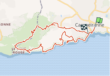
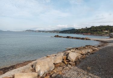
Randonnée Marche de 14,3 km à découvrir à Provence-Alpes-Côte d'Azur, Var, Carqueiranne. Cette randonnée est proposée par cousam.
Description
Le sentier litoral (marqué PR variante sur la carte et le guide sentier du littoral 2018) n'existe plus. Ce sont des propriétées privées.
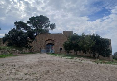
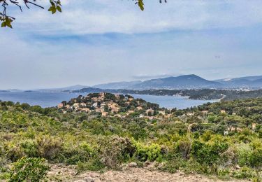
La partie après la mine est bien passé part les forts Gavaresse, Collé Noir, et de la Bayarde.
Localisation
Pays :
France
Région :
Provence-Alpes-Côte d'Azur
Département/Province :
Var
Commune :
Carqueiranne
Localité :
Unknown
Départ:(Dec)
Départ:(UTM)
262304 ; 4774945 (32T) N.
Commentaires
Randonnées à proximité
![Randonnée Marche La Crau - Le Paradis et le mont des oiseaux - Photo](https://media.geolcdn.com/t/375/260/3ea9709f-1bf2-4174-850e-73122825f7f5.jpg&format=jpg&maxdim=2)
![Marche Marche](https://static1.geolcdn.com/sitytour/trail-icons/101.png)
Le Paradis et le mont des oiseaux
Marche
Moyen
(1)
La Crau,
Provence-Alpes-Côte d'Azur,
Var,
France
![](/images/other/stat-length.png)
12,5 km | 19,9 km-effort
6h 30min
![](https://static1.geolcdn.com/siteimages/upload/files/16400158638029165_repeat_loop_refresh_sync_direction_icon.png)
Oui
![Randonnée Marche Le Pradet - le Pradet - les trois forts - Photo](https://media.geolcdn.com/t/375/260/f3d5c1c4-abd6-4c30-a189-71ee7c6f2626.jpg&format=jpg&maxdim=2)
![Marche Marche](https://static1.geolcdn.com/sitytour/trail-icons/101.png)
le Pradet - les trois forts
Marche
Très difficile
(2)
Le Pradet,
Provence-Alpes-Côte d'Azur,
Var,
France
![](/images/other/stat-length.png)
13,3 km | 19,6 km-effort
4h 27min
![](https://static1.geolcdn.com/siteimages/upload/files/16400158638029165_repeat_loop_refresh_sync_direction_icon.png)
Oui
![Randonnée A pied Le Pradet - le pradet plage de la garonne la mine - Photo](https://media.geolcdn.com/t/375/260/ext.jpg?maxdim=2&url=https%3A%2F%2Fstatic1.geolcdn.com%2Fsiteimages%2Fupload%2Ffiles%2F1545311037marcheuse_200dpi.jpg)
![A pied A pied](https://static1.geolcdn.com/sitytour/trail-icons/100.png)
le pradet plage de la garonne la mine
A pied
Facile
(1)
Le Pradet,
Provence-Alpes-Côte d'Azur,
Var,
France
![](/images/other/stat-length.png)
6,1 km | 8,2 km-effort
Inconnu
![](https://static1.geolcdn.com/siteimages/upload/files/16400158638029165_repeat_loop_refresh_sync_direction_icon.png)
Oui
![Randonnée Marche Le Pradet - les 3 forts depuis la plage de la Garonne - Photo](https://media.geolcdn.com/t/375/260/1cc1b5b0-8fc0-47a1-b418-a51de495ba7d.jpg&format=jpg&maxdim=2)
![Marche Marche](https://static1.geolcdn.com/sitytour/trail-icons/101.png)
les 3 forts depuis la plage de la Garonne
Marche
Très difficile
Le Pradet,
Provence-Alpes-Côte d'Azur,
Var,
France
![](/images/other/stat-length.png)
16,7 km | 24 km-effort
3h 59min
![](https://static1.geolcdn.com/siteimages/upload/files/16400158638029165_repeat_loop_refresh_sync_direction_icon.png)
Oui
![Randonnée Marche Le Pradet - Mine de la Garonne 2-18-10-2024 - Photo](https://media.geolcdn.com/t/375/260/eb51cf3e-5952-413e-b535-93de1e3f672e.jpg&format=jpg&maxdim=2)
![Marche Marche](https://static1.geolcdn.com/sitytour/trail-icons/101.png)
Mine de la Garonne 2-18-10-2024
Marche
Facile
Le Pradet,
Provence-Alpes-Côte d'Azur,
Var,
France
![](/images/other/stat-length.png)
7,2 km | 9,6 km-effort
1h 55min
![](https://static1.geolcdn.com/siteimages/upload/files/16400158638029165_repeat_loop_refresh_sync_direction_icon.png)
Oui
![Randonnée Marche Le Pradet - Les 3 forts-la Garonne-21-04-23 - Photo](https://media.geolcdn.com/t/375/260/cdf1f267-1743-49a7-b754-ec47dc9a915c.jpg&format=jpg&maxdim=2)
![Marche Marche](https://static1.geolcdn.com/sitytour/trail-icons/101.png)
Les 3 forts-la Garonne-21-04-23
Marche
Moyen
Le Pradet,
Provence-Alpes-Côte d'Azur,
Var,
France
![](/images/other/stat-length.png)
14,5 km | 21 km-effort
3h 56min
![](https://static1.geolcdn.com/siteimages/upload/files/16400158638029165_repeat_loop_refresh_sync_direction_icon.png)
Oui
![Randonnée Marche Le Pradet - pointe du baou rouge - Photo](https://media.geolcdn.com/t/375/260/638f4642-859f-44ca-89f6-effdb663d305.jpg&format=jpg&maxdim=2)
![Marche Marche](https://static1.geolcdn.com/sitytour/trail-icons/101.png)
pointe du baou rouge
Marche
Moyen
Le Pradet,
Provence-Alpes-Côte d'Azur,
Var,
France
![](/images/other/stat-length.png)
6,8 km | 8,9 km-effort
2h 20min
![](https://static1.geolcdn.com/siteimages/upload/files/16400158638029165_repeat_loop_refresh_sync_direction_icon.png)
Oui
![Randonnée Marche Hyères - Giens - Port Auguier - Chemin côtier - Photo](https://media.geolcdn.com/t/375/260/8600b71c-2160-4e50-bd7c-bba2a25051e4.jpg&format=jpg&maxdim=2)
![Marche Marche](https://static1.geolcdn.com/sitytour/trail-icons/101.png)
Giens - Port Auguier - Chemin côtier
Marche
Facile
Hyères,
Provence-Alpes-Côte d'Azur,
Var,
France
![](/images/other/stat-length.png)
8,6 km | 10,7 km-effort
6h 41min
![](https://static1.geolcdn.com/siteimages/upload/files/16400158638029165_repeat_loop_refresh_sync_direction_icon.png)
Oui
![Randonnée Marche Carqueiranne - la grotte du paradis - Photo](https://media.geolcdn.com/t/375/260/9486f261-69b8-4de0-9e87-579eb1d901e8.jpg&format=jpg&maxdim=2)
![Marche Marche](https://static1.geolcdn.com/sitytour/trail-icons/101.png)
la grotte du paradis
Marche
Facile
(1)
Carqueiranne,
Provence-Alpes-Côte d'Azur,
Var,
France
![](/images/other/stat-length.png)
3,9 km | 6,6 km-effort
1h 35min
![](https://static1.geolcdn.com/siteimages/upload/files/16400158638029165_repeat_loop_refresh_sync_direction_icon.png)
Oui