![](/images/other/stat-length.png)
![Randonnée Marche Vilcey-sur-Trey - Vilcey sur Trey - Photo](https://media.geolcdn.com/t/1900/400/60becd6f-0284-4664-bb7c-b37cff85d5cd.jpg&format=pjpeg&maxdim=2)
Vilcey sur Trey
Greg813
Utilisateur
![Longueur](/images/other/stat-length.png)
Longueur
17,2 km
![Altitude max](https://static1.geolcdn.com/siteimages/upload/files/1508320355ic_sort_altitude_max_24dp.png)
Altitude max
362 m
![Dénivelé positif](https://static1.geolcdn.com/siteimages/upload/files/1508320355ic_sort_den_pos_24dp.png)
Dénivelé positif
340 m
![Km-Effort](/images/other/stat-length.png)
Km-Effort
22 km
![Altitude min](https://static1.geolcdn.com/siteimages/upload/files/1508320355ic_sort_altitude_min_24dp.png)
Altitude min
226 m
![Dénivelé négatif](https://static1.geolcdn.com/siteimages/upload/files/1508320355ic_sort_den_neg_24dp.png)
Dénivelé négatif
347 m
![Boucle](https://static1.geolcdn.com/siteimages/upload/files/16400158638029165_repeat_loop_refresh_sync_direction_icon.png)
Boucle
Oui
Date de création :
2020-07-17 14:09:39.53
Dernière modification :
2020-07-21 16:27:29.146
![Marche](https://static1.geolcdn.com/sitytour/trail-icons/101.png)
4h50
Difficulté : Difficile
![Scannez ce code QR pour ouvrir la randonnée dans l'application SityTrail](https://capi.geolives.com/qq0zvz2zws4bq2lad0pu/sitytour/trails/2479276/qr.png?size=200)
Application GPS de randonnée GRATUITE
À propos
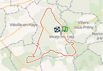
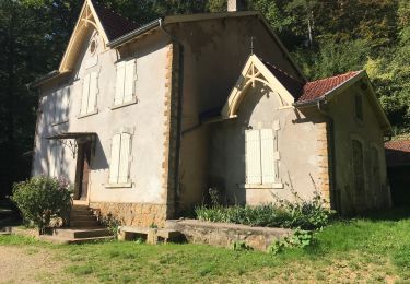
Randonnée Marche de 17,2 km à découvrir à Grand Est, Meurthe-et-Moselle, Vilcey-sur-Trey. Cette randonnée est proposée par Greg813.
Description
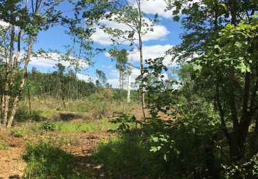
Randonnée dans les forêts jouxtant Vilcey sur Trey.
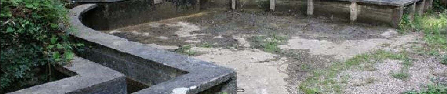
Passage par les vestiges des positions allemandes de la première guerre mondiale.
Les chemins sont assez dégagés et bien entretenus.
Localisation
Pays :
France
Région :
Grand Est
Département/Province :
Meurthe-et-Moselle
Commune :
Vilcey-sur-Trey
Localité :
Unknown
Départ:(Dec)
Départ:(UTM)
717681 ; 5424491 (31U) N.
Commentaires
Randonnées à proximité
![Randonnée V.T.T. Pont-à-Mousson - Pose balises V3 - Photo](https://media.geolcdn.com/t/375/260/ext.jpg?maxdim=2&url=https%3A%2F%2Fstatic1.geolcdn.com%2Fsiteimages%2Fupload%2Ffiles%2F1524743154velo.jpg)
![V.T.T. V.T.T.](https://static1.geolcdn.com/sitytour/trail-icons/202.png)
Pose balises V3
V.T.T.
Moyen
(1)
Pont-à-Mousson,
Grand Est,
Meurthe-et-Moselle,
France
![](/images/other/stat-length.png)
19,9 km | 26 km-effort
2h 1min
![](https://static1.geolcdn.com/siteimages/upload/files/16400158638029165_repeat_loop_refresh_sync_direction_icon.png)
Non
![Randonnée Marche Montauville - AUDAX PONT A MOUSSON SI SEC - Photo](https://media.geolcdn.com/t/375/260/ext.jpg?maxdim=2&url=https%3A%2F%2Fstatic1.geolcdn.com%2Fsiteimages%2Fupload%2Ffiles%2F1553511878bg_sport_marche.png)
![Marche Marche](https://static1.geolcdn.com/sitytour/trail-icons/101.png)
AUDAX PONT A MOUSSON SI SEC
Marche
Difficile
(1)
Montauville,
Grand Est,
Meurthe-et-Moselle,
France
![](/images/other/stat-length.png)
50 km | 60 km-effort
13h 35min
![](https://static1.geolcdn.com/siteimages/upload/files/16400158638029165_repeat_loop_refresh_sync_direction_icon.png)
Oui
![Randonnée Marche Prény - Forêt de Preny dévastée quelle dommage - Photo](https://media.geolcdn.com/t/375/260/1f50b1f7-4c8a-4c2b-b85a-6e1416c0eb49.jpg&format=jpg&maxdim=2)
![Marche Marche](https://static1.geolcdn.com/sitytour/trail-icons/101.png)
Forêt de Preny dévastée quelle dommage
Marche
Moyen
Prény,
Grand Est,
Meurthe-et-Moselle,
France
![](/images/other/stat-length.png)
7,4 km | 9,7 km-effort
1h 14min
![](https://static1.geolcdn.com/siteimages/upload/files/16400158638029165_repeat_loop_refresh_sync_direction_icon.png)
Non
![Randonnée V.T.T. Vilcey-sur-Trey - Les villages du Saillant de St-Mihiel, aux portes de Pontà-Mousson. - Circuit n° 12 - Photo](https://media.geolcdn.com/t/375/260/ext.jpg?maxdim=2&url=https%3A%2F%2Fservices.sitytrail.com%2FGeolivesWS%2FDownloadMedia.ashx%3FTrailID%3D111742%26Media%3D8148_6.jpg)
![V.T.T. V.T.T.](https://static1.geolcdn.com/sitytour/trail-icons/202.png)
Les villages du Saillant de St-Mihiel, aux portes de Pontà-Mousson. - Circuit...
V.T.T.
Difficile
Vilcey-sur-Trey,
Grand Est,
Meurthe-et-Moselle,
France
![](/images/other/stat-length.png)
47 km | 56 km-effort
2h 30min
![](https://static1.geolcdn.com/siteimages/upload/files/16400158638029165_repeat_loop_refresh_sync_direction_icon.png)
Oui
![Randonnée Marche Maidières - Maidieres - Boucle des vergers - variante - Photo](https://media.geolcdn.com/t/375/260/367e0312-9c24-4fe6-924b-4469c90b860d.jpg&format=jpg&maxdim=2)
![Marche Marche](https://static1.geolcdn.com/sitytour/trail-icons/101.png)
Maidieres - Boucle des vergers - variante
Marche
Moyen
Maidières,
Grand Est,
Meurthe-et-Moselle,
France
![](/images/other/stat-length.png)
6,4 km | 8,7 km-effort
2h 1min
![](https://static1.geolcdn.com/siteimages/upload/files/16400158638029165_repeat_loop_refresh_sync_direction_icon.png)
Oui
![Randonnée Marche Maidières - Maidières Poterosse chemin de la croix robert GR5 Prochebois - Photo](https://media.geolcdn.com/t/375/260/01bc62b5-49ba-4f4b-9dd0-d4ce4af660a6.jpg&format=jpg&maxdim=2)
![Marche Marche](https://static1.geolcdn.com/sitytour/trail-icons/101.png)
Maidières Poterosse chemin de la croix robert GR5 Prochebois
Marche
Moyen
Maidières,
Grand Est,
Meurthe-et-Moselle,
France
![](/images/other/stat-length.png)
4 km | 5,8 km-effort
1h 30min
![](https://static1.geolcdn.com/siteimages/upload/files/16400158638029165_repeat_loop_refresh_sync_direction_icon.png)
Oui
![Randonnée Marche Montauville - montauville - père hilarion - Photo](https://media.geolcdn.com/t/375/260/15ceac34-5410-4401-901f-eb77da2fe81a.jpg&format=jpg&maxdim=2)
![Marche Marche](https://static1.geolcdn.com/sitytour/trail-icons/101.png)
montauville - père hilarion
Marche
Facile
Montauville,
Grand Est,
Meurthe-et-Moselle,
France
![](/images/other/stat-length.png)
10,2 km | 12,8 km-effort
3h 56min
![](https://static1.geolcdn.com/siteimages/upload/files/16400158638029165_repeat_loop_refresh_sync_direction_icon.png)
Oui
![Randonnée Marche Montauville - Le père Hilarion Montauville - Photo](https://media.geolcdn.com/t/375/260/8bcf192c-1c36-487f-9601-fef1b0fbc29c.jpg&format=jpg&maxdim=2)
![Marche Marche](https://static1.geolcdn.com/sitytour/trail-icons/101.png)
Le père Hilarion Montauville
Marche
Facile
Montauville,
Grand Est,
Meurthe-et-Moselle,
France
![](/images/other/stat-length.png)
6,6 km | 8,6 km-effort
2h 44min
![](https://static1.geolcdn.com/siteimages/upload/files/16400158638029165_repeat_loop_refresh_sync_direction_icon.png)
Oui
![Randonnée Marche Montauville - Bois le Prêtre Le 09/09/2023 - Photo](https://media.geolcdn.com/t/375/260/0218d1ec-e3d5-42ff-bbd3-74f988efec70.jpg&format=jpg&maxdim=2)
![Marche Marche](https://static1.geolcdn.com/sitytour/trail-icons/101.png)
Bois le Prêtre Le 09/09/2023
Marche
Moyen
(1)
Montauville,
Grand Est,
Meurthe-et-Moselle,
France
![](/images/other/stat-length.png)
9,9 km | 12,3 km-effort
2h 30min
![](https://static1.geolcdn.com/siteimages/upload/files/16400158638029165_repeat_loop_refresh_sync_direction_icon.png)
Oui