![](/images/other/stat-length.png)
![Randonnée Marche Arâches-la-Frasse - Mont Jovy pierre à Laya - Photo](https://media.geolcdn.com/t/1900/400/f39bd061-a8cf-4891-84d8-c02820fed170.jpg&format=pjpeg&maxdim=2)
Mont Jovy pierre à Laya
reneperrin
Utilisateur
![Longueur](/images/other/stat-length.png)
![Altitude max](https://static1.geolcdn.com/siteimages/upload/files/1508320355ic_sort_altitude_max_24dp.png)
![Dénivelé positif](https://static1.geolcdn.com/siteimages/upload/files/1508320355ic_sort_den_pos_24dp.png)
![Km-Effort](/images/other/stat-length.png)
![Altitude min](https://static1.geolcdn.com/siteimages/upload/files/1508320355ic_sort_altitude_min_24dp.png)
![Dénivelé négatif](https://static1.geolcdn.com/siteimages/upload/files/1508320355ic_sort_den_neg_24dp.png)
![Boucle](https://static1.geolcdn.com/siteimages/upload/files/16400158638029165_repeat_loop_refresh_sync_direction_icon.png)
![Marche](https://static1.geolcdn.com/sitytour/trail-icons/101.png)
1h26
Difficulté : Très facile
![Scannez ce code QR pour ouvrir la randonnée dans l'application SityTrail](https://capi.geolives.com/qq0zvz2zws4bq2lad0pu/sitytour/trails/2477883/qr.png?size=200)
Application GPS de randonnée GRATUITE
À propos
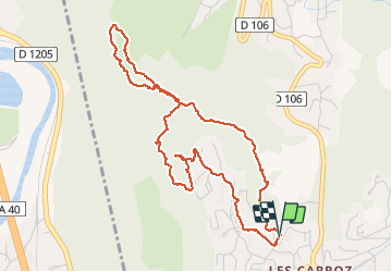
Randonnée Marche de 5,2 km à découvrir à Auvergne-Rhône-Alpes, Haute-Savoie, Arâches-la-Frasse. Cette randonnée est proposée par reneperrin.
Description
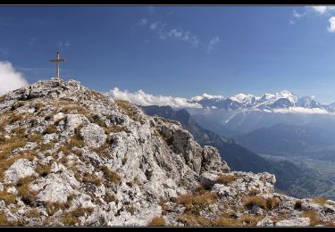
Petite randonnée très facile en forêt avec points de vue sur la vallée de l'Arve
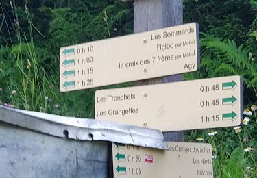
Le départ se fait au parking en bas de la route du val Renand, on se dirige vers Aquacime puis vers le Mont Jovy en traversant le pré du bois.
Ensuite on se dirige vers la pierre à Laya en passant par un autre point de vue sur la vallée. Le retour se fait en partie à travers l'alpage puis en forêt.
Localisation
Commentaires
Randonnées à proximité
![Randonnée Marche Magland - belvédère d Aulp - Photo](https://media.geolcdn.com/t/375/260/3d7c42d4-f0a9-4769-9285-e47bef46b3ca.jpg&format=jpg&maxdim=2)
![Marche Marche](https://static1.geolcdn.com/sitytour/trail-icons/101.png)
Marche
![](/images/other/stat-length.png)
![](https://static1.geolcdn.com/siteimages/upload/files/16400158638029165_repeat_loop_refresh_sync_direction_icon.png)
![Randonnée Marche Samoëns - plateau des saix . la corne . les biollaires . pointe de cupoire . plateau des saix - Photo](https://media.geolcdn.com/t/375/260/9a31bcfb-eada-4e13-9da7-575e6de96d67.jpg&format=jpg&maxdim=2)
![Marche Marche](https://static1.geolcdn.com/sitytour/trail-icons/101.png)
Marche
![](/images/other/stat-length.png)
![](https://static1.geolcdn.com/siteimages/upload/files/16400158638029165_repeat_loop_refresh_sync_direction_icon.png)
![Randonnée Marche Cluses - 08-03-2022 Pointe du Chevran - Photo](https://media.geolcdn.com/t/375/260/6d233612-2dc0-46da-be71-d5cc509b15b1.jpg&format=jpg&maxdim=2)
![Marche Marche](https://static1.geolcdn.com/sitytour/trail-icons/101.png)
Marche
![](/images/other/stat-length.png)
![](https://static1.geolcdn.com/siteimages/upload/files/16400158638029165_repeat_loop_refresh_sync_direction_icon.png)
![Randonnée Marche Nancy-sur-Cluses - Pointe d'Arbennes - Photo](https://media.geolcdn.com/t/375/260/fb8e1f23-28f7-4633-93ed-e0cc429ce276.jpg&format=jpg&maxdim=2)
![Marche Marche](https://static1.geolcdn.com/sitytour/trail-icons/101.png)
Marche
![](/images/other/stat-length.png)
![](https://static1.geolcdn.com/siteimages/upload/files/16400158638029165_repeat_loop_refresh_sync_direction_icon.png)
![Randonnée Marche Arâches-la-Frasse - Les Tronchets - Photo](https://media.geolcdn.com/t/375/260/1b22eca5-4d03-4493-9ac5-2c90d211f1bc.jpg&format=jpg&maxdim=2)
![Marche Marche](https://static1.geolcdn.com/sitytour/trail-icons/101.png)
Marche
![](/images/other/stat-length.png)
![](https://static1.geolcdn.com/siteimages/upload/files/16400158638029165_repeat_loop_refresh_sync_direction_icon.png)
![Randonnée Marche Arâches-la-Frasse - Vernant Grands Vans par le col de Véret - Photo](https://media.geolcdn.com/t/375/260/06ee9b71-5751-4664-80a4-c98989797b70.jpg&format=jpg&maxdim=2)
![Marche Marche](https://static1.geolcdn.com/sitytour/trail-icons/101.png)
Marche
![](/images/other/stat-length.png)
![](https://static1.geolcdn.com/siteimages/upload/files/16400158638029165_repeat_loop_refresh_sync_direction_icon.png)
![Randonnée Marche Arâches-la-Frasse - Les Carroz l'Arbaron en boucle - Photo](https://media.geolcdn.com/t/375/260/360e8a6b-b503-4616-ba4d-4d21ae7c55c0.jpg&format=jpg&maxdim=2)
![Marche Marche](https://static1.geolcdn.com/sitytour/trail-icons/101.png)
Marche
![](/images/other/stat-length.png)
![](https://static1.geolcdn.com/siteimages/upload/files/16400158638029165_repeat_loop_refresh_sync_direction_icon.png)
![Randonnée Marche Arâches-la-Frasse - les Carroz, tête de Saix boucle - Photo](https://media.geolcdn.com/t/375/260/fc10eab2-e7d0-43c5-ba5e-76349cca3bdc.jpg&format=jpg&maxdim=2)
![Marche Marche](https://static1.geolcdn.com/sitytour/trail-icons/101.png)
Marche
![](/images/other/stat-length.png)
![](https://static1.geolcdn.com/siteimages/upload/files/16400158638029165_repeat_loop_refresh_sync_direction_icon.png)
![Randonnée Marche Arâches-la-Frasse - randonnée en forêt, les Carroz, Araches, la Frasse - Photo](https://media.geolcdn.com/t/375/260/266ab88b-3ecc-4762-b4ff-c648b0c4392c.jpg&format=jpg&maxdim=2)
![Marche Marche](https://static1.geolcdn.com/sitytour/trail-icons/101.png)
Marche
![](/images/other/stat-length.png)
![](https://static1.geolcdn.com/siteimages/upload/files/16400158638029165_repeat_loop_refresh_sync_direction_icon.png)